Rotating-sector-laser-based position and pose measurement method of cantilever excavator

A cantilever roadheader and fan laser technology, which is applied in the directions of measuring devices, measuring instruments, surveying and navigation, etc., can solve problems such as poor visibility, calibration of inertial navigation systems, and miscellaneous equipment, and achieves low cost and high automation. Measure and improve the effect of molding quality

Inactive Publication Date: 2015-06-24
CHINA UNIV OF MINING & TECH (BEIJING)
View PDF0 Cites 21 Cited by
  • Summary
  • Abstract
  • Description
  • Claims
  • Application Information

AI Technical Summary

Problems solved by technology

However, the total station uses the laser beam as the measurement medium to locate a certain point in space, which can only realize point-to-point measurement, and has poor anti-blocking ability. There are many equipments in the coal mine excavation face, and the coal roadway is uneven, and the visibility is poor. , so the laser beam is easily blocked if the total station is used
For the inertial navigation system, the positioning error will increase with time, it is not suitable for long-distance and long-term measurement, and regular correction is required
However, the coal mine excavation face is generally located tens to hundreds of meters underground, and GPS and other positioning technologies cannot be used to correct the inertial navigation system
Therefore, most of the modern pose measurement methods are not suitable for the pose measurement of the cantilever roadheader

Method used


Image

  • Rotating-sector-laser-based position and pose measurement method of cantilever excavator
  • Rotating-sector-laser-based position and pose measurement method of cantilever excavator
  • Rotating-sector-laser-based position and pose measurement method of cantilever excavator

Examples


Embodiment Construction

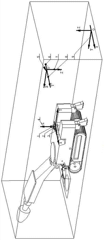
[0025] Such as figure 1 As shown, the method of measuring the pose of a cantilever roadheader using a space point three-dimensional coordinate measurement system based on sector laser angle measurement, the pose measurement process includes the following steps:

[0026] (1) Install the sector laser transmitter on the cantilever roadheader so that it is fixedly connected with the cantilever roadheader. The fan laser receiving end is installed in the formed roadway, that is, 3 non-collinear fan laser receivers.

[0027] (2) A coordinate system is constructed by the sector laser transmitter, which is called the fuselage coordinate system (O-XYZ). The fan laser transmitter is composed of a high-precision slide table, a high-precision turntable, a fan laser transmitter, and an initial reference. The initial position rotation axis of the fan laser transmitter is the Z axis, and the moving direction of the high-precision slide table is the X axis.

[0028] (3) A coordinate system i...


PUM


Abstract

The invention relates to a position and post measurement method of a cantilever excavator at an excavating workface of a coal mine. The method comprises the following steps that a space point three-dimensional coordinate measuring system for measuring angles based on rotating sector laser is fully utilized, namely, the sector laser transmission end of the system is mounted on a cantilever excavator body, while the sector laser receiving end (including three non-collinear sector laser receivers) is fixedly mounted at the back of a coal road excavated by the cantilever excavator; the coordinate values of a sector laser receiver relative to a space geodetic coordinate system can be measured by other measurement modes; the coordinate values of the sector laser receiver relative to the transmission end are measured through the sector emission transmission end and then are converted for calculating to obtain the three-dimensional coordinate values of three fixed points (non-collinear) on the cantilever excavator, relative to the space geodetic coordinate system; if the three-dimensional coordinate values of three fixed points (non-collinear) on a space rigid body, relative to the space geodetic coordinate system are known, the position and pose data of the space rigid body can be calculated.

Description

technical field [0001] The invention belongs to the technical field of position and posture measurement of construction machinery equipment, in particular to a method for measuring the position and attitude of a cantilever roadheader used in coal mines, and then precisely pointing the direction of the cantilever roadheader. Background technique [0002] The traditional position and orientation measurement method of the cantilever roadheader is the manual visual method, and the only reference of the cantilever roadheader in the coal roadway comes from the point laser pointer. A point laser pointing device (indicating the roadway design direction) is placed behind the cantilever roadheader, which forms a light spot on the excavation section at the front of the coal roadway. The driver of the cantilever roadheader must observe the position of the light spot on the excavation section with the naked eye during operation , Always pay attention to whether the direction of the roadw...

Claims


Application Information

Patent Timeline
Patent Type & Authority Applications(China)
IPC IPC(8): G01C21/00G01C15/00
CPCG01C21/00
Inventor 吴淼贾文浩符世琛陶云飞张敏骏宗凯薛光辉杨健健
Owner CHINA UNIV OF MINING & TECH (BEIJING)
Why Eureka
Try Eureka