Unmanned aerial vehicle autonomous navigation positioning method with assistance of visual information

A positioning method and autonomous navigation technology, applied in satellite radio beacon positioning systems, navigation, surveying and navigation, etc., can solve problems such as inability to provide navigation information, inability to differentiate navigation strategies, damage to UAVs and airborne equipment, etc.

Active Publication Date: 2015-06-24
BEIHANG UNIV
View PDF6 Cites 45 Cited by
  • Summary
  • Abstract
  • Description
  • Claims
  • Application Information

AI Technical Summary

Problems solved by technology

[0005] The present invention differs from other UAV autonomous navigation and positioning methods in that: in the currently published literature, the visual navigation results are used to assist the inertial navigation system to provide the navigation and positioning information of the UAV, but these navigation methods cannot be used in practical applications. According to the external environment and navigation results, different navigation strategies are adopted in a targeted manner, and the effectiveness of visual navigation information cannot be evaluated, which makes visual navigation information susceptible to errors, and cannot provide long-term stable navigation information, resulting in failure to complete scheduled tasks. Even lead to the risk of damage to drones and airborne equipment

Method used


Image

  • Unmanned aerial vehicle autonomous navigation positioning method with assistance of visual information
  • Unmanned aerial vehicle autonomous navigation positioning method with assistance of visual information
  • Unmanned aerial vehicle autonomous navigation positioning method with assistance of visual information

Examples


Embodiment Construction

[0049] The present invention will be further described below in conjunction with the accompanying drawings and specific embodiments.

[0050] The concrete implementation steps of a kind of visual information assisted UAV autonomous navigation positioning method of the present invention are as follows:

[0051] (1) Calibrate and compensate for accelerometers, gyroscopes, magnetic sensors, barometric altimeters and visual sensors;

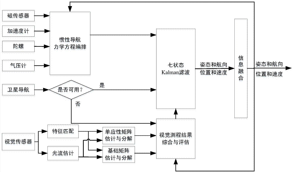
[0052] (2) if figure 1 As shown, according to the layout of the inertial navigation system mechanics equation, the output value of the accelerometer and gyroscope is used to calculate the motion information of the UAV in real time, including position, velocity and attitude;

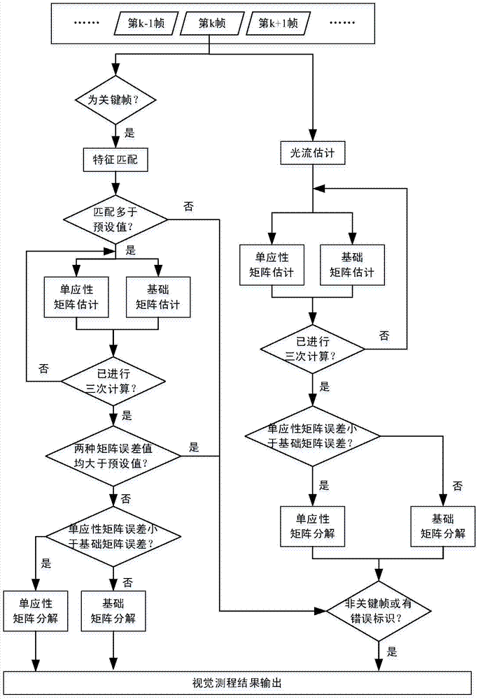
[0053] (3) if figure 2 As shown, the collected images are divided into ordinary frames and key frames, the inter-frame matching of ordinary frames is obtained by optical flow estimation method, and the inter-frame matching of key frames is obtained by feature matching method,...


PUM


Abstract

The invention discloses an unmanned aerial vehicle autonomous navigation positioning method with assistance of visual information. The positioning method aims at providing accurate unmanned aerial vehicle navigation positioning information by making use of a visual sensor and corresponding visual ranging algorithm. In the method, speed and position information of the unmanned aerial vehicle are calculated through a combined visual ranging algorithm, and are used for assisting inertial navigation positioning. When a GNSS (Global Navigation Satellite System) signal is available, inertial navigation system error is corrected through inertial navigation / GNSS combined navigation, and a visual ranging evaluation criterion is established; when the GNSS signal is unavailable, the visual ranging evaluation criterion is used for evaluating the visual ranging result obtained by the combined visual ranging algorithm, error of a inertial navigation system is estimated and compensated with the visual ranging result and the visual ranging evaluation result, and thus, continuous and reliable navigation positioning information is provided for the unmanned aerial vehicle. The method provided by the invention can continuously and steadily provide accurate navigation positioning information for an unmanned aerial vehicle control system for long time.

Description

technical field [0001] The invention relates to a visual information-assisted autonomous navigation and positioning method for unmanned aerial vehicles, in particular to an autonomous navigation and positioning method for unmanned aerial vehicles based on visual range measurement results to assist an inertial navigation system, which is suitable for autonomous navigation and positioning systems for unmanned aerial vehicles. Background technique [0002] Unmanned aerial vehicles (UAVs) are low-risk and low-cost automated flying vehicles that can operate autonomously to complete various tasks. They are widely used in military and civilian fields such as automatic transportation, regional surveillance, post-disaster reconstruction, complex environment detection, and ground target tracking. In order to complete tasks autonomously without unmanned monitoring, a stable, fast and accurate navigation system is crucial for UAVs. Due to the rapid error divergence of low-cost inertial ...

Claims


Application Information

Patent Timeline
Patent Type & Authority Applications(China)
IPC IPC(8): G01C21/16G01S19/49
CPCG01C21/165G01S19/49
Inventor 赵龙王丁周明月
Owner BEIHANG UNIV
Why Eureka
Try Eureka