True amplitude migration imaging method

A technology of migration imaging and true amplitude, applied in seismic signal recording, seismic signal processing, etc., can solve problems such as accurately solving acoustic wave equations, increasing the reliability of geological interpretation and seismic inversion analysis, etc.

Active Publication Date: 2015-10-21
CHINA UNIV OF GEOSCIENCES (BEIJING) +1
View PDF6 Cites 12 Cited by
  • Summary
  • Abstract
  • Description
  • Claims
  • Application Information

AI Technical Summary

Problems solved by technology

[0006] In view of the above problems, the present invention discloses a true amplitude migration imaging method, and proposes a land-based dual detector observation system, aiming to form a matching full-acoustic equation true amplitude prestack depth migration method based on the observation system, to overcome At present, the seismic data acquisition system only records

Method used


Image

  • True amplitude migration imaging method
  • True amplitude migration imaging method
  • True amplitude migration imaging method

Examples


Embodiment 1

[0081] Example 1 Steep Angle Inclined Interface Model

[0082] As shown in Fig. 4, in order to study and compare three migration algorithms: Kirchhoff prestack depth migration method, dual detector prestack depth migration method and prestack depth reverse time migration method, the lithology Ability to recognize changes. Among them, the velocity model is shown in Figure 4(a).

[0083] The specific operation is as follows:

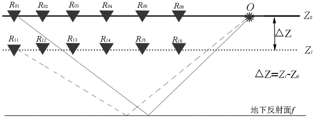
[0084] (1) A detector layer is arranged at a certain depth on the surface and underground, and multiple detector points are arranged on each layer. The detectors on the upper and lower layers are vertically corresponding, and the depth of the underground detector layer is a continuation step;

[0085] (2) The geophones of the same geophone layer are horizontally connected and a large line is responsible for transmitting the collected seismic signal data; the seismic signal data of each geophone point is collected;

[0086] (3) The geophones on the upper...

Embodiment 2

[0092] Example 2: Double layer interface model

[0093] As shown in Fig. 5, three migration algorithms are studied: Kirchhoff pre-stack depth migration method, dual detector pre-stack depth migration method and pre-stack depth reverse time migration method, under the influence of floating strata The ability to identify lithology of the underlying strata. The velocity model is shown in Fig. 5(a).

[0094] The specific operation is as follows:

[0095] (1) A detector layer is arranged at a certain depth on the surface and underground, and multiple detector points are arranged on each layer, and the detectors on the upper and lower layers correspond vertically; the depth of the detector layer underground is a continuation step;

[0096] (2) The geophones of the same geophone layer are horizontally connected and a large line is responsible for transmitting the collected seismic signal data; the seismic signal data of each geophone point is collected;

[0097] (3) The geophones on...

Embodiment 3

[0103] Example 3: Multiple Interface Models

[0104] like Image 6 , is to study three migration algorithms: Kirchhoff pre-stack depth migration method, dual-detector pre-stack depth migration method and pre-stack depth reverse-time migration method, the imaging ability and lithology identification ability of complex models .

[0105] The specific operation is as follows:

[0106] (1) A detector layer is arranged at a certain depth on the surface and underground, and multiple detector points are arranged on each layer, and the detectors on the upper and lower layers correspond vertically; the depth of the detector layer underground is a continuation step;

[0107] (2) The geophones of the same geophone layer are horizontally connected and a large line is responsible for transmitting the collected seismic signal data; the seismic signal data of each geophone point is collected;

[0108] (3) The geophones on the upper and lower floors are vertically aligned, and the necessary...


PUM


Abstract

The invention discloses a true amplitude migration imaging method, in particular, an onshore double/multi-detector total sound wave equation true amplitude pre-stack depth migration method. The method includes the following steps that: a plurality of detection layers are arranged on a ground surface or below the ground surface; seismic signal data are acquired; the partial derivatives of wave fields at the ground surface relative to depth are calculated; wave field continuation is performed a detection point wave field and a shot point wave field; and cross-correlation correlation imaging principles or reflection coefficient imaging principles are utilized to image the continued detection point wave field and shot point wave field. With the method of the invention adopted, a defect that an existing seismic data acquisition system can only record the values of wave fields at the ground surface and cannot accurately solve an acoustic wave equation at the depth domain can be eliminated; an acoustic wave equation can be utilized to accurately solve seismic wave field information; reliable subsurface structure and lithological information can be provided for subsequent geological interpretation personnel; the confidence level of geological interpretation and seismic inversion analysis can be improved; migration imaging can be performed on various kinds of wave fields; and the true amplitude migration of the lithological changes of subsurface structures can be reflected.

Description

technical field [0001] The invention relates to an underground structure imaging method, in particular to a migration imaging method in seismic exploration, which is mainly used in the migration imaging method in oil and gas resource exploration. Background technique [0002] Seismic exploration methods are currently an important method for oil, natural gas and other energy exploration, and seismic migration, as a key link in modern seismic exploration data processing, provides necessary technical support for seismic interpretation and lithology inversion. Therefore, the development of a true-amplitude seismic migration technique that can not only accurately reflect the underground structure but also reflect the formation lithology changes has always been a matter of concern. [0003] At present, conventional seismic migration processing technology, that is, modern conventional seismic data acquisition technology, only receives surface or sea surface wave field values ​​in s...

Claims


Application Information

Patent Timeline
IPC IPC(8): G01V1/24G01V1/28
Inventor 刘学伟尤加春
Owner CHINA UNIV OF GEOSCIENCES (BEIJING)
Why Eureka
Try Eureka