Automatic ortho-rectification method based on remote-sensing image of environmental No.1 satellite

A satellite remote sensing image and orthorectification technology, applied to instruments, character and pattern recognition, computer components, etc., can solve the problems of cumbersome process, high cost, uncontrollable image correction accuracy, etc., achieve high computing efficiency and ensure accurate degree of effect

Active Publication Date: 2015-11-11
CHINA CENT FOR RESOURCES SATELLITE DATA & APPL
View PDF5 Cites 18 Cited by
  • Summary
  • Abstract
  • Description
  • Claims
  • Application Information

AI Technical Summary

Problems solved by technology

However, stereo images are not easy to obtain for remote sensing images, the cost is high, and a certain number of control points need to be manually selected.
For the few existing remote sensing image automatic correction methods that use image matching and general empirical models, they only use corner point matching and quadratic polynomial models to apply them simply, and a fixed threshold needs to be set in each step. flexible, poor applicability
[0004] The shortcomings of the above methods are mainly reflected in: (1) manual selection of control poin

Method used


Image

  • Automatic ortho-rectification method based on remote-sensing image of environmental No.1 satellite
  • Automatic ortho-rectification method based on remote-sensing image of environmental No.1 satellite
  • Automatic ortho-rectification method based on remote-sensing image of environmental No.1 satellite

Examples


Embodiment Construction

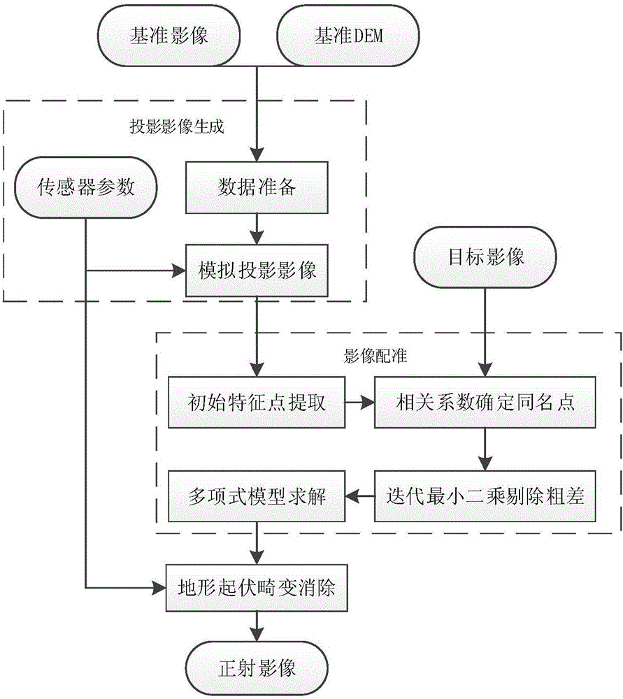
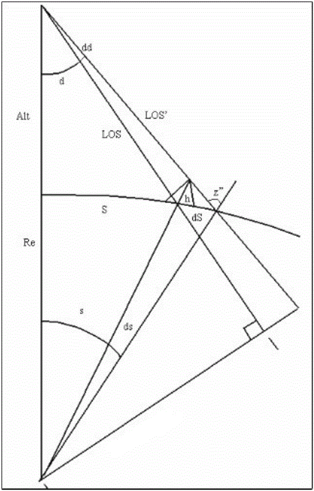
[0040] Below in conjunction with accompanying drawing and specific embodiment the present invention is described in further detail, as figure 1 Shown is the flow chart of the orthorectification of the present invention. Select an environmental satellite level 2 CCD image as the target data, set the Landsat satellite reference image containing the target data, and the coordinates of each pixel in the Landsat satellite reference image are the geographical coordinates of the real measurement; set the digital elevation data As reference data, the digital elevation data is to measure the altitude h of the real ground, and is used to restore the reference image attitude. Its recovery process is as follows figure 2 As shown in , the Landsat satellite orthoreference image is simulated as the projection image during imaging to solve the deviation parameters (that is, the simulation method), and the projection offset of point S on the Landsat satellite orthoreference image is added to...


PUM


Abstract

An automatic ortho-rectification method based on a remote-sensing image of an environmental No.1 satellite comprises the following steps of: (1) eliminating projection distortion caused by ground fluctuation in a reference image according to a geometric projection transformation principle to generate a simulated projection image; (2) finding possible feature points in the reference image and an original image by utilizing a Harris corner extraction algorithm; (3) finding possible homonymy points on the basis of the step (2) with a correlation coefficient method; (4) solving a relation coefficient between the reference image and the original image by using a polynomial model based on least squares; and (5) correcting the original image by utilizing the relation coefficient between the reference image and the original image, and eliminating the distortion caused by the ground fluctuation according to the geometric projection transformation principle again, so as to finally finish ortho-rectification. The method has the characteristics of high automation degree, no need of manually selecting control points, high correction precision and high production efficiency.

Description

technical field [0001] The invention relates to an automatic orthorectification method based on the remote sensing image of the Environment-1 satellite, which belongs to the technical field of remote-sensing image processing, and is suitable for the precise positioning of the remote-sensing image of the Environment-1 satellite, the extraction of image information and the preprocessing work of the production of special products, etc. . Background technique [0002] During the imaging process of satellite imagery, it is affected by many factors such as projection, camera axis tilt, earth curvature, and terrain fluctuations, resulting in different degrees of geometric deformation and distortion of each image point in the image. The orthorectification image can eliminate the image distortion caused by various factors in the imaging process, and restore a remote sensing image with accurate geographical location. Therefore, orthorectification of remote sensing images has become a...

Claims


Application Information

Patent Timeline
IPC IPC(8): G06K9/03
CPCG06V10/98
Inventor 吕争傅俏燕王小燕乔志远崔林
Owner CHINA CENT FOR RESOURCES SATELLITE DATA & APPL
Why Eureka
Try Eureka