Measured-landform-feature-based real-time adaptive adjusting method and apparatus for airborne laser radar parameters

An airborne laser radar and self-adaptive adjustment technology, applied in the direction of self-adaptive control, control/adjustment system, instrument, etc.

Active Publication Date: 2015-11-25
SHANDONG UNIV OF TECH
View PDF5 Cites 23 Cited by
  • Summary
  • Abstract
  • Description
  • Claims
  • Application Information

AI Technical Summary

Problems solved by technology

[0013] Aiming at the lack of methods and devices for real-time adaptive adjustment of airborne laser radar parameters according to the characteristics of terrain changes in the existing airborne laser radar measurement technology, the present invention provides an airborne laser scanning parameter based on the measured terrain characteristics The method and device ...

Method used


Image

  • Measured-landform-feature-based real-time adaptive adjusting method and apparatus for airborne laser radar parameters
  • Measured-landform-feature-based real-time adaptive adjusting method and apparatus for airborne laser radar parameters
  • Measured-landform-feature-based real-time adaptive adjusting method and apparatus for airborne laser radar parameters

Examples


Embodiment Construction

[0051] The patent embodiments of the present invention will be further described in detail below in conjunction with the accompanying drawings.

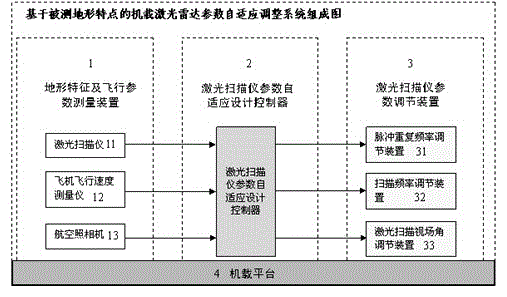
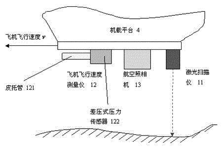
[0052] figure 1It is a composition diagram of the airborne lidar parameter adaptive adjustment system based on the characteristics of the measured terrain. The present invention provides a real-time adaptive adjustment method and device for airborne laser radar parameters based on the characteristics of the measured terrain, which is characterized in that it includes terrain characteristics and flight parameter measurement devices (1), laser scanner parameter adaptive design controller ( 2), a scanner parameter adjustment device (3), an airborne platform (4); the terrain feature and flight parameter measurement device (1) includes a laser scanner (11), an aircraft flight speed measuring instrument (12), and an aerial camera (13); the scanner parameter adjustment device (3) includes a pulse repetition frequency adjustment device (31)...


PUM


Abstract

The invention relates to a measured-landform-feature-based real-time adaptive adjusting method and apparatus for airborne laser radar parameters. A plane flies straightly at a constant speed with the altitude unchanged. When an elevation and a two-dimensional space frequency of a measured landform change, optimal computation is carried out to adjust setting values of a scanning field angle, a pulse repetition frequency, and a scanning frequency in real time, so that the laser scanning point cloud bandwidth is unchanged; meanwhile, the point cloud density meets the sampling theorem requirement all the time, thereby eliminating difficulty of distortion and data storage and processing for three-dimensional landform model reconstruction. Flight parameters and measured landform features are measured in real time by a laser scanner, a plane flight speed measurement instrument, and an aerial camera; with integrated computation, an elevation change and a two-dimensional space frequency of the landform are obtained; and then optimal computation is carried out to obtain optimal adjustment values of the three parameters including the pulse repetition frequency, the scanning frequency, and the scanning field angle of the laser scanner and real-time adjustment is carried out, thereby realizing real-time adaptive optimal measurement based on the measured-landform change.

Description

technical field [0001] The invention relates to the optimization design and real-time self-adaptive adjustment method of the working parameters of the airborne laser radar according to the characteristics of the terrain to be measured. Background technique [0002] Airborne lidar 3D imaging technology is a new technology in the field of terrain surveying and mapping. It can generate a digital surface model of the measured terrain, with the purpose of reproducing the real measured terrain without distortion. [0003] The measured terrain can be regarded as an elevation function on a two-dimensional plane, so the scanning measurement process of the airborne lidar on the measured ground is equivalent to a two-dimensional discrete sampling process. [0004] According to the two-dimensional sampling theorem in the reference (DigitalSignalandImageProcessing. Translation Edition / (US) Tamalbose. Wu Zhenyang, Zhou Lin et al. Translated. Digital Signal and Image Processing. Higher Edu...

Claims


Application Information

Patent Timeline
IPC IPC(8): G05B13/02
Inventor 王建军霍文骁李云龙
Owner SHANDONG UNIV OF TECH
Why Eureka
Try Eureka