Assessment method of agile imaging simulation and positioning accuracy of satellite

A satellite and imaging technology, applied in the field of remote sensing satellite image processing, can solve problems such as the decline of geometric positioning accuracy

Active Publication Date: 2015-12-09
SPACE STAR TECH CO LTD
View PDF4 Cites 10 Cited by
  • Summary
  • Abstract
  • Description
  • Claims
  • Application Information

AI Technical Summary

Problems solved by technology

[0005] The technical problem to be solved by the present invention is how to design a set of simulation system for automatically calculating attitude maneuvers and simulating sequence image generation under the conditions of comprehensive movement of agile satellites according to the satellite platform design parameters and application requirements

Method used


Image

  • Assessment method of agile imaging simulation and positioning accuracy of satellite
  • Assessment method of agile imaging simulation and positioning accuracy of satellite
  • Assessment method of agile imaging simulation and positioning accuracy of satellite

Examples


Embodiment Construction

[0033] The present invention will be described more fully hereinafter with reference to the accompanying drawings, in which exemplary embodiments of the invention are illustrated.

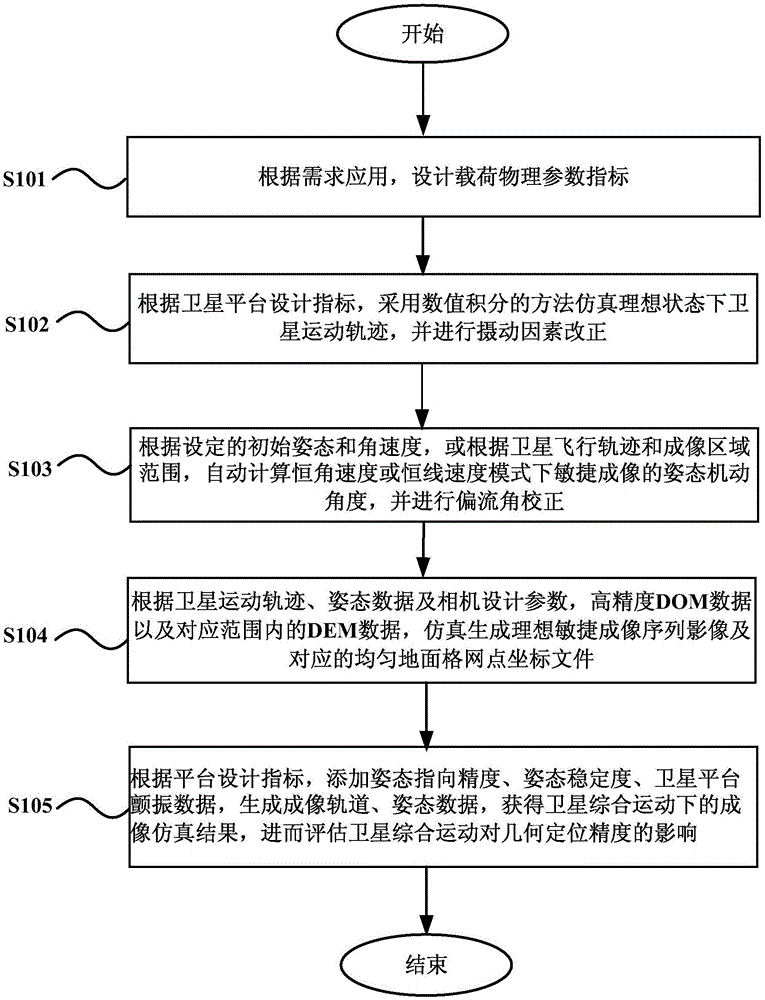
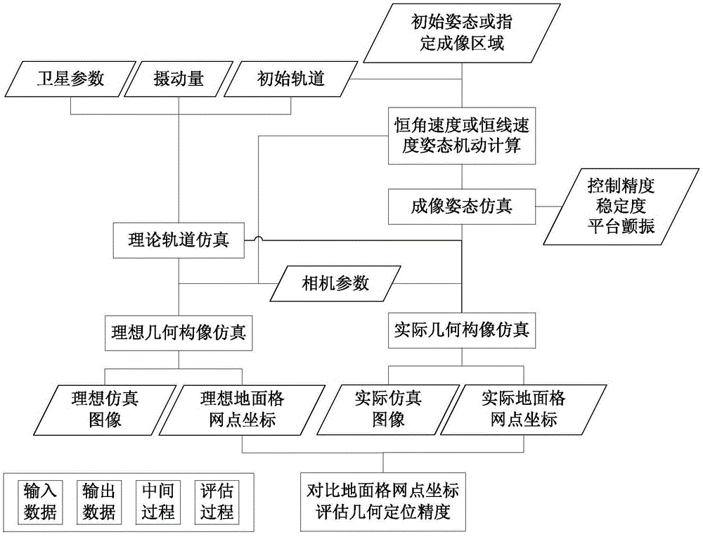
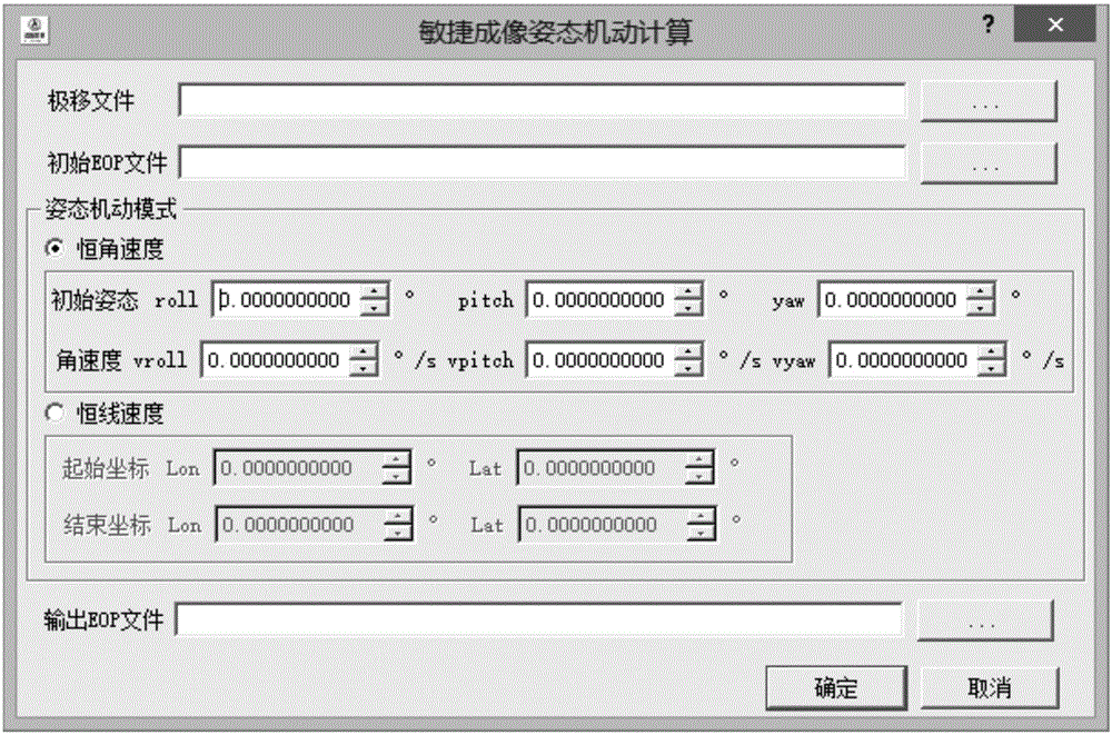
[0034] Relying on the "Optical Remote Sensing Satellite Imaging Simulation Design Platform" project, combined with the technical characteristics and project requirements, the present invention researches and designs the key technology and implementation process of optical remote sensing satellite imaging link simulation; completes the satellite platform parameter simulation, face-to-face Array camera physical parameter simulation, orbit and attitude data simulation modeling and realization; completed agile imaging mode attitude maneuver calculation and area array camera geometric configuration simulation modeling and realization; A large number of simulation experiments have been carried out to quantitatively evaluate the imaging geometric positioning accuracy under different design indicators.

[...


PUM


Abstract

The invention provides an assessment method of agile imaging simulation and positioning accuracy of a satellite. The assessment method comprises following steps: designing a load physical parameter index according to an application demand; adopting a numerical integration method to simulate the movement trajectory of the satellite in the ideal state and correcting perturbing factors according to a platform design index; calculating an attitude maneuver angle for agile imaging in the mode of constant angular velocity or constant linear velocity and performing correction of a drift angle; generating the ideal agile imaging sequence of images by simulation and corresponding coordinate files for uniform ground grid points based on the movement trajectory of the satellite, attitude data of exposure time, design parameters of a camera, DOM data and DEM data in a corresponding data range; and obtaining an imaging simulation result of synthetic movement of the satellite according to the platform design index and movement error terms so that influence of synthetic movement of the satellite upon geometric positioning accuracy is further assessed. The assessment method of agile imaging simulation and positioning accuracy of the satellite has following beneficial effects: by adoption of the method, a real motion state and an imaging process of the satellite on orbit can be simulated; and geometric positioning accuracy for agile imaging of synthetic movement of the satellite is assessed.

Description

technical field [0001] The invention relates to the technical field of image processing of remote sensing satellites, in particular to a satellite agile imaging simulation and positioning accuracy evaluation method, in particular to an agile imaging simulation and positioning accuracy evaluation method considering satellite comprehensive motion. Background technique [0002] In recent years, relevant research institutions at home and abroad have successively carried out a large number of research and development work on agile imaging remote sensing satellites, especially low-orbit video small satellites, which have become the most potentially commercially valuable remote sensing observation means in the fields of target tracking and dynamic monitoring. The agile satellite realizes rapid imaging of the target area through attitude maneuvering, acquires sequence images and composite videos of the target area in a short time, and can provide rich surface information and dynamic ...

Claims


Application Information

Patent Timeline
IPC IPC(8): G06F17/50
Inventor 刘一良马灵霞肖倩宋学忠贺誉汪红强
Owner SPACE STAR TECH CO LTD
Why Eureka
Try Eureka