Method for eliminating city building pixels in forest classification result based on PALSAR radar image

A radar image and classification result technology, applied in image enhancement, image data processing, instruments, etc., can solve problems such as misclassification of buildings, reduce overall classification accuracy, and achieve the effect of improving accuracy

Inactive Publication Date: 2015-12-09
RUBBER RES INST CHINESE ACADEMY OF TROPICAL AGRI SCI +1
View PDF2 Cites 8 Cited by
  • Summary
  • Abstract
  • Description
  • Claims
  • Application Information

AI Technical Summary

Problems solved by technology

Therefore, in the forest classification results directly based on PALSAR radar data, in densely built

Method used


Image

  • Method for eliminating city building pixels in forest classification result based on PALSAR radar image
  • Method for eliminating city building pixels in forest classification result based on PALSAR radar image
  • Method for eliminating city building pixels in forest classification result based on PALSAR radar image

Examples


Embodiment 1

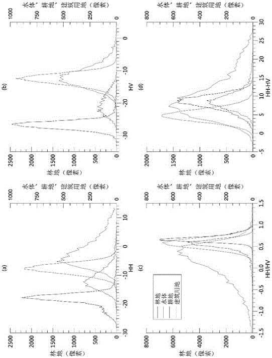
[0023] Example 1: Experimental content and conditions: 1. The 2010 PALSAR mosaic product in Danzhou, Hainan Province, the spatial resolution is 25 meters, and the DN value of the converted image is normalized radar cross-section backscatter data (sigmanaught). Forest classification is implemented using decision tree classification method.

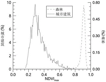
[0024] 2. A total of 39 scenes of LandsatTM / ETM+L1T data (strip number 124 / 046) from 2009 to 2010, including 18 scenes of TM and 21 scenes of ETM+, with a spatial resolution of 30 meters. Use Fmask for automatic cloud removal, LEDAPS for atmospheric correction, IDL programming to achieve NDVI maximum synthesis, and draw NDVI histograms of forest and building samples as shown figure 2 shown. Filter the PALSAR forest with the 95% quantile of building pixels 0.65 (rounded) as the boundary value.

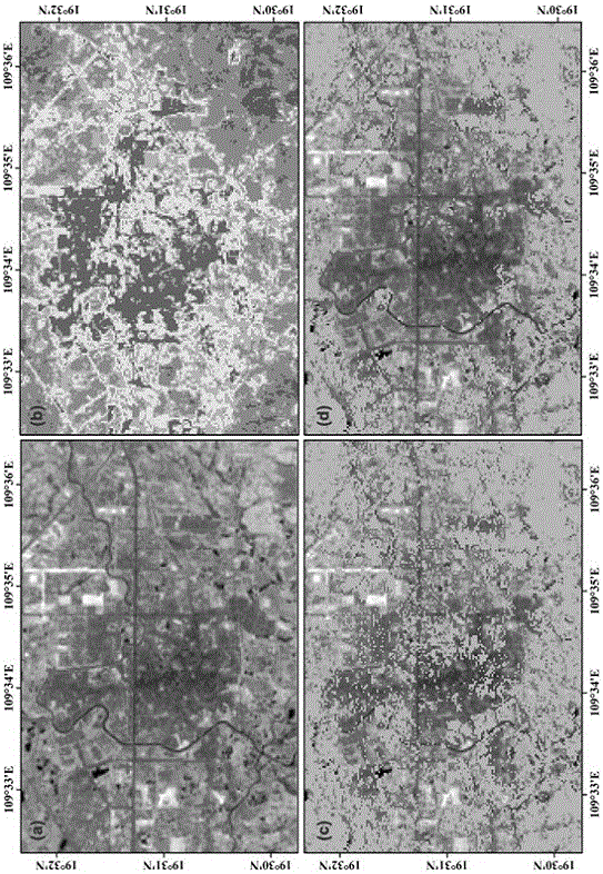
[0025] 3. The experimental results are as follows: image 3 (Schematic diagram of PALSAR forest classification results corrected by NDVI combine...


PUM


Abstract

The invention discloses a method for eliminating city building pixels in a forest classification result based on a PALSAR radar image, relating to the remote sensing image processing technology field. The method for eliminating city building pixels comprises steps of (1) extracting forest information from a PALSAR radar image, (2) finishing optical image pre-processing and calculating a normalization vegetation index NDVI, (3) performing maximum value synthesis on multiple NDVI images to obtain a cloudless NDVI product in a research area, (4) performing re-sampling on the PALSAR forest classification result or the NDVI synthesis product to realize unification of spatial resolution, (5) utilizing the ground samples of the forest and the city building to draw NDVI histograms of two surface features and determine a filtering boundary value T, and (6) performing wave band operation on the PALSA forest result after re-sampling, and filtering the forest pixels with NDVI values being lower than the boundary value T. The invention utilizes the normalization vegetation index NDVI to eliminate or reduce the city building elements of the forest classification result based on the PALSAR, and improves the forest classification result accuracy.

Description

technical field [0001] The invention relates to the technical field of remote sensing image processing, in particular to a method for eliminating urban building pixels in PALSAR-based forest classification results by using maximum value synthesis NDVI. Background technique [0002] PALSAR is an L-band synthetic aperture radar sensor carried by the ALOS satellite. It is not affected by clouds, weather, and day and night. It can observe the earth around the clock and obtain high-resolution radar data. L-band has stronger penetrating power than C, X and other radar bands, and can obtain rich spatial structure information of ground objects, especially has a good ability to identify forest vegetation, and has been widely used to extract forest information. However, due to its extremely complex structural features, urban buildings also exhibit backscatter coefficient characteristics similar to those of forests ( figure 1 ). Therefore, in the forest classification results directl...

Claims


Application Information

Patent Timeline
IPC IPC(8): G06T5/50
Inventor 不公告发明人
Owner RUBBER RES INST CHINESE ACADEMY OF TROPICAL AGRI SCI
Why Eureka
Try Eureka