Double-circle sub-template underwater terrain matching method

An underwater terrain matching and sub-template technology, which is applied in image data processing, instruments, calculations, etc., can solve the problems of long matching time and less information, and achieve the effect of solving anti-rotation, improving accuracy, and ensuring accuracy

Inactive Publication Date: 2015-12-16
SOUTHEAST UNIV
View PDF3 Cites 8 Cited by
  • Summary
  • Abstract
  • Description
  • Claims
  • Application Information

AI Technical Summary

Problems solved by technology

However, the above algorithms are either based on one-dimensional sequence matching, with less information, or have problems such as anti-

Method used


Image

  • Double-circle sub-template underwater terrain matching method
  • Double-circle sub-template underwater terrain matching method
  • Double-circle sub-template underwater terrain matching method

Examples


Embodiment Construction

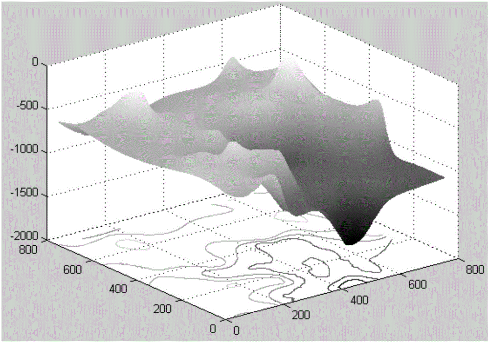
[0040] A kind of double-circle sub-template underwater terrain matching method proposed by the present invention is realized in the following specific ways: (1) the strips obtained by the multi-beam sounding system form a two-dimensional elevation array through data processing and are converted into gray values , to form a template to be matched, and convert the topographic elevation map of the original database into a grayscale image to form a search mother map; to call a certain data of the National Marine Science Database, and form a regular grid array through processing. The three-dimensional topographic map is as follows figure 1 .

[0041] The two-dimensional elevation array obtained by multi-beam bathymetric interpolation and the elevation array of the original database are grayscaled and converted into a grayscale image. The conversion method is as follows:

[0042] p i , j = ...


PUM


Abstract

The present invention provides a double-circle sub-template underwater terrain matching method. The method comprises: acquiring a strip by a multi-beam sounding system, forming a two-dimensional elevation array by means of data processing, transforming the two-dimensional elevation array into a gray-scale value, forming a to-be-matched template, calling an original database terrain elevation map, transforming the original database terrain elevation map into a gray-scale map, and forming a search mother map; selecting a relatively large template, selecting two small sub-templates as inscribed circles, determining a positional relationship between the double circles, and performing double-circle sub-map search matching on the mother map; and extracting an image corner point feature amount, matching double-circle sub-maps searched by the mother map with the sub-templates, and acquiring the position of an underwater vehicle. Compared with a conventional single template matching method, the double-circle sub-template underwater terrain matching method provided by the present invention solves the problem of excessively long traversal search matching time; and by using a circular template, the calculation complexity of a corner point feature detection algorithm can be lowered, the influence of problems such as rotation, affine transformation and the like is overcome, the matching time is shortened, the matching precision is improved, and very good generalization and applicability are achieved.

Description

technical field [0001] The invention relates to a double-circle sub-template underwater terrain matching method, which belongs to the technical field of underwater navigation. Background technique [0002] The terrain-related matching algorithm was first applied in aviation, and successfully tested in fighter jets and cruise missiles, such as the terrain-assisted navigation system developed by the British Aerospace Agency, referred to as the Terrain Profile Matching System (TERCOM); the US Sandia Laboratory The developed Sandia Terrain Aided Navigation Method (SITAN) has also been researched and developed a terrain assisted navigation system in China, and has been successfully tested on equipped weapons. [0003] The mature application of terrain matching technology at home and abroad is mainly concentrated in aviation and ground. Since the 21st century, the strategic position of marine resources in various countries has become more and more important. Underwater precise pos...

Claims


Application Information

Patent Timeline
IPC IPC(8): G06T7/00
CPCG06T7/001G06T2207/30181
Inventor 张涛胡贺庆徐晓苏杨书天
Owner SOUTHEAST UNIV
Why Eureka
Try Eureka