Distributed parallel spatial viewshed analysis method

A domain analysis and distributed technology, applied in the field of distributed parallel space visual domain analysis, can solve problems such as parallel scheduling difficulties and low data management efficiency

Active Publication Date: 2016-01-20
INST OF SOIL SCI CHINESE ACAD OF SCI
View PDF1 Cites 11 Cited by
  • Summary
  • Abstract
  • Description
  • Claims
  • Application Information

AI Technical Summary

Problems solved by technology

[0009] Aiming at the above-mentioned technical problems, the technical problem to be solved by the present invention is to provide a distributed parallel space visual domain analysis method, which can solve the existing In the distributed parallel computin

Method used


Image

  • Distributed parallel spatial viewshed analysis method
  • Distributed parallel spatial viewshed analysis method
  • Distributed parallel spatial viewshed analysis method

Examples


Example Embodiment

[0058] The specific implementation manners of the present invention will be further described in detail below in conjunction with the accompanying drawings.

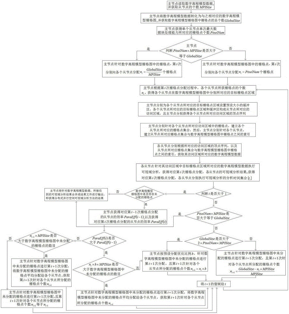
[0059] During the actual application process of the distributed parallel spatial visual domain analysis method designed by the present invention, the main classes and interfaces are shown in Table 1 below.

[0060]

[0061] Table 1

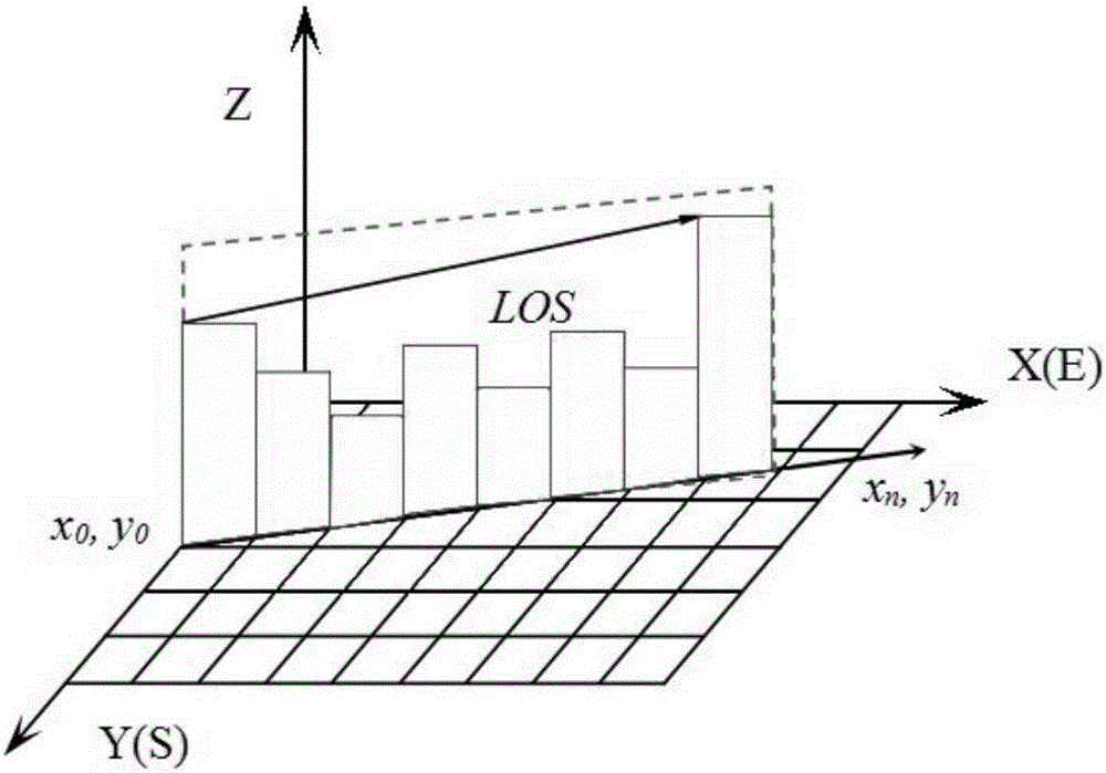
[0062] like figure 2 As shown, each grid point in the digital elevation model grid map corresponding to the digital elevation model data stores the elevation value, and the accessibility of the line of sight (LOS) from the viewpoint (x0, y0) to the target point (xn, yn) is judged If there is no obstacle in the line of sight from the viewpoint to the target point, then the two points are called visible; otherwise, they are called invisible. Therefore, calculating the visibility analysis from a fixed viewpoint to all areas is called viewable domain calculation, and this method will retur...


PUM


Abstract

The invention relates to a distributed parallel spatial viewshed analysis method. A module is subjected to parallel dynamic division by using digital elevation model data, parallelization and data scheduling of a serial algorithm are quickly completed, and irregular data partitioning and a redundancy mechanism of a sight line region are applied, so that it is ensured that a slave node can access to the digital elevation model data corresponding to a target grid point region in a distributed calculation environment, wherein an irregular data parallel policy has important guidance meaning for viewshed algorithms of different realization modes; and in combination with a buffer region mechanism, correct operations of different dependence degree algorithms are effectively ensured and resource utilization efficiency of the slave node is improved, so that the method has wide industrial application prospects.

Description

technical field [0001] The invention relates to a distributed parallel spatial visual domain analysis method, which belongs to the technical field of spatial visual domain problem analysis. Background technique [0002] Spatial visibility analysis is a common concept used to characterize whether things can be directly observed by human eyes. The terrain visibility analysis based on the digital elevation model refers to the range of terrain that can be seen from one or more positions or the degree of visibility with other terrain points. Among them, the visual domain analysis is the collection of topographic points that can be observed by the research observation point within its observation range. [0003] The data base of spatial viewshed analysis is digital elevation model (DEM). The digital elevation model is one of the most important spatial information data in the geographic information system database. It is the basic data for spatial analysis and the core data for 3...

Claims


Application Information

Patent Timeline
IPC IPC(8): G06F17/50
Inventor 宋效东张甘霖汤国安窦万峰刘峰
Owner INST OF SOIL SCI CHINESE ACAD OF SCI
Why Eureka
Try Eureka