Three-dimensional terrain model real-time smooth drawing method with combination of GPU technology

A 3D terrain and model technology, applied in the field of image processing, can solve the problems of lagging geospatial intelligence, insufficient 3D expression ability, and difficulty in meeting real-time and accurate data acquisition and visualization capabilities.

Inactive Publication Date: 2016-02-17
PLA AIR FORCE AVIATION UNIVERSITY
View PDF1 Cites 79 Cited by
  • Summary
  • Abstract
  • Description
  • Claims
  • Application Information

AI Technical Summary

Problems solved by technology

At the same time, our combat space is constantly expanding, but the development of geospatial intelligence is lagging behind. Due to the limitations of sensor technology and computer graphics technology in the early stage, data acquisition and visualization capabilities are difficult to meet real-time and accurate requirements. The processing method of the plane can simplify the process of understanding and expressing the spatial information, but at the expense of the authenticity and integrity of the spatial information, especially the elevation information and the topological relationship of the three-dimensional space
However, with the rapid development of remote sensing technology and computer graphics, it is no longer difficult to obtain high-resolution elevations and images, and efficient and realistic 3D display. The development of disciplines has also prompted military intelligence to make up for its 3D representation Insufficient technical deficiencies

Method used


Image

  • Three-dimensional terrain model real-time smooth drawing method with combination of GPU technology
  • Three-dimensional terrain model real-time smooth drawing method with combination of GPU technology
  • Three-dimensional terrain model real-time smooth drawing method with combination of GPU technology

Examples


Embodiment Construction

[0126] 1. Researched the preprocessing process of organizing and managing terrain data, starting from the projection coordinate system used by many representation models and elevations, discussed the implementation methods of projection transformation, noise elimination and interpolation sampling in turn, in order to build multi-resolution Terrain data pyramid preparation.

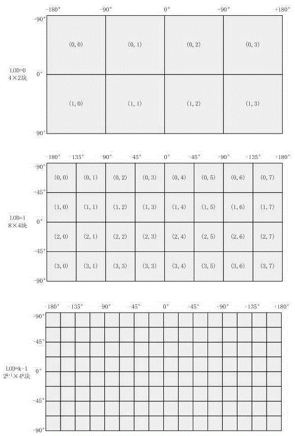
[0127] 2. Study the scheme of earth space subdivision and the data organization method of multi-resolution pyramid layered blocks, and organize and store the global multi-resolution terrain data according to the file format designed in this paper; use the quadtree structure to store each data Nodes are indexed, and a fast algorithm for updating and inserting quadtrees is proposed.

[0128] 3. Research on GPU-based 3D terrain rendering enhancement technology. Analyzed the operation and division of labor at each stage of the graphics rendering pipeline, discussed the rendering algorithm combined with terrai...


PUM


Abstract

The invention provides a three-dimensional terrain model real-time smooth drawing method with combination of a GPU technology, and belongs to the technical field of image processing. The objective of the invention is to provide the three-dimensional terrain model real-time smooth drawing method with combination of the GPU technology so that cache reuse in multiple times of drawing can be realized based on the current popular programmable GPU technology with a global digital elevation model acting as a data source, and load of computation space is effectively reduced. The method comprises the steps of construction of a multi-resolution pyramid model, elimination of image noise points, filtering of images, partitioning of planar projection of the earth according to equal latitude and longitude, and construction of different hierarchical levels of pyramid layers according to a mode from the top to the bottom. Acceleration and enhancement of terrain rendering are realized based on the programmable GPU technology, i.e. all phases of a graphical drawing pipeline are controlled by using shader languages, two and textures are respectively generated by vertex information and index information of elevation data to be stored in video memory for scheduling of whole terrain drawing; and vertex interpolation and migration are performed in the geometric phase by utilizing a curved surface subdivision and fractal technology so that procedural details are generated and the phenomenon of edges and corners of the terrain mesh when resolution is insufficient can be compensated.

Description

technical field [0001] The invention belongs to the technical field of image processing. Background technique [0002] With the increasing maturity of aerospace technology and remote sensing technology, the spatial resolution of reconnaissance satellites orbiting low-earth orbits and sensors carried on various aircrafts is constantly improving, and digital photogrammetry technology is becoming more and more precise. The data set gathered from various remote sensing data is an important information source of geospatial intelligence, and the remote sensing image and digital elevation are the foundation and foundation of the entire spatial data framework. Under the premise of rapidly increasing application demand for such basic geographic data, the amount of satellite remote sensing imagery and digital elevation data is also increasing. How to effectively manage and utilize it has become an important issue in the fields of remote sensing data processing and geographic informati...

Claims


Application Information

Patent Timeline
Patent Type & Authority Applications(China)
IPC IPC(8): G06T17/05
CPCG06T17/05
Inventor 全吉成王玉锋杨明权白新伟孙文邦王平赵柏宇候宇青阳魏湧明
Owner PLA AIR FORCE AVIATION UNIVERSITY
Why Eureka
Try Eureka