Method for removing high biomass sugar cane in PALSAR forest classification result

A technology with classification results and high biomass, applied in the field of remote sensing image processing, can solve problems such as affecting the accuracy of classification results, and achieve the effect of improving accuracy

Active Publication Date: 2016-03-09
RUBBER RES INST CHINESE ACADEMY OF TROPICAL AGRI SCI +1
View PDF6 Cites 1 Cited by
  • Summary
  • Abstract
  • Description
  • Claims
  • Application Information

AI Technical Summary

Problems solved by technology

In Guangxi, Hainan, Guangdong and other places where sugarcane is more planted, if PALSAR radar images are us

Method used


Image

  • Method for removing high biomass sugar cane in PALSAR forest classification result
  • Method for removing high biomass sugar cane in PALSAR forest classification result
  • Method for removing high biomass sugar cane in PALSAR forest classification result

Examples


Embodiment 1

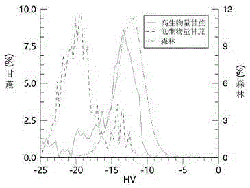
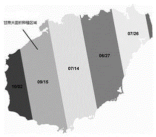
[0021] Example 1: The experimental location is the coastal area of ​​Danzhou, Hainan Province. The PALSAR radar image is a mosaic product in 2009 (with a spatial resolution of 25 meters). The acquisition time of the two strip images was September 15 and October 2, A large amount of sugarcane is planted in the coastal areas of these two strips, and sugarcane has a high biomass after mid-to-late September.

[0022] Preprocess the PALSAR image, convert the DN value of the image to normalized radar cross-section backscatter data (sigmanaught), use the decision tree classification method to realize forest classification, and resample the forest classification result to 30 meters.

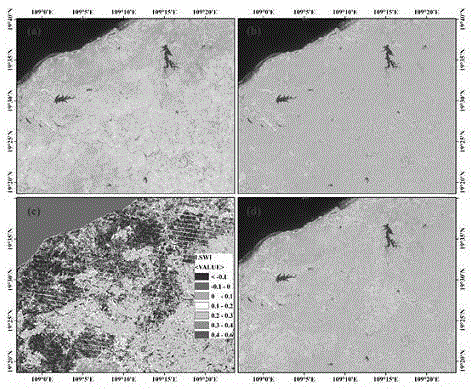
[0023] The deciduous forests in Hainan are mainly rubber forests. During the early stages of leaf defoliation and leaf extraction (January to early April), the moisture index of the forest may be lower than zero. Therefore, TM / ETM+ images (L1T) with an annual accumulation of 100-365 days in 2008-2009 wer...


PUM


Abstract

The present invention discloses a method for removing a high biomass sugar cane in a PALSAR forest classification result, relating to the technical field of remote sensing image processing. The method comprises the steps of (1) extracting forest information in PALSAR radar images by using a decision tree classification or supervision classification method, (2) selecting multiple optical remote sensing images which are close to a PALSAR radar image acquisition time and are not in a forest leaf-fall season, completing pretreatment, and calculating a moisture index LSWI, (3) carrying out minimum value integration on multiple LSWI images, and obtaining an LSWI product without cloud in a research area, (4) carrying out resampling on a PALSAR forest classification result or the LSWI product, realizing the unification of spatial resolution, (5) carrying out band operation on the resampled PALSAR forest result, and filtering the forest image element whose LSWI value is lower than zero. The forest classification accuracy is improved.

Description

technical field [0001] The invention relates to the technical field of remote sensing image processing, in particular to a method for removing sugarcane with high biomass in PALSAR forest classification results. Background technique [0002] PALSAR is an L-band synthetic aperture radar sensor carried by the ALOS satellite. It is not affected by clouds, weather, and day and night. It can observe the earth around the clock and obtain high-resolution radar data. L-band has stronger penetrating power than C, X and other radar bands, and can obtain rich spatial structure information of ground objects, especially has a good ability to identify forest vegetation, and has been widely used to extract forest information. Sugarcane with high biomass will show a backscatter coefficient characteristic very similar to forest ( figure 1 ), if the acquisition time of the PALSAR radar images used for classification happens to be during the period of high sugarcane biomass, sugarcane will be...

Claims


Application Information

Patent Timeline
IPC IPC(8): G01S13/90
CPCG01S13/90G01S13/9027
Inventor 不公告发明人
Owner RUBBER RES INST CHINESE ACADEMY OF TROPICAL AGRI SCI
Why Eureka
Try Eureka