Tree point cloud three-dimensional reconstruction method based on local structure and direction perception

A technology of local structure and orientation awareness, applied in the field of spatial information, it can solve the problems of skeleton geometric topology correlation distortion, high noise of measurement data, missing point cloud, etc.

Inactive Publication Date: 2016-03-16
BEIJING NORMAL UNIVERSITY
View PDF6 Cites 18 Cited by
  • Summary
  • Abstract
  • Description
  • Claims
  • Application Information

AI Technical Summary

Problems solved by technology

[0003] Due to the limitation of measurement conditions, the measurement data often has high noise, and the complexity of the surrounding scene objects also determines that the occlusion during the measurement process is inevitable, so the measured data is usually incomplete, and some point clouds are missing. In addition, trees generally have complex three-dimensional structures, topological relationships, and rich details, which determines that the reconstruction of ground lidar tree point clouds based on single-di...

Method used


Image

  • Tree point cloud three-dimensional reconstruction method based on local structure and direction perception
  • Tree point cloud three-dimensional reconstruction method based on local structure and direction perception
  • Tree point cloud three-dimensional reconstruction method based on local structure and direction perception

Examples


Embodiment 1

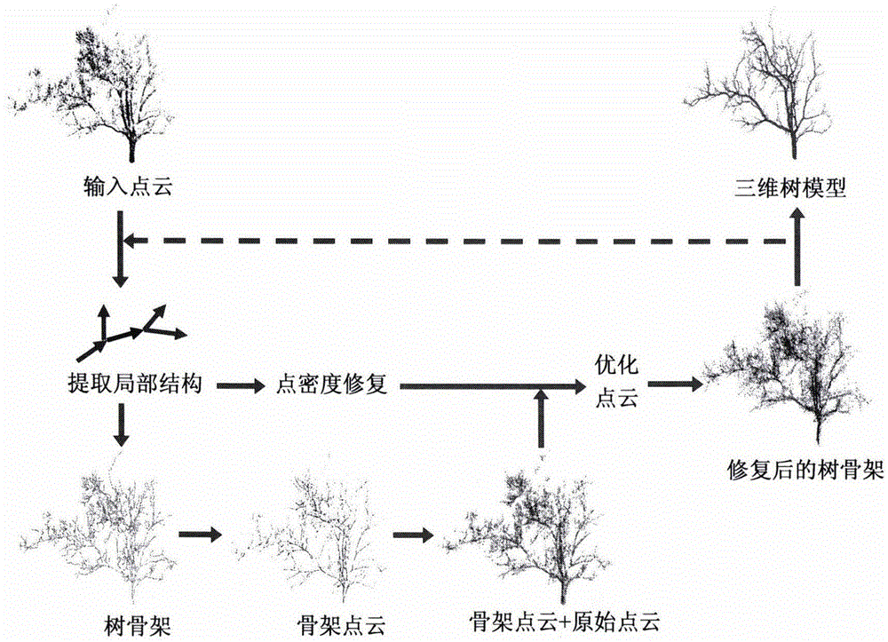
[0117] Using RIEGLLMS-Z620 terrestrial lidar scanner to obtain tree point cloud by single-station scanning, the vertical resolution and horizontal resolution during scanning are both 0.057°, the distance between the scene trees and the scanner is different, the distant trees are covered by the front Blocking by ground objects, resulting in missing data and uneven point density. The above tree point cloud was 3D modeled on an InterCore(TM) i7-4790 3.6GHZ computer with 4GB of memory.

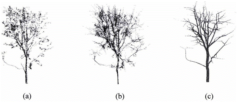
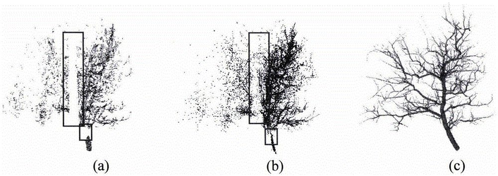
[0118] figure 2 (a) is the point cloud data of a tree that is closer to the scanner. The point density of the tree is higher, but the branches of the canopy are more and slender. Self-occlusion causes a jump in the point density of the local area, and the The point cloud on one side of the scanner is extremely sparse. figure 2 (b) is the new point cloud data after repairing the original point cloud, from which the 3D model of the tree is reconstructed ( figure 2 c). From figure 2 (c) It c...


PUM


Abstract

The invention realizes a tree point cloud three-dimensional reconstruction method based on a local structure and direction perception, and belongs to the technical field of space information. Considering the continuous characteristic of the branch direction and the point cloud density in the local structure, the method deduces a connecting relation of branches at a data missing position, an optimization equation and the iteration process of point cloud repair are designed, points in point cloud data are driven to contract and diffuse in the same time along the direction of a skeleton line by employing skeleton point cloud, the optimized point cloud does not produce extra noises, the contracted skeleton is employed to inherit the space association between adjacent iterations instead of depending on the optimized point cloud, and structural information of the original point cloud is fully retained. The radius of each node of the skeleton is calculated by employing a plant growth model, and the skeleton is expanded to a three-dimensional tree model according to the radius of each node. Compared with the conventional tree three-dimensional reconstruction method, point cloud of a deletion region can be more accurately repaired, and a better modeling result is obtained.

Description

1. Technical field [0001] The invention relates to a tree point cloud reconstruction method based on local structure and direction perception, and belongs to the field of spatial information technology. 2. Background technology [0002] In recent years, lidar technology has developed rapidly. Through high-speed laser scanning measurement, it can quickly obtain three-dimensional coordinate data of a large area of ​​the measured object surface with high precision, and has become an important means to quickly obtain fine and large-scale three-dimensional urban scene data. Ground-based lidar is a non-destructive high-resolution three-dimensional measurement method, which can make up for the shortcomings of existing observation methods, realize the automatic acquisition of geometric structure parameters such as vegetation, and provide the possibility to reconstruct the real three-dimensional structure of trees. [0003] Due to the limitation of measurement conditions, the measure...

Claims


Application Information

Patent Timeline
IPC IPC(8): G06T17/00
CPCG06T17/00
Inventor 张立强王臻
Owner BEIJING NORMAL UNIVERSITY
Why Eureka
Try Eureka