GNSS and laser range finding combination measurement system and method

A laser ranging and measurement system technology, applied in the field of surveying and mapping, can solve the problems of high cost, high cost of total station, and low cost performance

Inactive Publication Date: 2016-03-30
WUHAN UNIV
View PDF6 Cites 15 Cited by
  • Summary
  • Abstract
  • Description
  • Claims
  • Application Information

AI Technical Summary

Problems solved by technology

The disadvantages of this method are: 1) the total station is relatively bulky and needs to be equipped with a tripod, which is inconvenient to carry; 2) the centering and leveling operation of the total station is time-consuming; 3) the two known points must be in sight, But the distance should not be too close, otherwise the orientation error will be very large; 4) The cost of the total station is relatively high, and the price is usually tens of thousands of yuan
The laser rangefinder that can provide angle observation value is different from the ordinary handheld laser rangefinder. It is essentially a handheld total station, such as TrimbleLaserAce1000, laicaDISTO. The disadvantages are: 1) The built-in gravity sensor (or electronic compass) , gyroscope, MEMS), there is an included angle between the north direction and the north direction of the geographical coordinates (in China, the north direction of the central meridian of the Gaussian projection). Therefore, on-site orientation and correction are required, which greatly weakens its convenience; 2) Even if the system error is e...

Method used


Image

  • GNSS and laser range finding combination measurement system and method
  • GNSS and laser range finding combination measurement system and method
  • GNSS and laser range finding combination measurement system and method

Examples


Embodiment Construction

[0046] specific implementation plan

[0047] Now in conjunction with the accompanying drawings, several preferred solutions obtained according to the present invention will be described in detail.

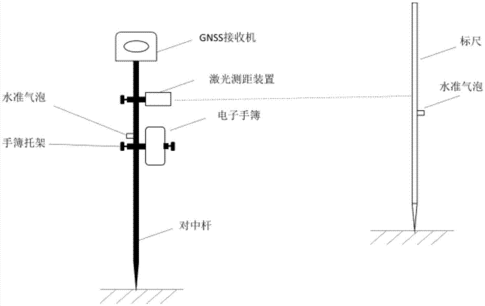
[0048] First embodiment of the present invention utilizes existing equipment as far as possible, it is combined as figure 1 The measurement system shown. The GNSS receiver, shown in the attached figure is an illustration of a certain integrated machine. In actual use, any geodesic integrated machine or split machine on the market can be used, such as the R8 produced by Trimble in the United States. The controller can use the matching TSC2 controller. The centering rod can use the 2.2m carbon fiber stretchable insulated centering rod produced by China Southern Company, and the centering rod bracket can be further selected so that the centering rod can be quickly leveled and kept stable. The laser rangefinder can choose any product with millimeter-level ranging accuracy, such as t...


PUM


Abstract

The invention discloses a GNSS and laser range finding combination measurement system and method when a to-be-positioned point cannot be determined through a GNSS method. The device is low in cost, is portable, and is simple and easy in scheme. The device just needs to provide a distance observation value, and gets rid of the dependence on azimuth and angle observation value. The range can be hundreds of meters, and the device can achieve the quick operation at a plurality of known points. The device can carry out measurement at two points (at least), and finally can obtain the optimal solution to the coordinates of the to-be-positioned point through Least Square and reasonable weighting. The system and method iron out the defects in the prior art, and is good in application prospect.

Description

technical field [0001] The invention belongs to the field of surveying and mapping, and in particular relates to a measurement system and a measurement method combining GNSS and laser ranging. Background technique [0002] GNSS (Global Satellite Navigation System) is the collective name of various satellite positioning systems such as GPS, GLONASS, and BDS. Due to its all-weather, all-time, wide coverage, and high-precision characteristics, it is currently widely used in the field of surveying and mapping. GNSS measurement includes static and dynamic operation methods; among them, dynamic measurement such as RTK (real-time dynamic measurement) or PPK (post-processing dynamic measurement) mode can achieve centimeter-level positioning accuracy. GNSS dynamic survey is usually equipped with a centering pole to achieve rapid centering leveling and movement, which is especially convenient when carrying out cadastral surveying, topographic map surveying and other work. However, if...

Claims


Application Information

Patent Timeline
IPC IPC(8): G01S19/45
CPCG01S19/45
Inventor 章迪邹进贵向东花向红罗喻真张万威
Owner WUHAN UNIV
Why Eureka
Try Eureka