Traffic conflict prediction method based on space-time proximity

A traffic conflict and prediction method technology, applied in the direction of prediction, instrumentation, data processing applications, etc., can solve problems such as insufficient basic data, and achieve the effect of improving the level of safety services, significant measurability and practicability

Inactive Publication Date: 2016-04-06
HARBIN INST OF TECH
View PDF0 Cites 10 Cited by
  • Summary
  • Abstract
  • Description
  • Claims
  • Application Information

AI Technical Summary

Problems solved by technology

[0012] The present invention aims at the limitations of existing road traffic accident prediction methods, in order to avoid the problem of insufficient basic data of the prediction method based on statistical traffic accident data, and further proposes a traffic conflict prediction method based on temporal and spatial proximity

Method used


Image

  • Traffic conflict prediction method based on space-time proximity
  • Traffic conflict prediction method based on space-time proximity
  • Traffic conflict prediction method based on space-time proximity

Examples


specific Embodiment approach 1

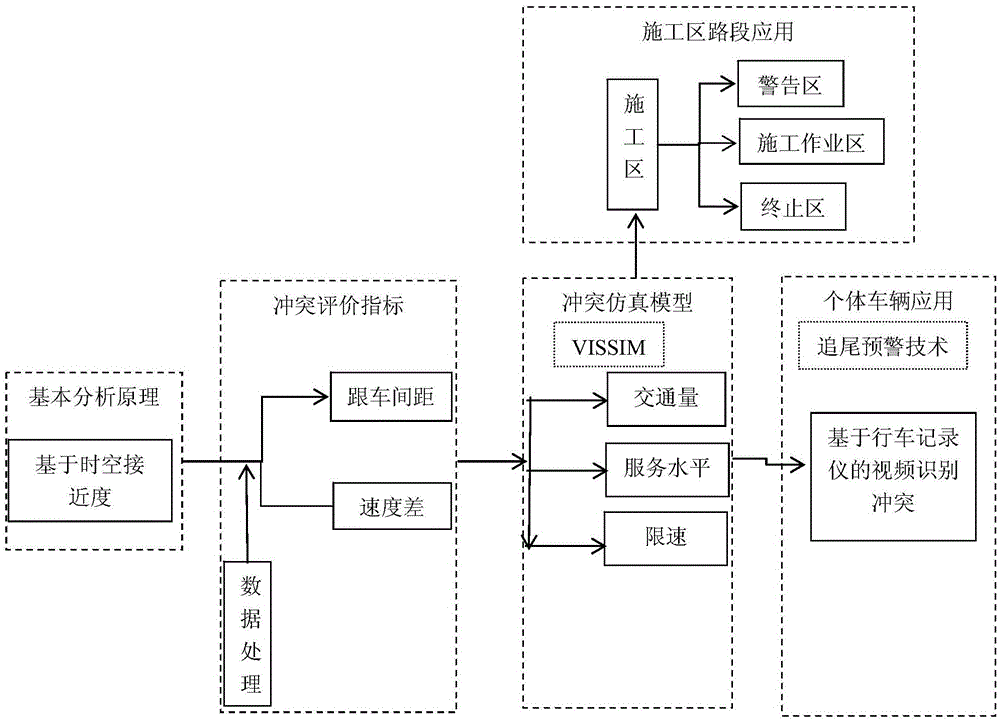
[0041] Specific Embodiment 1: A traffic conflict prediction method based on spatio-temporal proximity in this embodiment is implemented according to the following steps:

[0042] Step 1. Based on the space-time proximity, the speed difference and the following distance are used as the two-dimensional evaluation indicators of the conflict severity;

[0043] Step 2. Determine the severity of the conflict according to the two-dimensional evaluation indicators of the following distance and the speed difference;

[0044] Step 3. According to the two-dimensional conflict evaluation index and the determined data of the actual construction area, use the VISSIM simulation software to construct a conflict simulation model, and simulate the traffic flow operation of the construction road section;

[0045] Step 4. According to the simulation results, the traffic conflict prediction based on the space-time proximity is obtained;

[0046] Step 41. Prediction of traffic conflicts based on spa...

specific Embodiment approach 2

[0048] Specific embodiment two: the difference between this embodiment and specific embodiment one is: according to the two-dimensional evaluation index of the following distance and the speed difference described in step two, the determination of the severity of the conflict is realized according to the following steps:

[0049] Step 21, collecting the data of the target road construction area section according to the two-dimensional evaluation index;

[0050] Collect the data of the target road construction area section, obtain the number of conflicts in the construction section, the distribution of the speed difference between the vehicles that constitute the conflict, and the distribution of the following distance, obtain the cumulative frequency distribution curve of the following distance and speed difference, and determine the seriousness of the conflict The threshold value of the degree, in which, the following distance of the accumulative frequency of the following dis...

specific Embodiment approach 3

[0052] Specific embodiment three: what this embodiment is different from specific embodiment one or two is: the data of the collection target road construction zone road section described in step 21, the construction zone road section data comprises the speed limit rule of the construction zone road section, the construction zone road section Length, number of lanes, traffic volume, traffic composition, following distance and speed;

[0053] Among them, the speed limit rules of the road section in the construction area include the speed limit and the position of the speed limit sign on the normal road section in front of the construction area, and the position of the speed limit sign canceled in the termination area; the length of the road section in the construction area includes the length of the warning area, the length of the upstream transition area, the length of the buffer zone, The length of the working area, the length of the downstream transition area, and the length ...


PUM


Abstract

The invention discloses a traffic conflict prediction method based on space-time proximity, which belongs to the technical field of road traffic safety prediction. In view of limitations of the existing road traffic accident prediction method, in order to avoid the problem that the prediction method based on traffic accident data statistics does not have sufficient basic data, the traffic conflict prediction method based on space-time proximity is thus brought forward. The method comprises the following steps: 1, based on the space-time proximity, a speed difference and a vehicle-following distance serve as conflict severity two-dimensional evaluation indexes; 2, according to the two-dimensional evaluation indexes of the vehicle-following distance and the speed difference, the conflict severity is determined; 3, according to the two-dimensional conflict evaluation indexes and the determined actually-measured construction area data, VISSIM simulation software is applied to building a conflict simulation model, and the traffic flow operation condition in the construction road section is simulated; and 4, according to the simulation result, the traffic conflict prediction based on the space-time proximity is obtained. The method of the invention is used for traffic conflict prediction.

Description

technical field [0001] The invention belongs to the technical field of road traffic safety prediction, and in particular relates to a traffic conflict prediction method based on time-space proximity. Background technique [0002] Road transportation has a wide range of applications, is flexible and can realize door-to-door transportation. Road transportation plays a huge role in comprehensive transportation, and road traffic volume occupies a relatively high proportion of the total traffic volume. In recent years, the expressway mileage has increased rapidly, which has greatly promoted the development of the national economy and society, but at the same time it has also brought many negative effects, the most important of which is traffic accidents. The increase of expressway traffic accidents poses a great threat to human life and property. Frequent accidents are one of the main problems that plague road managers and users in the process of expressway construction and maint...

Claims


Application Information

Patent Timeline
Patent Type & Authority Applications(China)
IPC IPC(8): G06Q10/04G06Q50/30
CPCG06Q10/04G06Q50/30
Inventor 孟祥海覃薇何莎莉蒋艳辉
Owner HARBIN INST OF TECH
Why Eureka
Try Eureka