Inertial navigation/Doppler radar combination-based vehicle positioning and orientation method

A Doppler radar, positioning and orientation technology, applied in the field of vehicle positioning and orientation based on inertial navigation/Doppler radar combination, can solve problems such as low positioning accuracy

Active Publication Date: 2016-04-20
四川航浩科技有限公司
View PDF4 Cites 22 Cited by
  • Summary
  • Abstract
  • Description
  • Claims
  • Application Information

AI Technical Summary

Problems solved by technology

[0003] In order to overcome the deficiency of low positioning accuracy of existing vehicle-mounted positioning and orientation methods, the present invention provides a vehicle-mounted positioning and orientation method based on inertial navigation / Doppler radar combination

Method used


Image

  • Inertial navigation/Doppler radar combination-based vehicle positioning and orientation method
  • Inertial navigation/Doppler radar combination-based vehicle positioning and orientation method
  • Inertial navigation/Doppler radar combination-based vehicle positioning and orientation method

Examples


Embodiment Construction

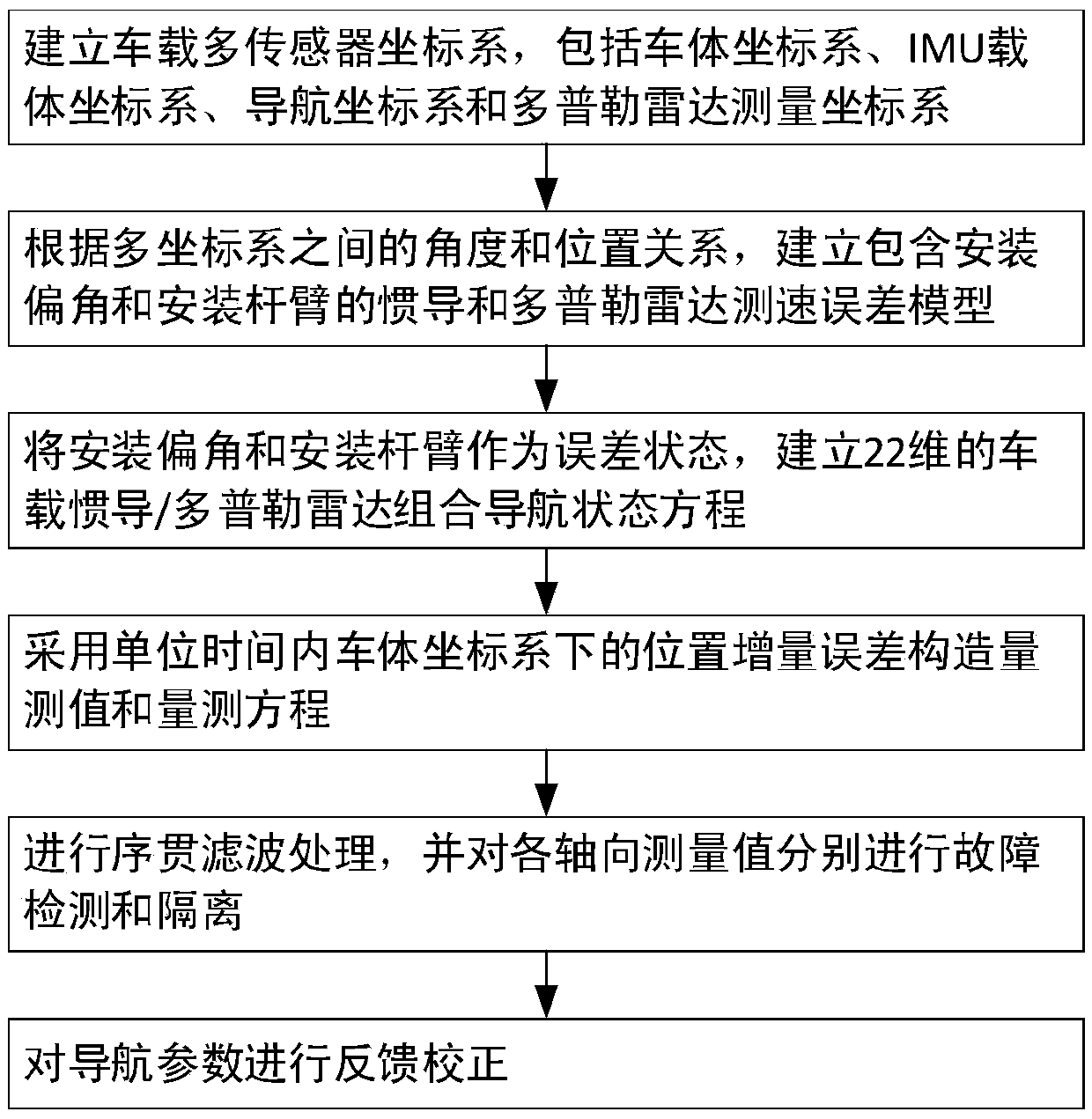
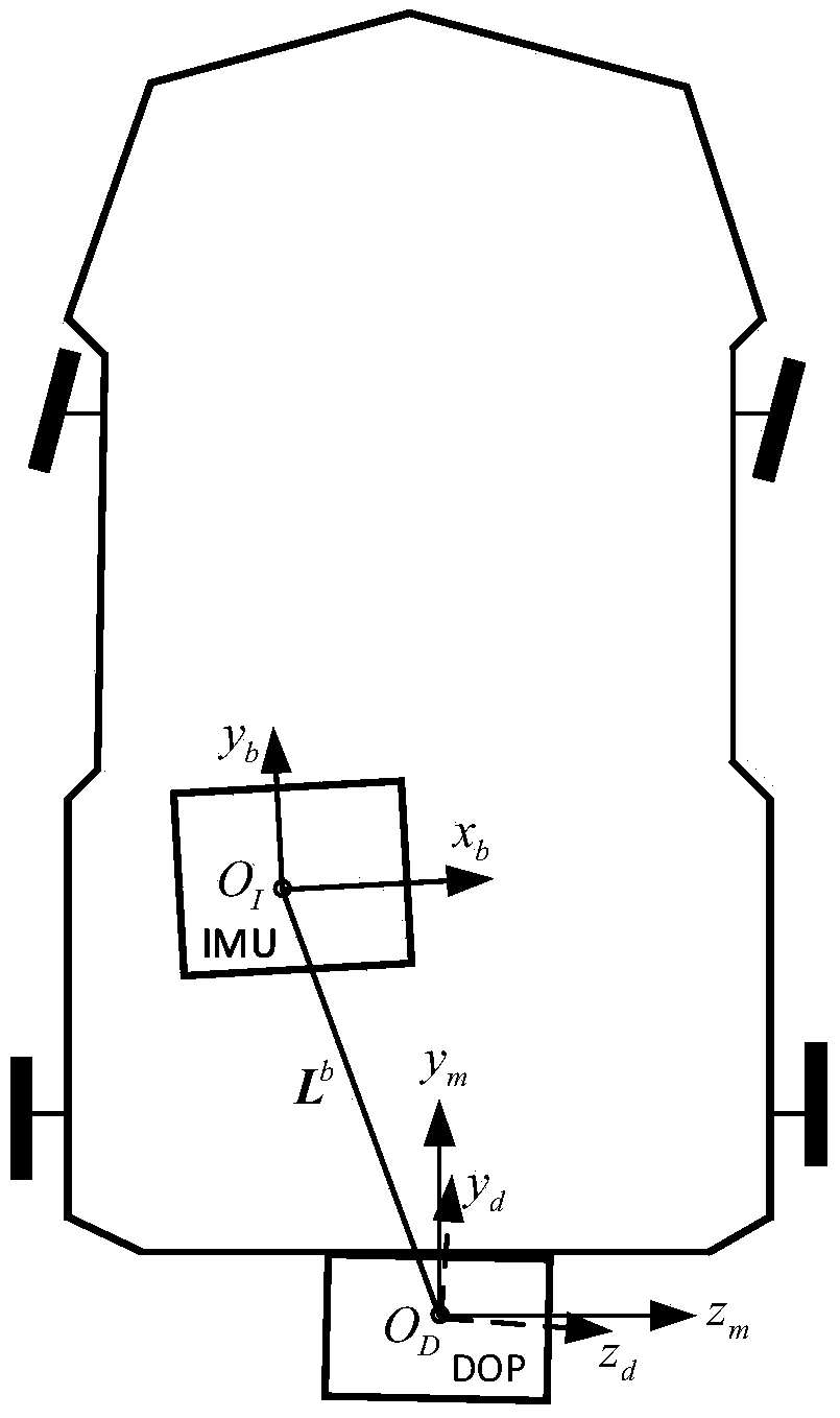
[0081] refer to Figure 1-4 . The specific steps of the vehicle positioning and orientation method based on inertial navigation / Doppler radar combination of the present invention are as follows:

[0082] 1. Establish a coordinate system.

[0083] Define the IMU carrier coordinate system as b, and the origin is located at the sensitive center O inside the IMU I , the coordinate axis pointing is determined according to the right-front-up direction.

[0084] Define the navigation coordinate system of the inertial navigation solution as n, and the origin is located at the sensitive center O inside the IMU I The geographic location of the point, and the coordinate axis is defined by the east-north-sky direction of the local geographic location.

[0085] Define the Doppler radar measurement coordinate system as d, and the origin is located at the sensitive center O of the Doppler radar D , the coordinate axis pointing is determined according to the right-front-up direction.

...


PUM


Abstract

The invention discloses an inertial navigation/Doppler radar combination-based vehicle positioning and orientation method, and aims to solve a technical problem that a conventional vehicle positioning and orientation method is low in positioning precision. According to the technical scheme, own errors of serial inertial navigation system (SINS) and Doppler radar (DOP) as well as installation error coefficients and installation level arms of the inertial navigation system and the Doppler radar on a vehicle used as state variables and position increment errors below a vehicle body coordinate system in unit time used as a measured manner are adopted to perform sequential filtering and fault detection isolation on non-integrity constraint and Doppler radar speed measurement respectively, so that the environmental adaptability of an integrated navigation system is improved, the long-time and remote working ability of the system is ensured, and the navigation positioning precision is improved. Tests show that under the condition if the working hours and the travel distance are greater than those in the background art, the positioning precision can be still significantly improved, and the maximum horizontal positioning error decreases from 120 m to 30 m.

Description

technical field [0001] The invention relates to a vehicle positioning and orientation method, in particular to a vehicle positioning and orientation method based on inertial navigation / Doppler radar combination. Background technique [0002] The document "Apositioning and orientation method based on the usage of INSands single-beam Lidar, Optik-International Journal for Light and Electron Optics, 2015, Vol126(22), p3376-3381" discloses a method of using inertial navigation / Doppler radar integrated navigation to realize vehicle positioning and orientation. Method Firstly, the reference coordinate system of inertial measurement unit (IMU), vehicle body and Doppler radar is defined, and an independent calibration method for installation deviation angle and other errors is given. At the same time, the error model of Doppler radar is established according to the reference coordinate system and the measurement model, and the Kalman filter method is used to realize the integrated n...

Claims


Application Information

Patent Timeline
Patent Type & Authority Applications(China)
IPC IPC(8): G01C21/16G01S13/86
CPCG01C21/165G01S13/86
Inventor 付强文秦永元严恭敏梅春波翁浚崔潇李四海刘洋
Owner 四川航浩科技有限公司
Why Eureka
Try Eureka