A Navigation Method for Mars Capture Section Combining Astronomical Velocimetry and Ground Radio

A Mars capture and navigation method technology, applied in the direction of integrated navigators, etc., can solve the problems that cannot meet the needs of continuous autonomy and real-time high-precision navigation in deep space exploration, and achieve the effect of clear steps

Active Publication Date: 2018-02-06
SHANGHAI SATELLITE ENG INST
View PDF4 Cites 2 Cited by
  • Summary
  • Abstract
  • Description
  • Claims
  • Application Information

AI Technical Summary

Problems solved by technology

Constrained by visible arcs and radio time delays, ground radio navigation can no longer meet the continuous, autonomous, real-time and high-precision navigation requirements of deep space exploration.

Method used


Image

  • A Navigation Method for Mars Capture Section Combining Astronomical Velocimetry and Ground Radio
  • A Navigation Method for Mars Capture Section Combining Astronomical Velocimetry and Ground Radio
  • A Navigation Method for Mars Capture Section Combining Astronomical Velocimetry and Ground Radio

Examples


Embodiment Construction

[0019] The present invention will be described in detail below in conjunction with specific embodiments. The following examples will help those skilled in the art to further understand the present invention, but do not limit the present invention in any form. It should be noted that those skilled in the art can make several modifications and improvements without departing from the concept of the present invention. These all belong to the protection scope of the present invention.

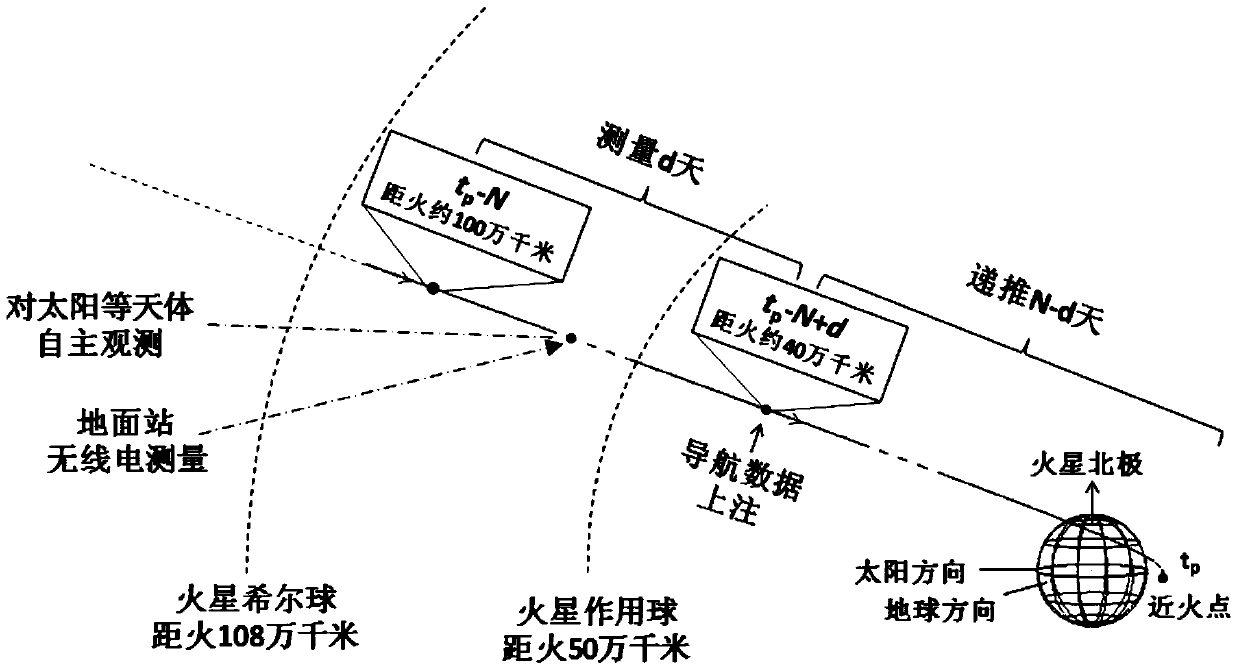
[0020] figure 1 As shown, the Mars capturing section navigation method combined with astronomical speed measurement and terrestrial radio provided by the present invention starts to implement continuous d-day navigation observations until N days before arriving at the Mars near-fire point, and stops until N-d days before arriving at Mars (wherein N Generally, it is 4-8, and d generally takes a value of 2-3). figure 1 Among them, tp is the moment when the detector brakes near fire. The probe grad...


PUM


Abstract

The present invention provides a navigation method for the Mars capture section combining astronomical speed measurement and ground radio, comprising the following steps: the ground station obtains the distance between the detector and the ground through radio ranging; the ground station obtains the detection distance through radio Doppler speed measurement. The radial velocity between the detector and the ground station; the detector obtains the radial velocity between the detector and a certain star through the autonomous speed measurement and navigation sensor; through the extended Kalman filter, the position and velocity estimation of the space-ground integrated navigation are obtained. Compared with the navigation only relying on the ground radio, the method of the invention adds the independent astronomical speed measurement observation of the detector, which can effectively improve the navigation accuracy.

Description

technical field [0001] The invention relates to a deep-space integrated navigation method, in particular to a navigation method for Mars capture segment combining astronomical speed measurement and ground radio. Background technique [0002] Deep space exploration missions put forward higher requirements on the navigation capabilities of spacecraft. Currently, ground-based radios are still the primary means of accomplishing deep-space navigation missions. Constrained by visible arcs and radio time delays, ground radio navigation has been unable to meet the continuous, autonomous, real-time and high-precision navigation requirements of deep space exploration. For this reason, scholars at home and abroad have proposed deep space astronomical autonomous navigation methods, which are mainly divided into three categories: angle measurement, distance measurement and speed measurement. Among them, speed measurement navigation is an emerging autonomous navigation method in recent ...

Claims


Application Information

Patent Timeline
Patent Type & Authority Patents(China)
IPC IPC(8): G01C21/24
CPCG01C21/24
Inventor 张伟尤伟陈晓张嵬杜洋
Owner SHANGHAI SATELLITE ENG INST
Why Eureka
Try Eureka