Panorama image acquisition system, and apparatus and method for measuring skyline based on the same

A panoramic image and acquisition system technology, applied in measuring devices, TV system components, photogrammetry/video metrology, etc., to achieve high precision, fast speed, and high integration

Active Publication Date: 2016-04-20
RES CENT FOR ECO ENVIRONMENTAL SCI THE CHINESE ACAD OF SCI
View PDF7 Cites 15 Cited by
  • Summary
  • Abstract
  • Description
  • Claims
  • Application Information

AI Technical Summary

Problems solved by technology

Due to the different shooting parameters and observation points of different photos, this method is not suitable for the rapid extraction of multi-observation point skyline contours in different cities and different observation angles, especially for batch processing of large-scale multi-point observation data sources

Method used


Image

  • Panorama image acquisition system, and apparatus and method for measuring skyline based on the same
  • Panorama image acquisition system, and apparatus and method for measuring skyline based on the same
  • Panorama image acquisition system, and apparatus and method for measuring skyline based on the same

Examples


Embodiment Construction

[0033] In order to make the object, technical solution and advantages of the present invention clearer, the present invention will be further described in detail below in conjunction with specific embodiments and with reference to the accompanying drawings.

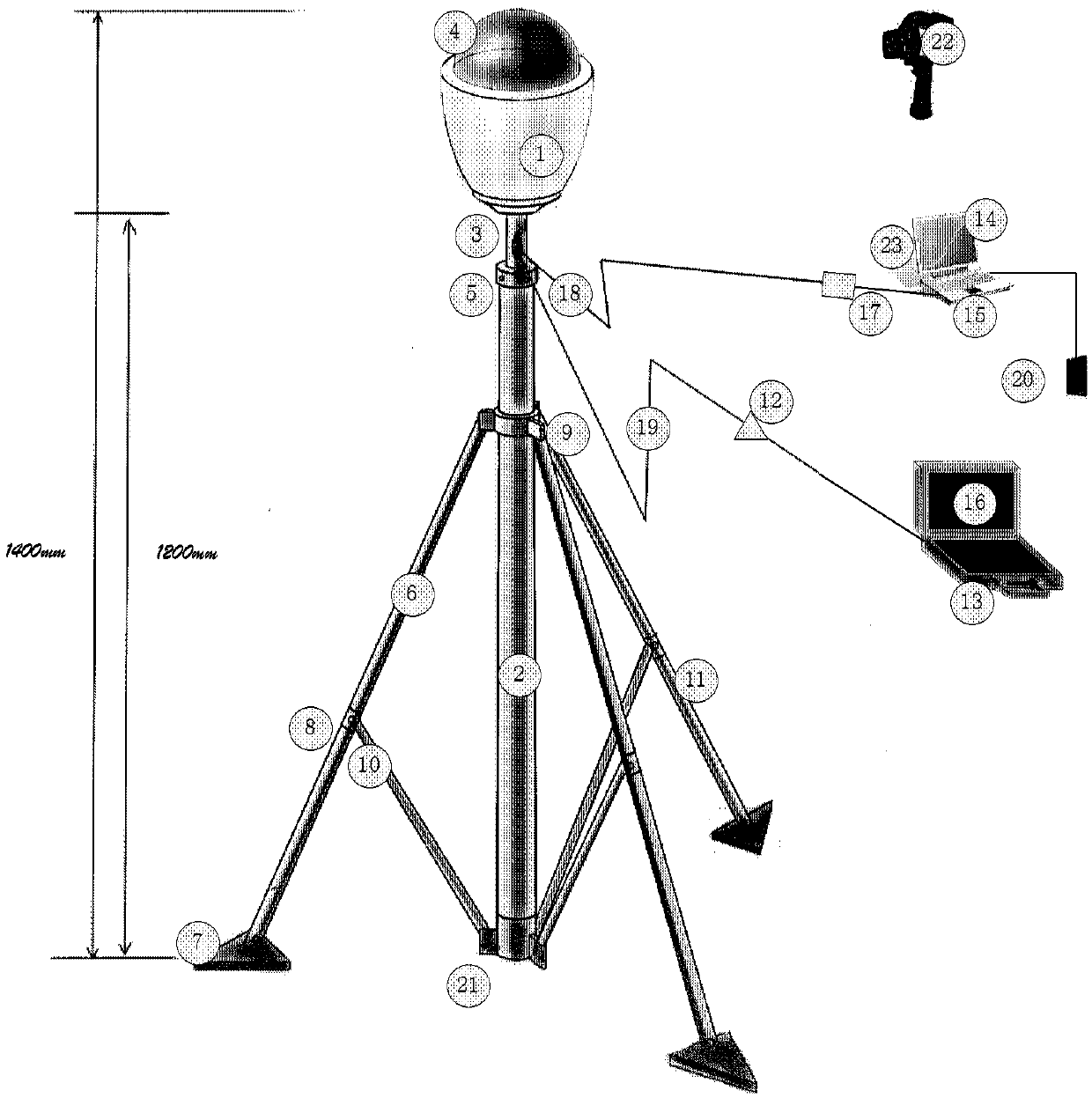
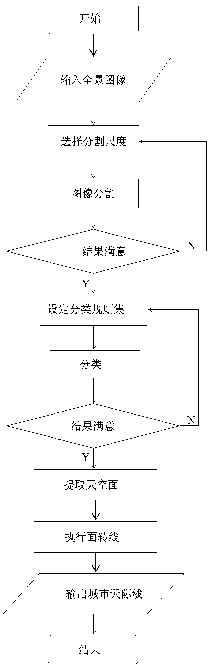
[0034] The invention discloses a brand-new method for quantitatively evaluating the city skyline based on a 360-degree panoramic image system. Its technical field belongs to G01C11 / 00 photogrammetry according to the International Patent Classification (IPC), but the main problem to be solved should belong to Urban planning, urban design or urban landscape geography. It can be said that this is a set of application of modern panoramic imaging technology, which abandons the shortcomings of individual subjectivity, random layout or partial observation in traditional methods, and innovatively conducts objective, scientific, all-angle and quantitative measurement of the skyline in the field of urban geographical landscape. com...


PUM


Abstract

The invention relates to a panorama image acquisition system, and an apparatus and method for measuring a skyline based on the same. Quantitative shooting measurement is carried out on a skyline in an urban geographical landscape field in an innovative mode; and the invention aims at measuring a 360-degree urban skyline contour of surrounding urban space building entities at the human vision level in a fixed-point, positioning, and quantitative mode by using an observer as a center. The panorama image acquisition system includes a panorama image collection unit, a moving support, and a storage and / or data sending unit. The panorama image collection unit is used for collecting a 360-degree panorama static or dynamic image; the moving support is used for supporting the panorama image collection unit; and the storage and / or data sending unit is used for storing the image collected by the panorama image collection unit or sending the image collected by the panorama image collection unit to a matched receiving unit. The provided method and apparatus have characteristics of convenient base station erection, low cost, high precision, fast speed, convenient data acquisition, and high reliability and the like.

Description

technical field [0001] The invention relates to the technical field of digital photogrammetry, and more particularly to a panoramic image acquisition system, a device and a method for measuring skyline based on the system. Background technique [0002] The city skyline is a contour line composed of a building or a group of buildings and other objects with the sky as the background, and it is a two-dimensional projection of the superimposed three-dimensional urban form. The city skyline shows people a vast skyline landscape (mostly panoramic landscapes that can be looked around), or a partial landscape composed of many skyscrapers. As an important symbol of the image of a modern city, the city skyline is one of the main criteria for urban form control. [0003] In modern urban planning, more and more attention is paid to the urban impression left by the city skyline, and at the same time, attention is paid to avoiding the incongruous modern style buildings around when protec...

Claims


Application Information

Patent Timeline
Patent Type & Authority Applications(China)
IPC IPC(8): H04N5/232G01C11/00G01C11/02
CPCG01C11/00G01C11/02H04N23/698
Inventor 董仁才李思远赵景柱张永霖付晓吴钢
Owner RES CENT FOR ECO ENVIRONMENTAL SCI THE CHINESE ACAD OF SCI
Why Eureka
Try Eureka