Imaging simulation method and system for decimeter-scale satellite-borne TDI CCD stereoscopic mapping camera

A technology of a stereo mapping camera and a simulation method, applied in the field of satellite imaging simulation

Active Publication Date: 2016-04-27
自然资源部国土卫星遥感应用中心
View PDF3 Cites 21 Cited by
  • Summary
  • Abstract
  • Description
  • Claims
  • Application Information

AI Technical Summary

Problems solved by technology

Both aspects are difficult to model with high accuracy using a single ground geometry and radiation model

Method used


Image

  • Imaging simulation method and system for decimeter-scale satellite-borne TDI CCD stereoscopic mapping camera
  • Imaging simulation method and system for decimeter-scale satellite-borne TDI CCD stereoscopic mapping camera
  • Imaging simulation method and system for decimeter-scale satellite-borne TDI CCD stereoscopic mapping camera

Examples


Embodiment Construction

[0112] The present invention will be described more fully below with reference to the accompanying drawings, in which exemplary embodiments of the present invention are illustrated.

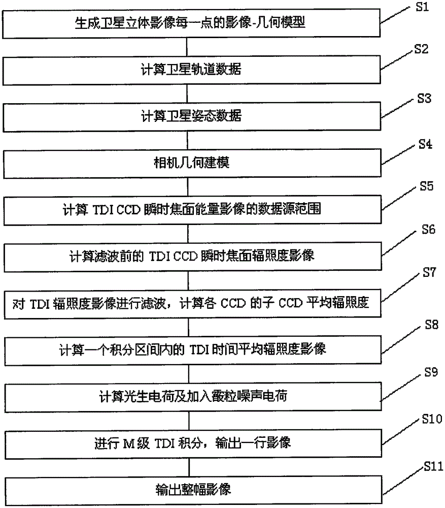
[0113] Such as figure 1 As shown, a decimeter-level satellite-borne TDICCD stereo mapping camera imaging simulation method is characterized in that it includes the following steps:

[0114] Step S1: Acquire basic data, and preprocess the basic data to generate an image-geometric model of each point of the satellite stereo image.

[0115] According to the embodiment of the present invention, the basic data is obtained by importing data, and the imported basic data is Worldview-3 satellite stereo image and auxiliary RPC (Rational Polynomial Coefficient) parameters. The present invention uses Worldview-3 satellite three-dimensional image data because the Worldview-3 satellite three-dimensional image has the highest resolution among the current commercial three-dimensional surveying and mapping satellite i...


PUM


Abstract

The invention discloses an imaging simulation method and system for a decimeter-scale satellite-borne TDI CCD stereoscopic mapping camera. Stereoscopic images of a commercial satellite Worldview-3 which has the highest resolution at present as a data source, and a data form of image+ground point is formed through stereoscopic matching processing. To acquire the instant imaging face irradiance of a TDI CCD is regarded as a core step, an orbit, attitude parameters, camera installation parameters, TDI CCD geometric parameters, camera MTF and the like are organically linked up. The multistage dynamic integral simulation of the TDI CCD is achieved through time domain integral and TDI CCD multistage charge accumulation, and then, the strict simulation of radiation response and linear array image imaging of the camera are achieved. According to the method and the system, the disadvantage in the traditional imaging simulation that the difference of geometric and radiation information corresponding to different vision angles in high-resolution satellite stereoscopic imaging is hard to simulate due to the adopting of a single data source can be avoided, and the accuracy of simulating stereoscopic mapping satellite images is improved.

Description

Technical field [0001] The invention relates to the technical field of satellite imaging simulation, in particular to a decimeter-level satellite-borne TDICCD stereo surveying and mapping camera imaging simulation method and system. Background technique [0002] With the successful launch of my country's first civil transmission-type three-dimensional surveying and mapping satellite Resource No. 3, my country's past history of relying solely on foreign high-resolution image data has ended. A large number of experiments have proved that both the resolution capability and geometric accuracy of the Ziyuan-3 satellite surpass similar foreign satellites. After the ZY-3 satellite data was received, the ground processing capabilities also followed up quickly, ensuring the effective use of data. The success of Ziyuan-3 satellite is largely due to the previous detailed demonstration of various technical indicators of the satellite, and satellite imaging simulation has played an important...

Claims


Application Information

Patent Timeline
Patent Type & Authority Applications(China)
IPC IPC(8): G06F17/50G01C25/00
CPCG01C25/00G06F30/20
Inventor 高小明岳庆兴唐新明李国元王怀李涛陈乾福陈继溢薛玉彩胡芬谢金华
Owner 自然资源部国土卫星遥感应用中心
Why Eureka
Try Eureka