Satellite image navigation and registering full-physical testing device and testing method

A satellite image and test device technology, applied in the field of navigation and registration, can solve problems such as uncollected data, undiscovered explanations or reports, etc., and achieve the effect of convenient and accurate effectiveness evaluation and performance verification

Active Publication Date: 2016-05-11
SHANGHAI SATELLITE ENG INST
View PDF9 Cites 32 Cited by
  • Summary
  • Abstract
  • Description
  • Claims
  • Application Information

AI Technical Summary

Problems solved by technology

[0004] At present, there is no description or report of the similar technology of t

Method used


Image

  • Satellite image navigation and registering full-physical testing device and testing method
  • Satellite image navigation and registering full-physical testing device and testing method

Examples


Embodiment Construction

[0042] The present invention will be described in detail below with reference to specific embodiments. The following examples will help those skilled in the art to further understand the present invention, but do not limit the present invention in any form. It should be noted that, for those skilled in the art, several changes and improvements can be made without departing from the inventive concept. These all belong to the protection scope of the present invention.

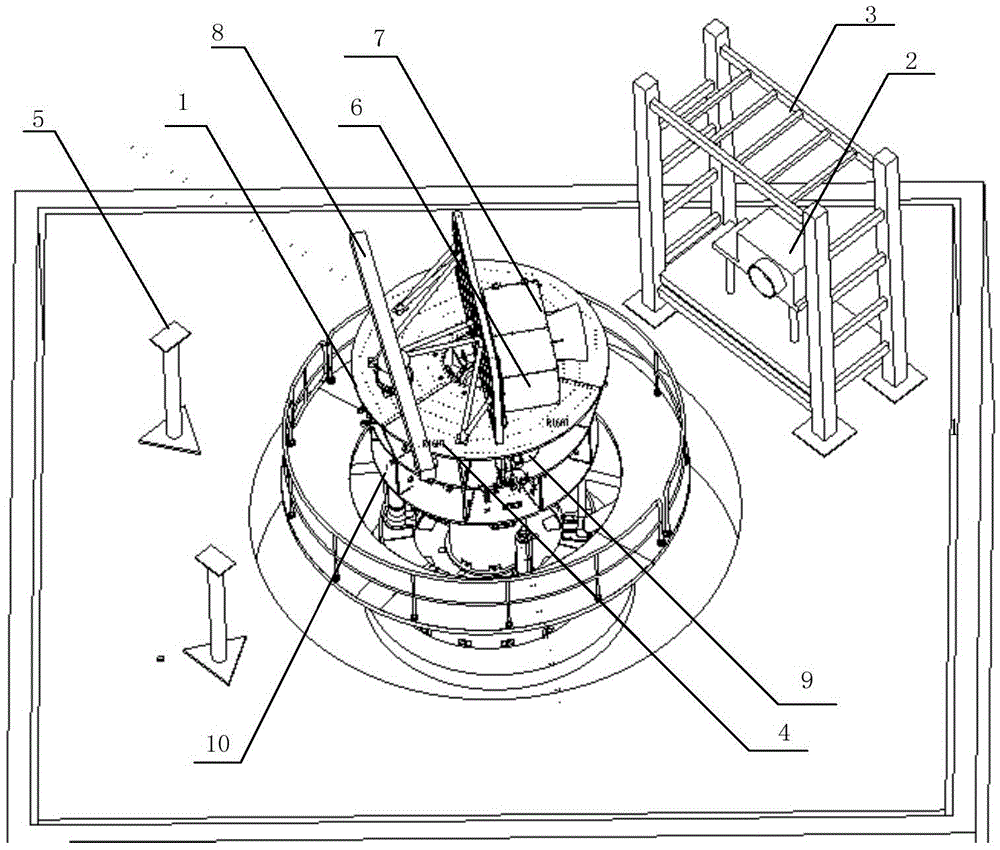
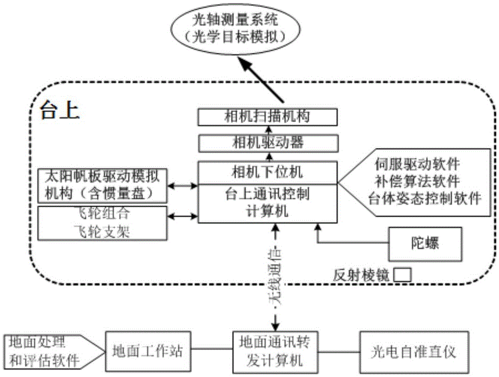
[0043]The invention discloses a full-physics test device and a test method for satellite image navigation and registration. The test device includes a three-axis air-floating platform 1, an optical axis measurement system 2, an adjustment mechanism 3, a wireless communication device 4, and an optoelectronic self-collimation. Instrument 5, camera mounting plate 6, and on-board test equipment such as imaging camera including scanning mechanism 7, solar panel drive simulation mechanism 8, gyro combination 9, flywhe...


PUM


Abstract

The invention provides a satellite image navigation and registering full-physical testing device and testing method. The satellite image navigation and registering full-physical testing device comprises a three-shaft air floating table (1), an optical axis measuring system (2), an adjusting mechanism (3), a wireless communication device (4), a photoelectric autocollimator (5), a camera mounting plate (6) and on-board testing equipment such as an imaging camera (7) (including a scanning mechanism), a solar panel driving simulation mechanism (8), a gyro assembly (9), a flywheel assembly (10) and the like. The working state on orbit of a satellite is simulated, and system-level tests are carried out. According to the invention, image navigation and registering air floating table full-physical test verification and performance testing can be carried out on different loads such as a small area array and two-dimensional scanning imaging camera or a large-aperture long-linear-array big area array imaging camera, and on-board image navigation and registering technical schemes and system indexes are enabled to meet on-board requirements.

Description

technical field [0001] The invention relates to the field of navigation and registration, in particular to a satellite image navigation and registration full physical test device and testing method. Background technique [0002] Image navigation and registration is a key technology to compensate for the influence of factors such as spaceborne camera scanning mirror motion interference, satellite attitude changes, orbital drift, and structural thermal deformation on the geometric application of remote sensing satellite images. The US three-axis stable geostationary orbit meteorological satellite, GOES-8 launched in 1994, began to solve the problem of image navigation and registration. It took 11 years to optimize the design of 5 satellites, and the GOES-13 satellite was launched in 2006, and the image navigation and registration performance was significantly improved. [0003] Image navigation and registration technology involves multiple systems such as satellite overall, a...

Claims


Application Information

Patent Timeline
IPC IPC(8): G01S19/08
CPCG01S19/08
Inventor 宋效正吕旺王田野仲惟超潘高伟李志慧俞洁董瑶海汪浩平
Owner SHANGHAI SATELLITE ENG INST
Why Eureka
Try Eureka