Map matching method based on road connection relationship

A technology of connectivity and map matching, applied in the field of map matching, which can solve the problems of poor matching effect, complex model, and high computational cost of the system.

Active Publication Date: 2016-06-01
GUANGXI XINLANG COMM TECH
View PDF16 Cites 59 Cited by
  • Summary
  • Abstract
  • Description
  • Claims
  • Application Information

AI Technical Summary

Problems solved by technology

[0006] At present, there are many research results on map matching; there are relatively simple matching methods, such as the closest point matching method; there are also complex matching methods, such as fuzzy logic algorithms, methods based on cost functions, methods based on D-S evidence reasoning, and methods based on The method of neural network, etc.; the closest point matching method judges based on the distance between the positioning point and the road. This method is simple

Method used


Image

  • Map matching method based on road connection relationship
  • Map matching method based on road connection relationship
  • Map matching method based on road connection relationship

Examples


Example Embodiment

[0041] The preferred embodiments of the present invention will be further described in detail below in conjunction with the accompanying drawings.
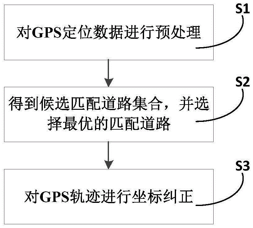
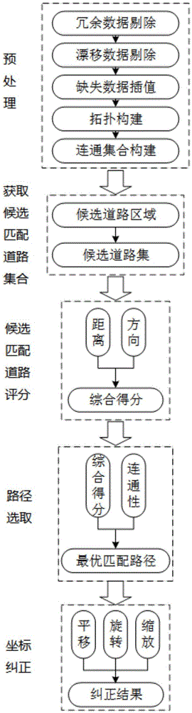
[0042] Such as figure 1 with figure 2 As shown, this example provides a map matching method based on road connectivity, including the following steps:

[0043] Step S1, preprocessing the GPS positioning data;

[0044] Step S2: Establish road matching rules based on the two factors of distance and direction, and then obtain a set of candidate matching roads, calculate the similarity between GPS trajectory and candidate matching roads based on road connectivity, and then select the one with the greatest similarity as the GPS trajectory matching the way;

[0045] Step S3: Perform coordinate correction on the GPS track, which is used to correct the GPS track to the corresponding matching road according to relevant rules.

[0046] In step S1 in this example, the removal or interpolation is performed for data redundancy, data missing, and data...


PUM


Abstract

The invention provides a map matching method based on a road connection relationship. The method comprises the steps that S1, GPS positioning data is preprocessed; S2, road matching rules are established according to the distance factor and the direction factor, then a candidate matching road set is obtained, similarity between a GPS track and candidate matching roads is calculated based on road connection, and then the candidate matching road most similar to the GPS track is selected as the matching road of the GPS track; S3, the GPS track is subjected to coordinate correction. According to the method, corresponding detection and processing methods are proposed based on error data of different error types, and therefore high efficiency and accuracy of the map matching method are ensured; correlation between historical data is considered, and the influence of a certain point with a large error on direction calculation is lowered; constraint of historical matching information is also considered, so that the accuracy rate of the matching result is high; compared with a model in the prior art, the overall technical scheme is simpler, and continuity and the matching effect are better.

Description

technical field [0001] The invention relates to a map matching method, in particular to a map matching method based on road connection relations. Background technique [0002] In recent years, satellite navigation technology, especially the Global Positioning System (GPS), has been widely used in road traffic positioning. The application of GPS in traffic positioning includes route navigation, vehicle scheduling, accident emergency response, positioning tracking and road conditions information acquisition, etc. With the rapid development of these location-based services (Location Based Service, LBS), a large amount of vehicle trajectory data will continue to be generated. It is a current research hotspot to analyze these trajectory data, and then to mine useful information and provide better information services. [0003] However, due to errors in GPS positioning data, GPS positioning results often deviate from the actual geographic location, which causes difficulties for l...

Claims


Application Information

Patent Timeline
IPC IPC(8): G01C21/30
CPCG01C21/30
Inventor 段炼覃庆文
Owner GUANGXI XINLANG COMM TECH
Why Eureka
Try Eureka