Method for extracting estuary intertidal zone classification area by using object-oriented classification technology

An object-oriented, classification technology, applied in image analysis, 2D image generation, data processing input/output process, etc., can solve problems such as differences in land use types and large differences in soil properties in different reclamation areas, and achieve operational Simple, good identification ability, accurate results

Inactive Publication Date: 2016-06-15
ZHEJIANG GONGSHANG UNIVERSITY
View PDF2 Cites 8 Cited by
  • Summary
  • Abstract
  • Description
  • Claims
  • Application Information

AI Technical Summary

Problems solved by technology

Due to the different history of tidal flat reclamation and development and utilization methods, the soil properties are quite different from the old reclamation area to the new reclamation area. Affected by it, there are also great differences in land use, agricultural planting structure and crop types, and Further caused the differences in land use types in different reclamation areas

Method used


Image

  • Method for extracting estuary intertidal zone classification area by using object-oriented classification technology
  • Method for extracting estuary intertidal zone classification area by using object-oriented classification technology
  • Method for extracting estuary intertidal zone classification area by using object-oriented classification technology

Examples


Embodiment Construction

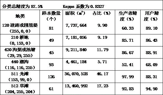
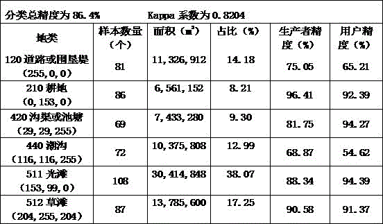
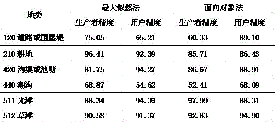
[0020] Now take the area extraction of tidal flat land classification in Hangzhou Bay Wetland as an example to illustrate in detail. The remote sensing image used in this study is the Gaofen No. 1 remote sensing image of the Hangzhou Bay Wetland Research Area on August 9, 2013 (spatial resolution is 8m, blue, green, red, and near-infrared 4 bands).

[0021] A method for object-oriented classification technology to realize the extraction of tidal flat classification area in Hangzhou Bay, comprising the following steps:

[0022] Step 1: Extract water edge

[0023] Using the remote sensing image on August 9, 2013, use the GlobalMapper software to make a mask for the places involving water bodies and tidal flats, and then perform supervised classification of water bodies and tidal flats in ENVI, classify the classification results, and then cluster them, and then export Vector map, the exported vector map was imported into GlobalMapper software for correction, and the water edge ...


PUM


Abstract

The invention discloses a method for extracting an estuary intertidal zone classification area by using an object-oriented classification technology, characterized by comprising the following steps of: (1) extracting water edges of estuary intertidal zones, wherein places involving water and the intertidal zones in a high resolution No.1 satellite remote sensing image are made into a mask by using Global Mapper software; supervised classification is performed on the water and the intertidal zones in ENVI; classification results are classified and clustered; vector graphs are guided out and then guided into the Global Mapper software for correction; and the water edges of the estuary intertidal zones are extracted and obtained; (2) making the vector graphs with an shp format; and (3) extracting the estuary intertidal zone classification area, wherein intertidal zone classification is performed by using a sample-based object-oriented flow of the ENVI software, and the data of the intertidal zone classification area is extracted. The method of the invention can perform high precision extraction on the intertidal zone classification utilization information. The operation is convenient, and the feasibility is strong.

Description

technical field [0001] The invention relates to an object-oriented classification technology to realize a method for extracting classified area of ​​estuary tidal flats. Background technique [0002] Tidal flat reclamation is one of the important measures taken by coastal areas to alleviate the demand for land, stick to the red line of cultivated land, and reconcile the contradiction between man and land. Due to the different history and development and utilization methods of tidal flat reclamation, the soil properties are quite different from the old reclamation area to the new reclamation area. Affected by it, there are also great differences in land use, agricultural planting structure and crop types, and This further caused the differences in land use types in different reclamation areas. [0003] Academia has done a lot of research on the land use structure and its changes in the tidal flat reclamation area, mainly using traditional supervised or unsupervised classific...

Claims


Application Information

Patent Timeline
Patent Type & Authority Applications(China)
IPC IPC(8): G06T7/60G06K9/00G06K9/62
CPCG06F3/04845G06T11/00G06T2207/10032G06T2210/32G06V20/182G06V20/13G06V20/52G06F18/23G06F18/24147G06F18/24
Inventor 程乾陈奕霏孔邦杰
Owner ZHEJIANG GONGSHANG UNIVERSITY
Why Eureka
Try Eureka