Method and system for positioning interactive space

一种空间定位、交互式的技术,应用在定位、无线电波测量系统、仪器等方向,能够解决设备冗杂测量时间等问题,达到结构简单、提高效率、增加稳定性的效果

Pending Publication Date: 2016-08-03
VR TECH (SHENZHEN) LTD
View PDF14 Cites 22 Cited by
  • Summary
  • Abstract
  • Description
  • Claims
  • Application Information

AI Technical Summary

Problems solved by technology

[0004] In order to solve the defects of redundant equipment and long measurement time in the current space positioning system, the present invention provides an interactive space positioning method and system with simple equipment and short measurement time

Method used


Image

  • Method and system for positioning interactive space
  • Method and system for positioning interactive space
  • Method and system for positioning interactive space

Examples


Embodiment Construction

[0038] In order to solve the defects of redundant equipment and long measurement time in the current space positioning system, the present invention provides an interactive space positioning method and system with simple equipment and short measurement time.

[0039] In order to have a clearer understanding of the technical features, purposes and effects of the present invention, the specific implementation manners of the present invention will now be described in detail with reference to the accompanying drawings.

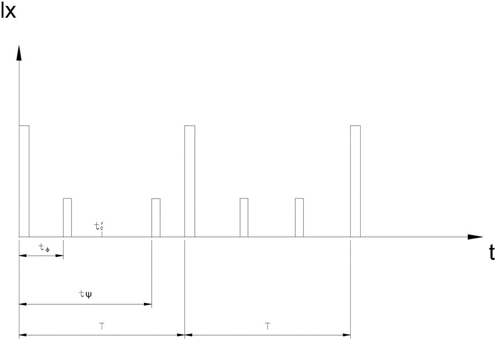
[0040] figure 1It is a schematic diagram of an interactive spatial positioning method and system principle of the present invention. In the coordinate axis, the horizontal axis is the time t, and the vertical axis is the light intensity lx. When the measurement starts, a flash signal is given, and the receiving device receives a light signal that is much larger or much smaller than the measured laser light intensity. The flash signal is mainly used to determine ...


PUM


Abstract

The invention provides a method and a system for positioning an interactive space. The system includes a scanning module, a receiving module and processing module. The receiving module includes an optical signal receiving module array. Compared with prior art, the system uses the method of scanning longitudes and latitudes in an alternative and successive manner, which simplifies computational complexity and at the same time reduces the number of measuring devices and has a simpler structure. The adoption of a rotary polyhedron, a scanning vibrating mirror, and a microcomputer electric reflector enables quality reduction of a rotator, is conducive to reduce centrifugal force generated from the rotation or vibration of the rotator, and increases device stability. The usage of a 2D controllable microcomputer electric reflector further reduces the number of the rotors to one, which further simplifies devices. The periodic flash of a flash lamp can enable the system to better determine a scanning period and prevent data chaos among different periods. An emit light ray processing module can increase or decrease emitting angles of a laser, which enlarges a scanning range.

Description

technical field [0001] The present invention relates to the field of spatial positioning, and more specifically, to an interactive spatial positioning method and system. Background technique [0002] Spatial positioning generally adopts optical or ultrasonic mode for positioning and calculation, and the spatial position of the object to be measured is derived by establishing a model. The general optical spatial positioning system uses laser scanning and light sensor reception to determine the spatial position of the object. This type of spatial positioning system often has the problems of relatively large measuring equipment, long measurement time and inability to measure in real time, and its application range is greatly restricted. limitations. [0003] Chinese patent CN200810150383.5 discloses a space positioning method based on a network of double-rotating laser planar transmitters. Three or more turntable transmitters are rotated by AC servo motors, and two linear lase...

Claims


Application Information

Patent Timeline
Patent Type & Authority Applications(China)
IPC IPC(8): G01S5/02G02B26/10
CPCG01S5/02G02B26/105G01S5/163G01C15/002G01S5/16G01B11/002G01B11/026G01B11/14
Inventor 党少军
Owner VR TECH (SHENZHEN) LTD
Why Eureka
Try Eureka