

Unmanned plane terrain following system and method based on laser radar
A technology of laser radar and unmanned aerial vehicles, which is applied in control/regulation systems, non-electric variable control, instruments, etc., can solve the problems of being easily affected by ambient temperature and air flow, unstable GPS altimeter signals, and small measurement range of ultrasonic altimeters, etc. problems, to achieve the effect of small size, uniform spraying and strong reliability
- Summary
- Abstract
- Description
- Claims
- Application Information
AI Technical Summary
Problems solved by technology
Method used
Image

Examples
Embodiment Construction
[0028] The following will be described in detail in conjunction with the embodiments of the present invention with reference to the accompanying drawings.
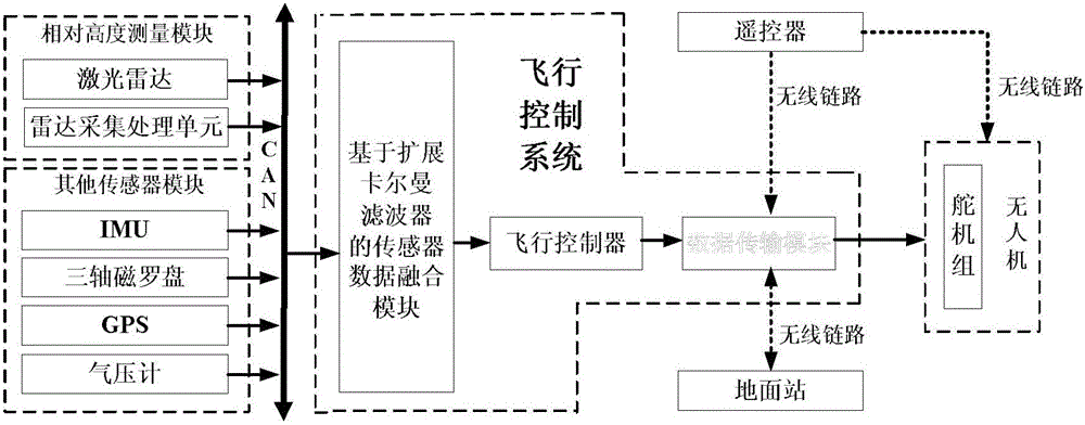
[0029] LiDAR-based UAV terrain following system, including relative altitude measurement module, other sensor modules, and flight control system;
[0030] The relative altitude measurement module includes a laser radar and a radar acquisition and processing unit, the laser radar acquires relative altitude information of the flight environment, and the radar acquisition and processing unit includes an ARM main chip, which is responsible for completing the acquisition and preprocessing of radar data Calculate and transmit the processed results to the flight control system;
[0031] The other sensor modules, including IMU, three-axis magnetic compass, GPS and barometer, are used to obtain the flight status information of the drone;
[0032] The flight control system includes a sensor data fusion module based on an extended K...
PUM
 Abstract
Description
Claims
Application Information