Unmanned aerial vehicle accurate position landing method based on image processing and fuzzy control

A technology of fuzzy control and image processing, which is applied in the fields of image recognition and navigation communication, can solve problems such as landing errors and insufficient GPS accuracy, and achieve the effects of simple design, improved intelligence, and easy application

Active Publication Date: 2016-08-17
CHINA JILIANG UNIV
View PDF4 Cites 21 Cited by
  • Summary
  • Abstract
  • Description
  • Claims
  • Application Information

AI Technical Summary

Problems solved by technology

[0003] The object of the present invention is to provide a method for landing an unmanned aerial vehicle at an accurate position based on image processing and fuzzy control, which can use the circular landing point navigation mark as the guidance fixed-point landing information to guide the small quadrotor UAV to perform fixed-point landing, thereby Solve the defect in the prior art that the lack of GPS accuracy leads to landing errors

Method used


Image

  • Unmanned aerial vehicle accurate position landing method based on image processing and fuzzy control
  • Unmanned aerial vehicle accurate position landing method based on image processing and fuzzy control
  • Unmanned aerial vehicle accurate position landing method based on image processing and fuzzy control

Examples


Embodiment Construction

[0034] The specific working process of the present invention will be further described in detail below in conjunction with the accompanying drawings.

[0035] Embodiments of the present invention are as follows:

[0036] The playground of a certain school is selected as the implementation object of this embodiment, and the playground is 150 meters long and 80 meters wide. The landing beacon is placed in the center of the playground, the ground control station is set 10 meters away from the landing beacon, and the drone is about 50 meters above the ground.

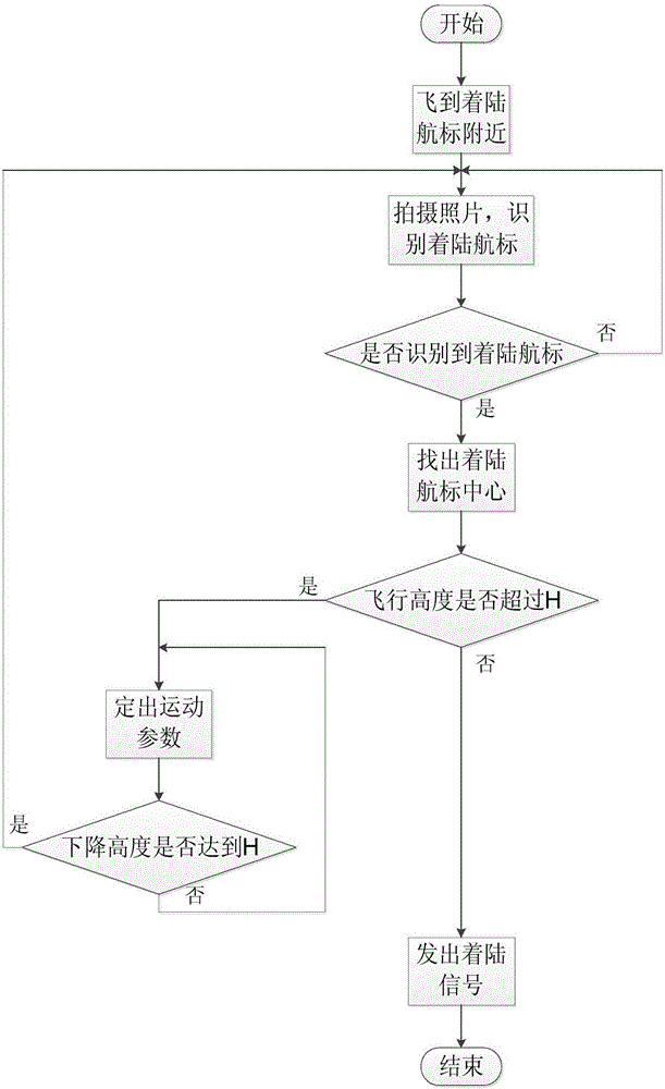
[0037] Step 1. Use the GPS satellite navigation system to make the drone near the landing beacon, that is, let the drone be within the coverage of the wireless local area network of the ground control station. At this time, the ground control station sends a signal, and the camera and barometric altimeter start to work.

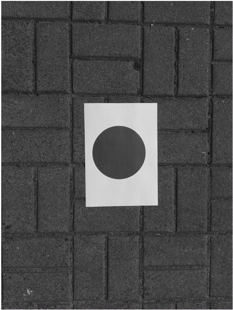
[0038] Such as figure 2 As shown, the landing beacon adopted in this embodiment is a blue circular ...


PUM


Abstract

The invention discloses an unmanned aerial vehicle accurate position landing method based on image processing and fuzzy control. The method comprises the steps of making an unmanned aerial vehicle fly to the position next to a landing navigation mark by means of a GPS satellite navigation system; photographing ground in a vertically downward manner by means of a camera, and identifying a fact that the landing navigation mark is a circular area; finding out the circle center of the circular area according to an image processing method and using the circle center as the landing position; correcting a yaw angle through real-time movement of the unmanned aerial vehicle, and obtaining parameters for controlling motion of the unmanned aerial vehicle according to two included angles of the circle center on a spatial coordinate by means of a fuzzy control method; monitoring the ground clearance of the unmanned aerial vehicle in real time by means of an air pressure height measurer and an ultrasonic radar; and transmitting by a ground control station for realizing slow landing. The unmanned aerial vehicle accurate position landing method has advantages of overcoming a defect of landing error caused by insufficient GPS satellite positioning precision, greatly reducing cost in utilizing an accurate sensor, realizing no requirement for establishment of an accurate mathematical model, and obtaining simple design and convenient application.

Description

technical field [0001] The invention belongs to the technical field of image recognition and navigation communication, and in particular relates to an automatic control method for precise landing of a small quadrotor drone. Background technique [0002] In recent years, due to the advantages of convenient use, low operating cost, high flight accuracy, and flexible maneuvering, UAVs have a large demand in practical applications, such as reconnaissance and shooting, fire rescue, scientific data mobile phones, and agricultural pest control. However, the fixed-point landing of drones has always been a problem, and it is difficult to achieve the purpose of precise landing. Contents of the invention [0003] The object of the present invention is to provide a method for landing an unmanned aerial vehicle at a precise position based on image processing and fuzzy control, which can use the circular landing point navigation mark as the guiding fixed-point landing information to gui...

Claims


Application Information

Patent Timeline
Patent Type & Authority Applications(China)
IPC IPC(8): G05D1/08
CPCG05D1/08
Inventor 郑恩辉巫岳董恩来谢敏陈乐
Owner CHINA JILIANG UNIV
Why Eureka
Try Eureka