Fluvial cross section surveying and mapping system

A technology of river channel section and surveying instrument, which is applied in section drawing, surveying and navigation, and measuring devices, etc. It can solve the problems of discontinuous data, low efficiency and high error of underwater terrain measurement, and achieve automatic measurement and reduce manpower. The workload and data processing are cumbersome, and the effect of improving accuracy

Inactive Publication Date: 2016-08-31
山东一能新能源科技有限公司
View PDF4 Cites 11 Cited by
  • Summary
  • Abstract
  • Description
  • Claims
  • Application Information

AI Technical Summary

Problems solved by technology

At present, a large number of single-beam echoes are used in my country. Single-beam echoes can only emit one beam of sound waves at a time, and only one water depth data point can be obtained.
In addition, if a single-beam echo is used to measure the underwater topography of an area, the distance between the survey point and the survey line must be determined in advance according to the drawing scale and specification requirements, and then the survey ship is used to measure point by point to draw the topography, etc. High-line map or cross-sectional map, the efficiency of underwater topographic measurement is not high, so manual point vertical measurement has the defects of data discontinuity, high error, and high-intensity measurement

Method used


Image

  • Fluvial cross section surveying and mapping system
  • Fluvial cross section surveying and mapping system

Examples


Embodiment Construction

[0025] In order to clearly understand the technical solution of the present invention, its detailed structure will be presented in the following description. Obviously, the implementation of the embodiments of the invention is not limited to specific details familiar to those skilled in the art. The preferred embodiments of the present invention are described in detail below, and there may be other implementations besides those described in detail.

[0026] The present invention will be described in further detail below in conjunction with the accompanying drawings and embodiments.

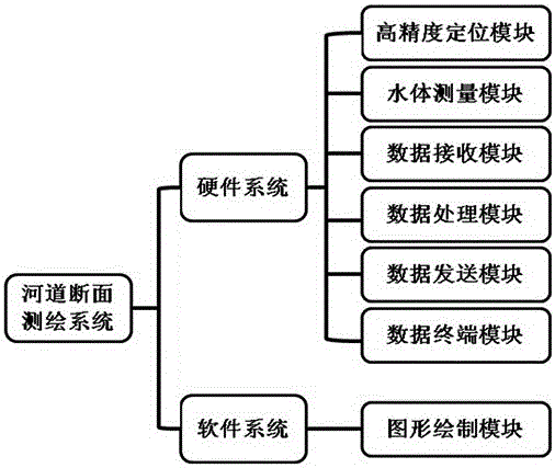
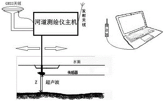
[0027] combine figure 1 and figure 2 , the present embodiment discloses that the channel section surveying and mapping system is composed of a hardware system and a software system. It is generally divided into seven modules. The hardware system includes a high-precision positioning module, a water body measurement module, a data receiving module, a data processing module, a data sending modul...


PUM


Abstract

The invention discloses a fluvial cross section surveying and mapping system which comprises a hardware system and a software system. The hardware system comprises a high-precision positioning module, a water measuring module, a data receiving module, a data processing module, a data transmitting module and a data terminal module. The software system comprises a graph drawing module. Highly-integrated automatic measurement is achieved. High-efficiency, all-weather and high-precision measurement of the underwater cross section is achieved, the work requirements of water conservancy hydrological workers for overwater engineering and water area measurement can be sufficiently met, and manual operation workloads and data processing tediousness are reduced.

Description

technical field [0001] The invention belongs to the field of instrument measurement, in particular to a channel section surveying and mapping system. Background technique [0002] At present, the rope plumb method has been used to detect the underwater topography. During the navigation of the survey ship, at regular intervals, the surveyor uses a rope tied with a plumb weight to measure a water depth point. The underwater section measured by this method will appear discontinuous, and it is difficult to find navigation obstacles in the water. And the original emitted ultrasonic beam is about 28°-0°, that is, the water depth recorded by each echo signal on the recording paper is the shallowest value within the range covered by each beam on the seabed, and the accuracy is not high. [0003] The basic principle of underwater topographic survey is to use the reflection time of sound waves to calculate the water depth of the point. At present, a large number of single-beam echoe...

Claims


Application Information

Patent Timeline
Patent Type & Authority Applications(China)
IPC IPC(8): G01C7/02G01C13/00
CPCG01C7/02G01C13/008Y02A90/30
Inventor 黄文靖孙志平王宁黄兴隆张宁波王冬松丁玉婷赵勇进
Owner 山东一能新能源科技有限公司
Why Eureka
Try Eureka