Pure remote sensing data driven drainage basin water circulation simulation method

A technology of remote sensing data and simulation methods, applied in the field of navigation remote sensing, to achieve the effect of enhancing the physical mechanism, reducing dependence, and expanding the scope of application

Active Publication Date: 2016-08-31
SATELLITE ENVIRONMENT CENT MINIST OF ENVIRONMENTAL PROTECTION
View PDF3 Cites 21 Cited by
  • Summary
  • Abstract
  • Description
  • Claims
  • Application Information

AI Technical Summary

Problems solved by technology

[0003] Remote sensing and spatial information technology are also increasingly used in the acquisition of parameters in hydrological simulations, but few people have realized hydrological model simulations with strong physical mechanisms based entirely on remote sensing and spatial data

Method used


Image

  • Pure remote sensing data driven drainage basin water circulation simulation method
  • Pure remote sensing data driven drainage basin water circulation simulation method
  • Pure remote sensing data driven drainage basin water circulation simulation method

Examples


Embodiment Construction

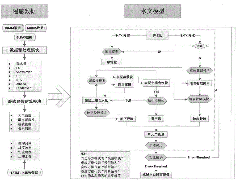
[0060] The technical solutions of the present invention will be clearly and completely described below in conjunction with the accompanying drawings and specific embodiments.

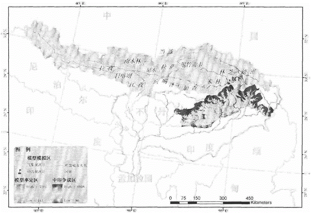
[0061] Study area and data
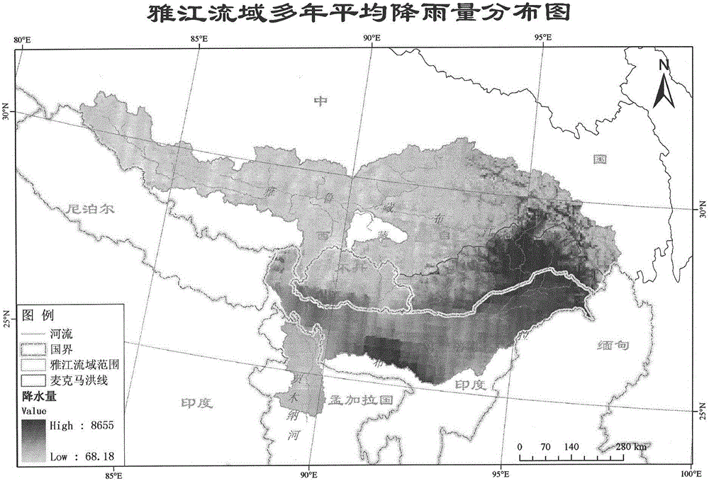
[0062] The research area of ​​the embodiment of the present invention is the Yarlung Zangbo River Basin, an international river in Southwest my country. In the research area of ​​the example, the daily runoff observation data from Nuxia Station in the Yajiang River Basin from 2006 to 2009 were selected and used to verify the final result of the model simulation on the daily runoff process curve. . In the embodiment, the actual measured daily average temperature of 8 meteorological stations in the Yajiang River Basin in 2005-2012 was used to verify the accuracy of the GLDAS downscaled air temperature data; The accuracy of the precipitation data retrieved by remote sensing was verified. In addition, some observation data from the lower reaches of the Yalu Zangbo River and t...


PUM


Abstract

The invention discloses a pure remote sensing data driven drainage basin water circulation simulation method, comprising the following steps: building a drainage basin water circulation simulation framework including a vegetation interception and evapotranspiration process, a runoff production process and a runoff concentration process and compatible with spatial information; completing the simulation of drainage basin runoff production and concentration processes entirely based on remote sensing data, and getting the background values of total runoff yield and runoff volume of any grid point in a drainage basin; and adding a model parameter self-optimization module, constructing an objective function, carrying out random sampling to generate a simulation parameter sample combination to be calibrated, introducing a model for iterative operation, and determining eligible drainage basin water circulation simulation parameters and runoff production and concentration simulation results. The dependence on the observation data of a traditional meteorological site is reduced effectively, the spatio-temporal continuity and spatial heterogeneity of water circulation are better reflected, and the physical mechanism and multi-source data compatibility of the method are enhanced.

Description

technical field [0001] The invention relates to the technical field of navigation remote sensing, in particular to a method for simulating water circulation in a basin driven by pure remote sensing data. Background technique [0002] The mastery of water cycle laws and internal mechanisms directly affects the rationality and scientificity of water resources management in river basins. However, for a long time, hydrological research has mostly focused on river basins with relatively abundant observation data, and little research has been done on areas lacking observation data. How to carry out the simulation of watershed hydrological process without relying on the observation data of traditional stations, and then develop the theory and method of watershed hydrological analysis that can meet the changing environment, has become one of the difficulties and hot issues in the recent international research on water resources and water environment. Distributed hydrological model i...

Claims


Application Information

Patent Timeline
Patent Type & Authority Applications(China)
IPC IPC(8): G06F19/00
CPCG06F2219/10G16Z99/00
Inventor 蔡明勇王桥杨胜天曾红娟申文明侯鹏
Owner SATELLITE ENVIRONMENT CENT MINIST OF ENVIRONMENTAL PROTECTION
Why Eureka
Try Eureka