Real-time tracking system for flight test of sphere body near space aerocraft

A near space and flight test technology, applied in the field of near space aircraft flight test, can solve problems such as aircraft tracking failure and aircraft disconnection, and achieve the effect of ensuring positioning and tracking and improving positioning accuracy

Inactive Publication Date: 2016-09-21
NO 63655 TROOPS OF THE CHINESE PEOPLES LIBERATION ARMY
View PDF5 Cites 3 Cited by
  • Summary
  • Abstract
  • Description
  • Claims
  • Application Information

AI Technical Summary

Problems solved by technology

[0005] like figure 1 As shown, in the prior art, there is a near-space vehicle belonging to the category of floating air balloons, which is called a single-sphere near-space vehicle. This single-sphere near-space vehicle includes a closed balloon 1, the outer shell of which is coated with a A layer of metal coating 1-1, the below of the closed balloon 1 is suspended with a pod 2 by a stay rope 6, and a helium container 5 is arranged in the pod 2, and is used for disabling the helium container 5 Helium rushes into the closed balloon 1 or pumps the helium in the closed balloon 1 into the air pump 3 of the helium container 5, and an air pump controller for controlling the inflation and pumping of the air pump 3 4. However, during the flight test of this single-sphere near-space aircraft, radar is used to track the aircraft, but due to the complex environment changes in the adjacent space, and the metal coating 1-1 on the outer surface of the closed balloon 1 has a negative effect on radio signals. The shielding effect of the aircraft often results in the failure of tracking the aircraft and the loss of contact with the aircraft

Method used


Image

  • Real-time tracking system for flight test of sphere body near space aerocraft
  • Real-time tracking system for flight test of sphere body near space aerocraft
  • Real-time tracking system for flight test of sphere body near space aerocraft

Examples


Embodiment Construction

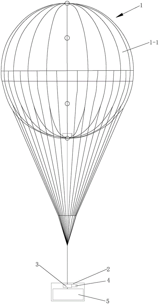
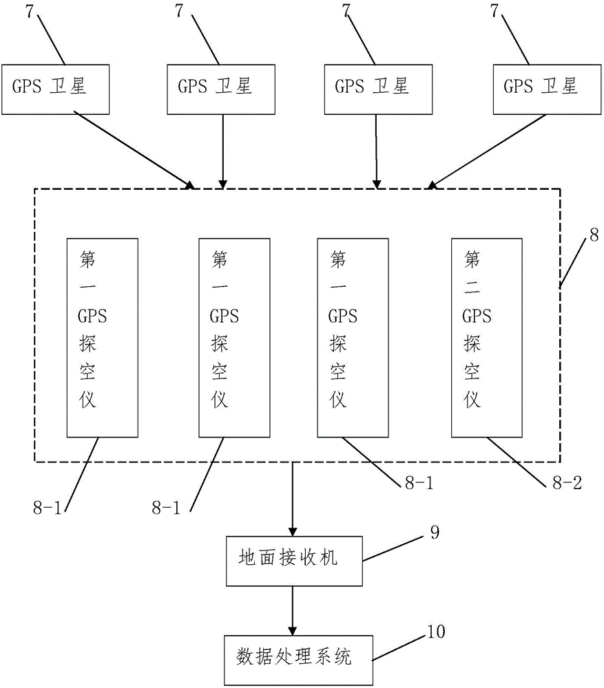
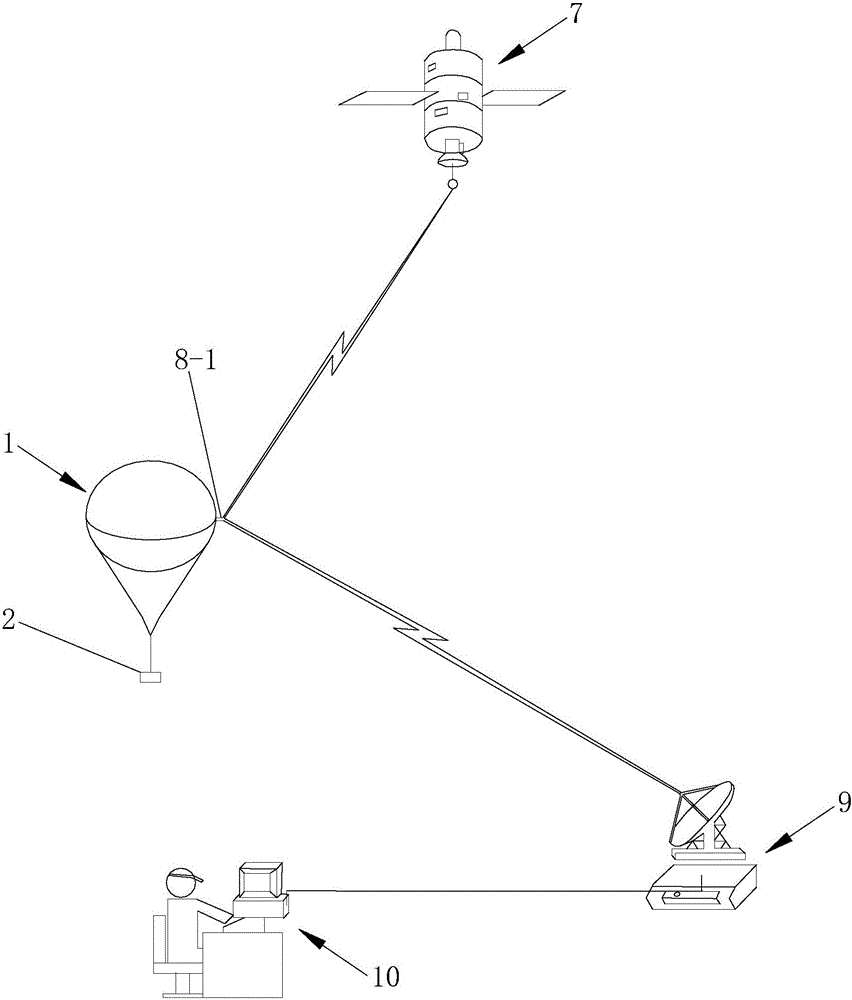
[0035] Such as figure 2 with image 3 A real-time tracking system for the flight test of a single-sphere near-space vehicle is shown, including:

[0036] At least four GPS satellites 7, each GPS satellite 7 sends out its satellite space coordinate information;

[0037] GPS sounding device 8, is used for receiving described satellite spatial coordinate information and collecting environmental meteorological parameter, and sends described satellite spatial coordinate information and described environmental meteorological parameter;

[0038] A ground receiver 9, configured to receive the satellite spatial coordinate information and the environmental meteorological parameters sent by the GPS sounding device 8, and output the satellite spatial coordinate information and the environmental meteorological parameters;

[0039] The data processing system 10 is used to receive the satellite spatial coordinate information and the environmental meteorological parameters output by the gr...


PUM


Abstract

The present invention discloses a real-time tracking system for flight test of a sphere body near space aerocraft. The system comprises: at least four GPS satellites; a GPS sounding device configured to receive the satellite space coordinate information and collect the environment meteorology parameter; a ground receiver configured to receive the satellite space coordinate information and environment meteorology parameters sent by the GPS sounding device; and a data processing system configured to receive the satellite space coordinate information and environment meteorology parameters outputted by the ground receiver and calculate the space coordinate information of a GPS sonde according to the satellite space coordinate information to realize location of the sphere body near space aerocraft. The GPS sounding device includes a plurality of first GPS sondes which are distributed at intervals along with the circumference direction of the closed ball capsule of the sphere body near space aerocraft on the horizontal direction, and at least one first GPS snode communicates with the ground receiver. The real-time tracking system for flight test of the sphere body near space aerocraft is able to realize real-time tracking of the near space aerocraft and effectively ensure there is no loss of communication with the near space aerocraft.

Description

technical field [0001] The invention belongs to the technical field of near-space vehicle flight tests, and in particular relates to a real-time tracking system for single-sphere near-space vehicle flight tests. Background technique [0002] Adjacent space usually refers to the airspace at 20-100 kilometers from the surface. The near-space region includes most of the stratosphere (height 11-50 kilometers), the middle atmospheric region (height 50-80 kilometers) and some Ionosphere region (altitude 60-100 km). The salient features of the adjacent space include: relatively thin air; low ambient pressure; complex changes in ambient temperature; strong ozone and solar radiation; and the smallest average wind speed in the 20-40 km area. [0003] The airspace below the adjacent space (below 20 kilometers) is the main activity space of traditional aircraft, and the airspace above it (above 100 kilometers) is the operating space of spacecraft. As the name implies, a near-space veh...

Claims


Application Information

Patent Timeline
Patent Type & Authority Applications(China)
IPC IPC(8): G01S19/01G01S19/42
CPCG01S19/01G01S19/42
Inventor 关军唐敬任莉王建华秦洪才韩燕郑伟静文元宏王朴军赵久权石鹏飞
Owner NO 63655 TROOPS OF THE CHINESE PEOPLES LIBERATION ARMY
Why Eureka
Try Eureka