Method for quickly discovering changed land by adopting unmanned aerial vehicle remote sensing images

A discovery method and UAV technology, applied in the field of image processing, can solve the problems of impossibility, high cost of satellite image acquisition and processing, and large manpower and material resources, so as to improve accuracy and reduce the risk of misjudgment of single information. Effect

Active Publication Date: 2016-09-21
SOUTHEAST UNIV
View PDF3 Cites 23 Cited by
  • Summary
  • Abstract
  • Description
  • Claims
  • Application Information

AI Technical Summary

Problems solved by technology

[0003] The current land monitoring methods in our country can be simply expressed as "watching from the sky, checking from the ground, and managing online". "Seeing from the sky" refers to satellite remote sensing. Satellite imagery in the detection area, and in cloudy areas and poor weather conditions, it is often impossible to obtain clear satellite images, and the cost of obtaining and processing satellite images is relatively high, so the effect of remote sensing monitoring is relatively poor; "Inspection" mainly refers to land inspection vehicles and manual inspection. Compared with remote sensing monitoring, its mobility and flexibility are improved, but its application range is affected by the construction of basic roads. For places without roads, such as mountains, hills and other areas , often cannot complete the monitoring. For places with roads, the current road surface conditions and usage conditions of the roads must also be considered. The monitoring effect is subject to many restrictions, and real-time performance is difficult to be guaranteed; Manpower and material resources, and the accuracy of the news needs to be investigated. From reporting to on-site inspection, confirmation, and then to data update, the cycle is often long, the real-time performance is poor, and there is little effect in land monitoring
[0004] The current UAV remote sensing image stitching detection technology generally requires three steps of air flight, ground control and indoor mapping before it can be applied to land and resources management. Ground control requires a large number of professionals to use professional measuring instruments to measure on-site. In areas with inconspicuous ground features such as mountains, rivers, and forests, personnel cannot reach or accurately locate, and it is often difficult or impossible to obtain ground control points, which is time-consuming and labor-intensive with little effect

Method used


Image

  • Method for quickly discovering changed land by adopting unmanned aerial vehicle remote sensing images
  • Method for quickly discovering changed land by adopting unmanned aerial vehicle remote sensing images

Examples


Embodiment Construction

[0026] The present invention will be further described below in conjunction with the accompanying drawings.

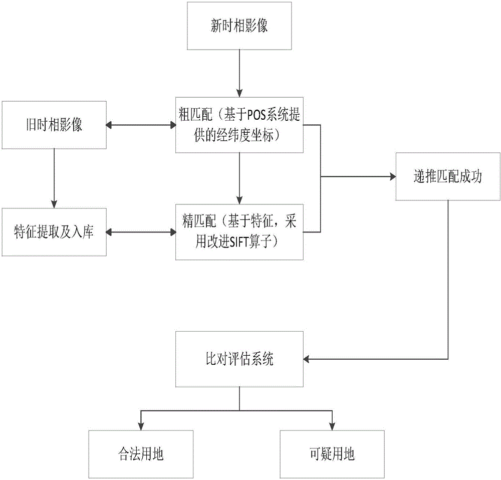
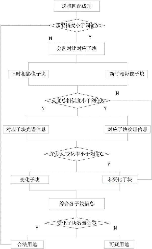
[0027] Such as figure 1 As shown, a method for rapid discovery of changing land use using UAV remote sensing images includes the following steps:

[0028] Step 1: Use the SURF method to retrieve the feature points of the old phase orthophoto, and store the retrieved feature points in a matching library. Among them, the old phase orthophotos are related old phase images such as survey area maps, satellite images, and UAV images archived in the Bureau of Land and Resources. Use the SURF method to detect feature points and express them as 128-dimensional vectors. Each feature point has its own geographic coordinate information, which is stored in a K-D tree that is easy to search, and the retrieved feature points are in a pattern that is easy to match. It is stored in a matching library, so as to complete the retrieval and organization of large-scale old phase image fea...


PUM


Abstract

The invention provides a method for quickly discovering changed land by adopting unmanned aerial vehicle remote sensing images. The method comprises the steps of firstly performing primary characteristic point retrieval on old orthoimages; secondly performing aerial photography by utilizing an unmanned aerial vehicle to obtain unmanned aerial vehicle images of a landform, and obtaining search comparison domains; thirdly preliminarily determining whether the landform is changed or not through characteristic point matching; and fourthly performing comparative analysis through a spectrum and texture dual-mode comprehensive comparative detection method to accurately determine whether suspicious land appears or not. Compared with a conventional technology, the method has the advantages that a suspicious ground object can be quickly and automatically discovered without arranging a large amount of ground control points and splicing the unmanned aerial vehicle images, so that the precision is high, and the time and labor are saved.

Description

technical field [0001] The invention relates to the field of image processing, in particular to a technology for quickly discovering changing land use using drone images in land surveys. Background technique [0002] Since ancient times, land has been a precious natural resource for human survival and development, and the sustainable use of land is the cornerstone of the sustainable development of human society. my country is at a critical moment of urbanization and social transformation, the land is under enormous pressure, the relationship between man and land is becoming increasingly tense, and there are many outstanding problems in the use of newly-added construction land in villages and towns. the sustainable development of our country's economy. For this reason, the party and the state attach great importance to it, and have adopted a series of measures to strengthen land management and stop the phenomenon of illegal occupation of cultivated land and abuse of land. Ar...

Claims


Application Information

Patent Timeline
Patent Type & Authority Applications(China)
IPC IPC(8): G06F17/30
CPCG06F16/29G06F16/583
Inventor 张小国黄鸿飞吕家东王庆
Owner SOUTHEAST UNIV
Why Eureka
Try Eureka