
Handheld high-precision GNSS positioning acquisition unit and acquisition method thereof

A collector and high-precision technology, applied in satellite radio beacon positioning systems, instruments, measuring devices, etc., can solve the problems of affecting operation efficiency, increasing difficulty of use, and slow speed, so as to save copying, improve operation efficiency, The effect of saving time and cost

Inactive Publication Date: 2016-09-28
SOUTH CHINA AGRI UNIV
View PDF6 Cites 6 Cited by
  • Summary
  • Abstract
  • Description
  • Claims
  • Application Information

AI Technical Summary

Problems solved by technology

Due to the slow speed of agricultural machinery, it seriously affects the operation efficiency and increases the difficulty of use in the application of large-area fields, large-resistance fields or multiple fields.

Method used


Image

  • Handheld high-precision GNSS positioning acquisition unit and acquisition method thereof
  • Handheld high-precision GNSS positioning acquisition unit and acquisition method thereof
  • Handheld high-precision GNSS positioning acquisition unit and acquisition method thereof

Examples


Embodiment 1

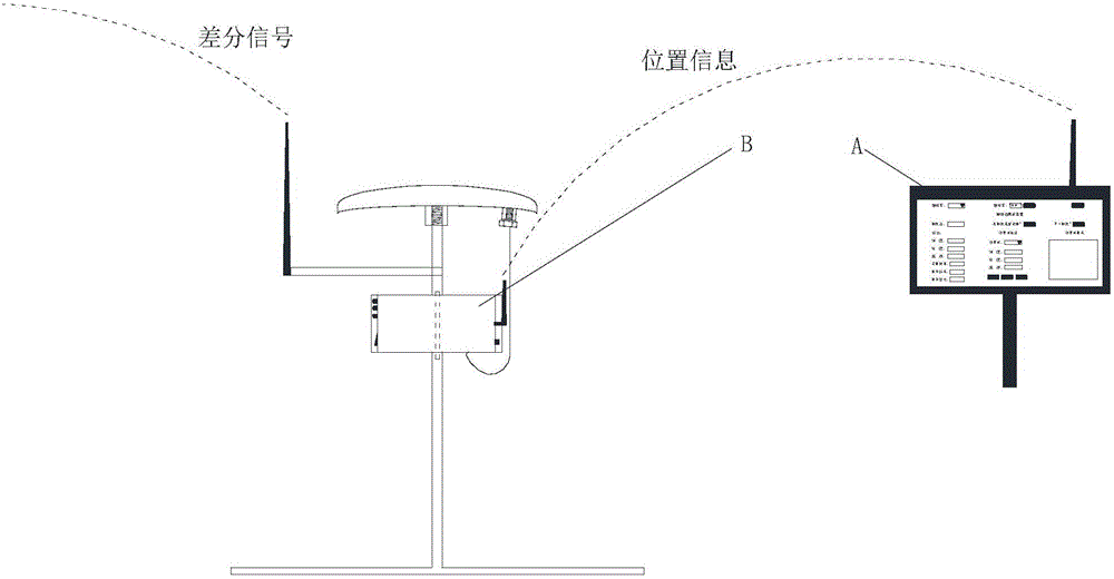
[0039] figure 1 It is a schematic diagram of the overall structure of a hand-held high-precision GNSS positioning collector in this embodiment, and the collector includes an upper computer A and a lower computer B. The upper computer is used to receive, display, and save the location information of the boundary points of the plot; the lower computer is used to receive satellite and differential signals, obtain high-precision positioning information at the boundary points, and send the positioning information to the upper computer through wireless.

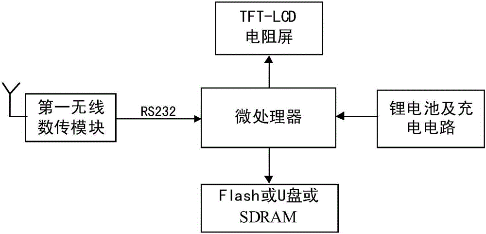
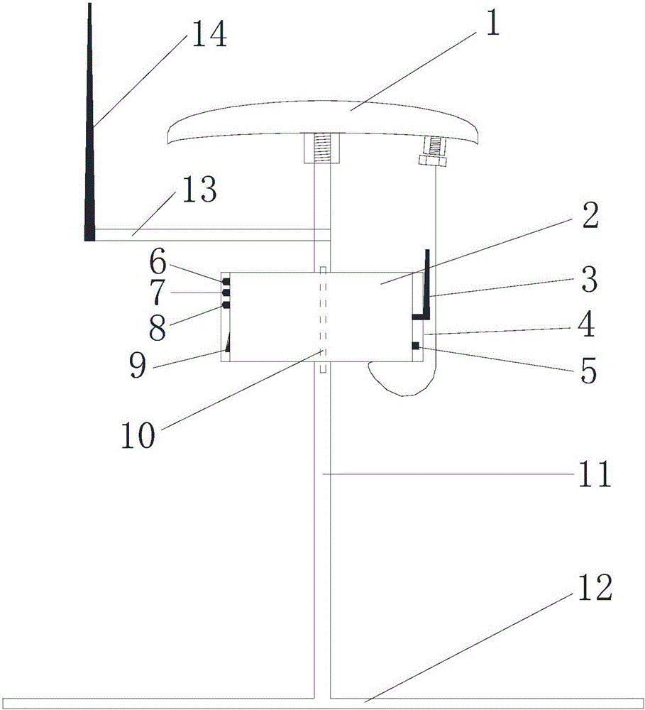
[0040] Combine below figure 2 , 3 4. Explain the specific structure of the upper computer and the lower computer.

[0041] In this embodiment, the hardware platform of the upper computer is based on the S3C2416X microprocessor, equipped with a 4000mAh lithium battery, an industrial-grade 7-inch TFT-LCD resistive screen, the first wireless data transmission module, 2G FLASH and 128M SDRAM, and works continuously The time is more...


PUM


Abstract

The invention discloses a hand-held high-precision GNSS positioning collector and a collection method. The collector includes an upper computer and a lower computer. The hardware platform of the upper computer takes the microprocessor as the core, and is equipped with a lithium battery, a resistive screen, a memory chip and a wireless data transmission module. The upper computer is based on the WinCE embedded operating system, which displays the location information and positioning quality information of the current sampling point in real time, and can lock and save the current location data through the touch screen buttons; the lower computer includes the sampling point support frame, GNSS antenna, and data transmission radio station Antenna and electric control box, the lower computer receives satellite and differential signals, obtains high-precision positioning information at the sampling point, and sends it to the upper computer through the wireless data transmission module. The invention can sample the boundary points of farmland plots off-line, and provide original GNSS positioning data with centimeter-level precision for system navigation operation route planning. It has the advantages of small size, matching with the handheld monitoring terminal, and high efficiency of point collection.

Description

technical field [0001] The invention relates to the field of GNSS (Global Navigation Satellite System, Global Navigation Satellite System) positioning and navigation of agricultural machinery, in particular to a hand-held high-precision GNSS positioning collector and a collection method. Background technique [0002] The automatic navigation technology of agricultural machinery is one of the important supporting technologies of modern agricultural machinery and equipment. Realizing the intelligent navigation of agricultural machinery can effectively reduce the labor intensity of drivers and improve the quality of farmland operations, which has important theoretical research significance and practical application value. [0003] In the actual application of automatic navigation operation of agricultural machinery, in order to carry out intelligent navigation, it is first necessary to collect the precise position of the boundary point of the operation plot. In order to collec...

Claims


Application Information

Patent Timeline
IPC IPC(8): G01S19/14G01S19/42
CPCG01S19/14G01S19/42
Inventor 张智刚王辉张亚娇罗锡文周志艳刘兆鹏黄培奎
Owner SOUTH CHINA AGRI UNIV
Learn More