A stitching method of aerial images and geographic data based on orb feature matching

A technology for aerial photography and geographic data, which is used in image data processing, image enhancement, image analysis, etc.

Active Publication Date: 2019-02-22
THE 28TH RES INST OF CHINA ELECTRONICS TECH GROUP CORP
View PDF6 Cites 0 Cited by
  • Summary
  • Abstract
  • Description
  • Claims
  • Application Information

AI Technical Summary

Problems solved by technology

[0006] In recent years, a large number of stitching algorithms based on SIFT / SURF / ORB / Harris detection have been proposed, but many of them only process the image itself

Method used


Image

  • A stitching method of aerial images and geographic data based on orb feature matching
  • A stitching method of aerial images and geographic data based on orb feature matching
  • A stitching method of aerial images and geographic data based on orb feature matching

Examples


Embodiment

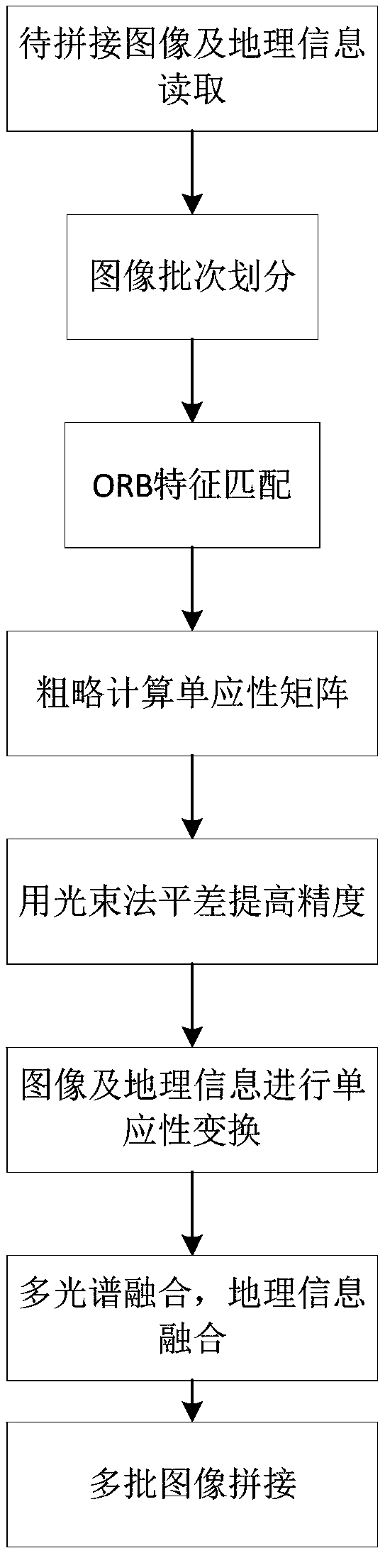
[0105] This embodiment includes the following processing steps:

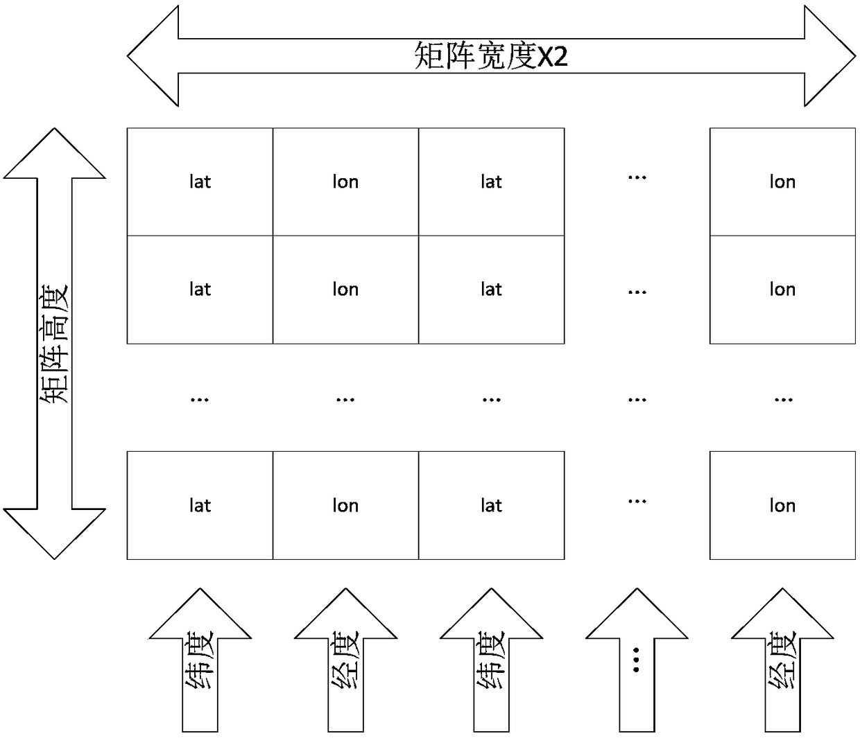
[0106] 1. Read the geographical information and the image into the memory together to obtain the image to be stitched and the matrix storing the latitude and longitude information, and store the geographical information in a 2-dimensional double-precision floating-point matrix. In order to facilitate image processing and use image processing functions, the geographic information matrix is ​​stored in XML structure and stored as a geographic information file with the same name as the image in .xml.gz format. The storage structure of the dual-channel geographic information matrix is ​​as follows: figure 1 As shown, the .xml.gz file is the compressed format of the .xml file, and its xml file structure is as follows:

[0107]

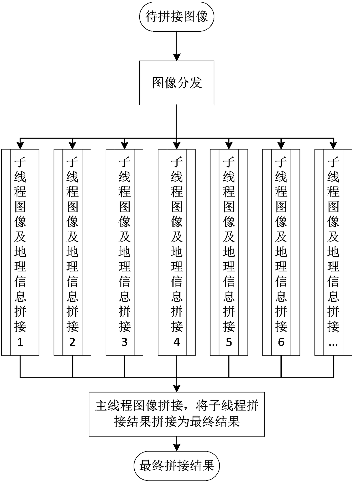
[0108]2. In order to improve the calculation speed of the algorithm, all processor cores can be used for splicing, and the system automatically divides the spliced ​​images into batches, ...


PUM


Abstract

The present invention proposes a method for splicing aerial images and geographic data based on ORB feature matching, comprising: step 1, reading images to be spliced ​​and geographic information; step 2, assigning tasks to processors; step 3, extracting images to be spliced ORB features; Step 4, initialize and estimate the camera parameters of the image to be stitched and obtain the rotation matrix; Step 5, use bundle adjustment to improve the estimation accuracy; Step 6, perform initial stitching on the image to be stitched; Step 7, the Incremental compensation of brightness and multi-band fusion based on the image pyramid are performed on the spliced ​​image, and conditional interpolation and fusion are performed on the spliced ​​geographic information to obtain the spliced ​​result image; step 8, splicing of all threads processed by each processor The resulting images are combined for a comprehensive splicing and fusion, and merged to form the final result image.

Description

technical field [0001] The invention belongs to image and geographic information fusion processing technology, which utilizes the fusion of image splicing technology and geographic data, and particularly relates to an ORB (Oriented FAST and Rotated BRIEF, oriented accelerated segmentation test feature and rotated binary robust independent Basic features) feature matching aerial imagery and geographic data mosaic method. Background technique [0002] Image mosaic technology is a complex of image registration and image fusion. It uses image registration and fusion technology comprehensively. Its purpose is to stitch and fuse multiple images with certain overlapping areas into one image. , seabed detection, satellite remote sensing images and other aspects have a wide range of applications. Among them, image registration mainly includes frequency-domain-based methods, region-based methods and feature-based image registration methods. [0003] The general image stitching techn...

Claims


Application Information

Patent Timeline
Patent Type & Authority Patents(China)
IPC IPC(8): G06T3/40G06T5/50G06T7/00G06K9/46
CPCG06T3/4038G06T5/50G06T2207/20221G06T2207/10032G06V10/462
Inventor 梁中岩郭乔进许建程晓光周鹏飞刘婧婷祁骏胡杰陈文明孟剑萍
Owner THE 28TH RES INST OF CHINA ELECTRONICS TECH GROUP CORP
Why Eureka
Try Eureka