
Area method-based to-ground attitude calculation method

A technology of area method and attitude, which is applied in the field of calculation of ground attitude based on the area method, can solve the problems of large volume, high power consumption, and low measurement accuracy, so as to speed up the calculation time, improve the calculation accuracy and precision, good effect effect

Active Publication Date: 2016-10-26
SHANGHAI AEROSPACE CONTROL TECH INST
View PDF7 Cites 3 Cited by
  • Summary
  • Abstract
  • Description
  • Claims
  • Application Information

AI Technical Summary

Problems solved by technology

According to the working method, the infrared horizon can be divided into dynamic horizon and static horizon. The conical scanning dynamic horizon is a kind of dynamic horizon, which is realized by scanning around a fixed axis. This horizon includes mechanical scanning. device, so the volume is relatively large, the power consumption is also high, and the measurement accuracy is low
[0003] In the early 1990s, with the development of small satellite technology, the requirements for infrared horizons were increasing, and infrared horizons gradually developed towards modularization, miniaturization, and high precision, and dynamic horizons could no longer meet their requirements.

Method used


Image

  • Area method-based to-ground attitude calculation method
  • Area method-based to-ground attitude calculation method
  • Area method-based to-ground attitude calculation method

Examples


Embodiment Construction

[0051] The present invention will be further described in detail with reference to the accompanying drawings and embodiments.

[0052] The earth is a small oblate sphere, its average temperature is about 247K, and the temperature of its cold space background is only 4K, so looking at the earth from different directions in outer space, the earth is a "hot" on the cold background disc. In the present invention, an infrared detector is used to image the entire horizon, and a grayscale image with better quality is obtained after the infrared image is preprocessed, and a corresponding algorithm is used to process the grayscale image to extract the center and radius of the earth. The calculated coordinates of the center of the earth are converted into corresponding attitude angles to achieve the purpose of calculating the attitude.

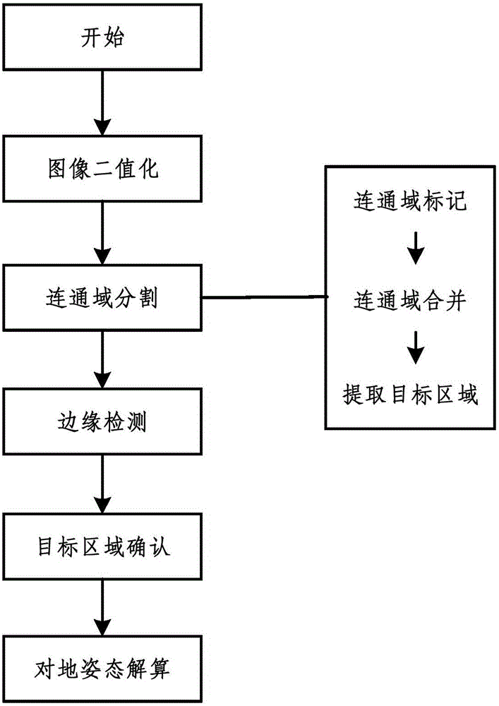
[0053] The present invention proposes a method for calculating the attitude to the ground based on the area method, such as figure 1 As shown, it spe...


PUM


Abstract

The present invention discloses an area method-based to-ground attitude calculation method, and belongs to the spacecraft navigation, guidance and control field. The method comprises the following steps of 1 carrying out the image binaryzation operation; 2 marking and merging the connected domains, and extracting a maximum connected domain; 3 extracting edges and utilizing the target characteristics to further confirm a target connected domain; 4 calculating the to-ground attitudes. The area method-based to-ground attitude calculation method provided by the present invention has a good effect on the conditions that the noise points are more, other interference target areas are less than a to-be-extracted target, and a to-be-extracted target area is more normative.

Description

technical field [0001] The invention belongs to the field of navigation, guidance and control of spacecraft, and in particular relates to a method for calculating an attitude to the ground based on an area method. Background technique [0002] As an attitude sensor that was first used in the aerospace field, the infrared horizon has always been an important part of various satellite attitude and orbit control systems. According to the working method, the infrared horizon can be divided into dynamic horizon and static horizon. The conical scanning dynamic horizon is a kind of dynamic horizon, which is realized by scanning around a fixed axis. This horizon includes mechanical scanning. device, so the volume is relatively large, the power consumption is also high, and the measurement accuracy is low. [0003] In the early 1990s, with the development of small satellite technology, the requirements for infrared horizons were increasing, and infrared horizons gradually developed ...

Claims


Application Information

Patent Timeline
Patent Type & Authority Applications(China)
IPC IPC(8): G06T7/00G01C11/04G01C21/00
CPCG01C11/04G01C21/00G06T2207/10048G06T2207/30181
Inventor 伍玲玲窦伟郑循江井丽红庞欢
Owner SHANGHAI AEROSPACE CONTROL TECH INST
Learn More