Urban indoor and outdoor integration three-dimensional scene construction and space adaptive navigation method

A three-dimensional scene and navigation method technology, applied in the field of signal and information processing, can solve the problems of no scene interaction, reduced modeling workload, and low model fidelity, so as to improve modeling efficiency, reduce modeling workload, and improve The effect of decision-making efficiency

Inactive Publication Date: 2016-11-09
NANJING FORESTRY UNIV
View PDF3 Cites 14 Cited by
  • Summary
  • Abstract
  • Description
  • Claims
  • Application Information

AI Technical Summary

Problems solved by technology

[0005] Using a hybrid modeling method based on geometry and images, the two modeling methods of using ALS point cloud data to build a city surface model and using a modeling system to build an indoor scene are combined to build an integrated urban indoor and outdoor model and make it go through layered scenes Rendering solves the problems of low fidelity of traditional models and no scene interaction, and greatly improves the modeling efficiency without losing the accuracy of the model; in addition, the development of the modeling system and the texture database The creation of the system makes the system more suitable for indoor modeling of urban buildings, thereby greatly reducing the modeling workload; after the model is completed, the present invention integrates the optimized urban indoor and outdoor integrated 3D model into the GoogleEarth platform to facilitate positioning

Method used


Image

  • Urban indoor and outdoor integration three-dimensional scene construction and space adaptive navigation method
  • Urban indoor and outdoor integration three-dimensional scene construction and space adaptive navigation method
  • Urban indoor and outdoor integration three-dimensional scene construction and space adaptive navigation method

Examples


Embodiment Construction

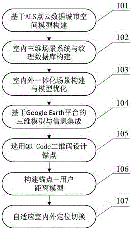
[0016] A three-dimensional scene construction and space adaptive navigation method for urban indoor and outdoor integration, including the following steps:

[0017] (1) Construction of urban space model based on ALS point cloud data;

[0018] (2) Indoor 3D scene system and texture database construction;

[0019] (3) Indoor and outdoor integrated scene construction and model structure optimization;

[0020] (4) 3D model and information integration based on Google Earth and SketchUp platforms;

[0021] (5) Choose the QR Code two-dimensional code to design the anchor point;

[0022] (6) Build an anchor point-user distance model;

[0023] (7) Adaptive indoor and outdoor positioning switching.

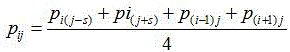
[0024] The step (1) is based on the construction of the urban space model of ALS point cloud data: use the threshold limit algorithm and Gaussian filter algorithm to eliminate the point cloud elevation abnormal points and noise points, filter and smooth the point cloud, data registratio...


PUM


Abstract

The invention discloses an urban indoor and outdoor integration three-dimensional scene construction and space adaptive navigation method, which comprises the following steps: on the basis of ALS (Approach and Landing Simulator) point cloud data, constructing an urban space model; creating an indoor three-dimensional scene system and a texture database; carrying out indoor and outdoor integration scene construction and model structure optimization: carrying out three-dimensional model and information integration based on Google Earth and SketchUP platforms; selecting a QR (Quick Response) Code two-dimensional code to design an anchor point; constructing an anchor point-user distance model; and carrying out adaptive indoor and outdoor positioning switching. The method has the advantages that an urban indoor and outdoor integration model is constructed by the ALS cloud point data, an accurate indoor and outdoor space scene is constructed and integrated on the Google Earth platform by a modeling system, WiFi and a two-dimensional code technology are combined to develop an indoor and outdoor space adaptive navigation service, the construction of the urban indoor and outdoor integration three-dimensional scene model and indoor and outdoor real-time positioning are realized, positioning accuracy is high, and space positioning information is provided.

Description

technical field [0001] The invention relates to a three-dimensional indoor and outdoor integrated scene construction and space self-adaptive navigation method, which belongs to the field of signal and information processing. Background technique [0002] With the intensification of urbanization and the continuous expansion of urban space, people's indoor activities are increasing and the demand for indoor three-dimensional scene construction, indoor and outdoor space positioning and navigation is increasing. Therefore, for relatively complex indoor environments such as large libraries, commercial centers, basements, and garages, high-quality indoor and outdoor 3D scene construction and spatial navigation services are particularly important. Accurate 3D scene models and indoor and outdoor space navigation are important components of digital cities. The use of 3D models in navigation services can enhance the realism and readability of the models, thereby better meeting the pos...

Claims


Application Information

Patent Timeline
Patent Type & Authority Applications(China)
IPC IPC(8): G06T17/05
CPCG06T17/05
Inventor 杨强石晓芸钱厚童郑加柱王志杰
Owner NANJING FORESTRY UNIV
Why Eureka
Try Eureka