Underwater topographic mapping and correcting method adopting AUV (autonomous underwater vehicle) equipped with multi-beam sonar

An underwater topography and multi-beam technology, applied in surveying and navigation, surveying devices, cross-section drawing, etc., can solve problems such as unrealistic topography and landform surveying operations

Active Publication Date: 2016-11-16
HARBIN ENG UNIV
View PDF7 Cites 39 Cited by
  • Summary
  • Abstract
  • Description
  • Claims
  • Application Information

AI Technical Summary

Problems solved by technology

Due to the need to communicate with shore-based units, the effective working water depth of this method is about 100 meters, and it is impossible to realize topographic and geomorphic survey operations in deep water areas

Method used


Image

  • Underwater topographic mapping and correcting method adopting AUV (autonomous underwater vehicle) equipped with multi-beam sonar
  • Underwater topographic mapping and correcting method adopting AUV (autonomous underwater vehicle) equipped with multi-beam sonar
  • Underwater topographic mapping and correcting method adopting AUV (autonomous underwater vehicle) equipped with multi-beam sonar

Examples


Embodiment Construction

[0036] The present invention will be further described in detail below in conjunction with the accompanying drawings and specific embodiments.

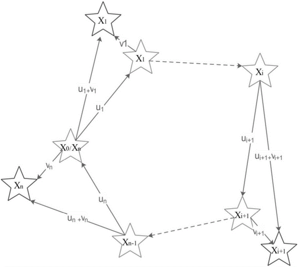
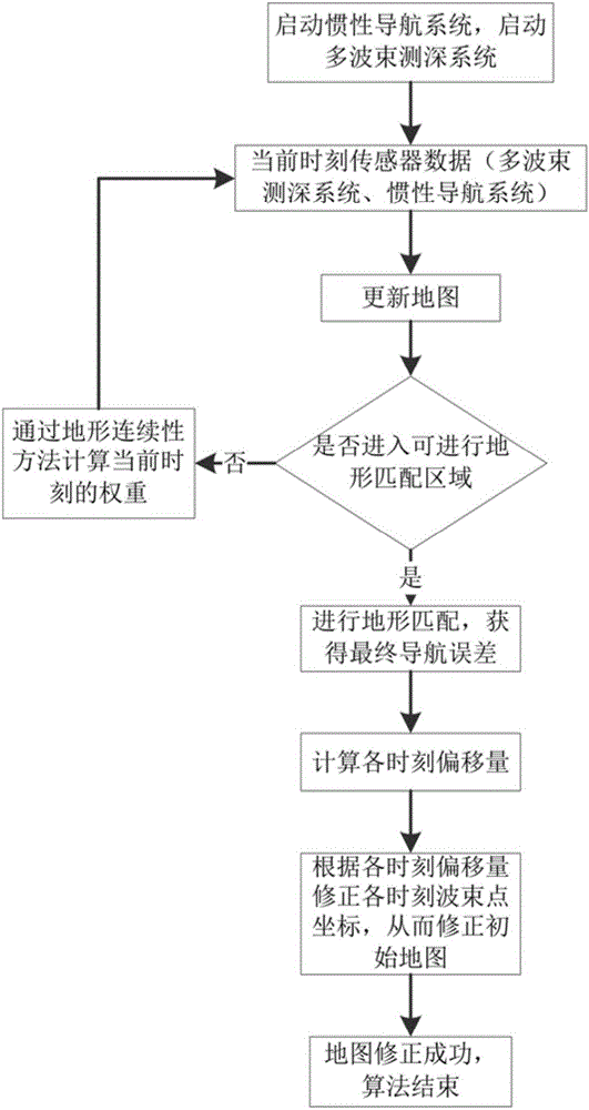
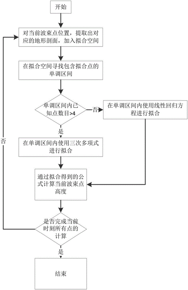
[0037] The purpose of the present invention is to provide a seabed topography correction method capable of carrying multi-beam sonar on an AUV, including front-end map construction and back-end map correction, first start the multi-beam bathymetry system to collect terrain data, and start the inertial navigation system to collect estimated positions data. The accurate relative position between the head and the tail is determined by the terrain matching method, and the estimated relative position of the head and the tail is given by the inertial navigation, so as to obtain the final navigation error of the tail inertial navigation system. The inertial navigation system is simplified as a spring model, and the relationship between each node error and the actual final navigation error is calculated through the stiffness coefficient formu...


PUM


Abstract

The invention provides an underwater topographic mapping and correcting method adopting an AUV (autonomous underwater vehicle) equipped with multi-beam sonar. The method comprises steps as follows: multi-beam sonar and a depth gauge are started to collect data, and each ping is corrected according to sound velocity information collected by a sound velocity section plotter; an accurate relative position between two moments is determined with a topographic matching method, so that a final navigation error of an inertial navigation system is obtained; the inertial navigation system is simplified into a spring model, a relationship between each node error and an actual final navigation error is calculated according to a stiffness coefficient formula of a spring; weight of each time node relative to the final error is determined with a topography continuity method; a final moment error is distributed to each time node. The method is independent of GPS (global position system) information in a submarine topographical map establishing process, the multi-beam sonar can be carried by the AUV for completing submarine topographic mapping of a deeper sea area, the consistency of an established map is better, the time node error is small, and the submarine topographical map can be taken as a priori topography map to be applied to the underwater topographic matching navigation.

Description

technical field [0001] The invention relates to a seabed terrain surveying and mapping correction method carried by an AUV equipped with multi-beam sonar, and belongs to the technical field of surveying and mapping of seabed topography. Background technique [0002] With the development of multi-beam technology, the application of high-precision seabed topographic mapping and underwater robot terrain matching navigation technology becomes possible. Terrain matching for underwater robots relies on the construction of a priori map of the seabed. The current seabed map construction method usually scans the seabed terrain by ship-borne multi-beam sonar, but due to the limitation of the length of the multi-beam sonar survey line, it is impossible to complete the topographic mapping of deep sea areas. [0003] At present, the existing multi-beam submarine topographic mapping methods all need to rely on the communication with GPS satellites or shore-based units, which not only inc...

Claims


Application Information

Patent Timeline
Patent Type & Authority Applications(China)
IPC IPC(8): G01C7/00G01C21/16
CPCG01C7/00G01C21/165
Inventor 李晔马腾王汝鹏陈鹏云郭宏达张强安力张蔚欣龚昊
Owner HARBIN ENG UNIV
Why Eureka
Try Eureka