City planning method utilizing open-type sunken road

A kind of urban planning and open technology, applied in the direction of roads, roads, water conservancy projects, etc., can solve the urban spatial form and landscape, the adverse effects of residents' life along the line, the lack of systematic and scientific integrated planning, and the large ground space occupied by viaducts, etc. problems, to achieve the effect of intensive utilization of urban space, improvement of traffic efficiency and reachable area, and reduction of ground floor area

Inactive Publication Date: 2016-12-07
PLA UNIV OF SCI & TECH
View PDF5 Cites 6 Cited by
  • Summary
  • Abstract
  • Description
  • Claims
  • Application Information

AI Technical Summary

Problems solved by technology

However, both the construction of viaducts and the development of underground space have shown certain deficiencies.
In terms of viaduct construction, although the construction of viaducts is relatively less than that of underground tunnels, viaducts still occupy a large amount of ground space, which has a relatively large adverse impact on the urban spatial form and landscape, and the lives of residents along the line. There are even viaducts to be built. The case of dismantling and changing to an underground tunnel
In terms of underground space development, the traditional urban planning theory focuses on the planning of ground space, often regards underground space as its subsidiary space, and lacks systematic and scientific integrated planning. Therefore, underground space is mostly developed separately after the construction of ground space is completed. Due to the limitation of ground buildings, the difficulty of construction increases, and the capital investment doubles. Moreover, the traditional underground space is mostly closed space. Due to the lack of natural lighting and ventilation, it not only has a negative impact on people's psychology, but also needs to rely on power equipment for air exchange.

Method used


Image

  • City planning method utilizing open-type sunken road
  • City planning method utilizing open-type sunken road
  • City planning method utilizing open-type sunken road

Examples


Embodiment Construction

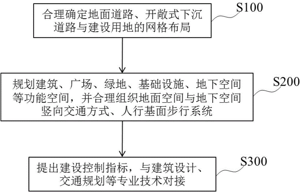
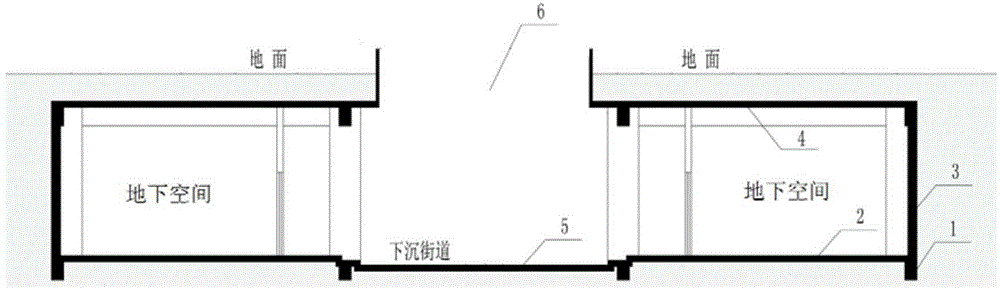
[0020] The basic concept of the present invention is to use the dislocation of the ground road and the open sunken road in the horizontal direction and the layering in the vertical direction to form a continuous three-dimensional traffic pattern. Conditions have certain requirements. Therefore, before using the method of the present invention for urban planning, it is necessary to investigate the topography, geological structure, and architectural status of the planned land in the overall urban planning, to demonstrate the feasibility of the planning method of the present invention for the planned land, and to clarify the content of planning control . The survey content mainly includes the distribution of mountains and lakes, river direction, groundwater level, geological structure, existing buildings, and historical and cultural protection scope within the planned land use range and surrounding areas. After completing the survey of the planned land, the survey results need t...


PUM


Abstract

The invention provides a city planning method utilizing an open-type sunken road. The city planning method comprises the following steps of determining the layout of a ground road, an open-type sunken road and a construction land and forming a layered mesh city pattern, by combining the topography and geomorphology as well as the existing buildings in a planning land; planning buildings, squares, green lands, infrastructures and underground space in the planning land according to the requirements on the development goal, the population scale and the control index of a planning city in the overall city planning; and proposing the next-step construction control index for the obtained city functional space, and performing professional technical docking on the architectural design, transportation planning and municipal engineering. According to the city planning method disclosed by the invention, the open-type sunken road is utilized, so that the ground road and the open-type sunken road form staggered layers to realize the functions of separation of pedestrians from vehicles, natural lighting and ventilation of underground space, and the like, and not only is the city development space expanded, but also the environmental quality of the underground space of the city is improved.

Description

technical field [0001] The invention belongs to the technical field of urban planning and design, and specifically relates to an integrated planning and design of urban ground space and underground space based on the concept of urban multi-level bases, using open sunken roads, so as to realize natural lighting and natural lighting in underground spaces. Urban planning methods for ventilation, pedestrian and vehicle diversion. Background technique [0002] As my country's urbanization process continues to accelerate, a large number of people flock to cities, and the limited ground space will not be able to meet the needs of urban development. Many cities have to varying degrees experienced limited space development, deterioration of the natural environment, traffic congestion, Serious shortage of public infrastructure and other increasingly prominent problems. These problems not only hinder the sustainable development of modern cities, but also affect people's life, travel, w...

Claims


Application Information

Patent Timeline
Patent Type & Authority Applications(China)
IPC IPC(8): E01C1/04E02D29/045
CPCY02A30/60
Inventor 苏理昌陈志龙陈家运张平朱星平祖欣园
Owner PLA UNIV OF SCI & TECH
Why Eureka
Try Eureka