Mine MWD exploration system and measurement method thereof

A technology of inclination-while-drilling and exploration systems, applied in seismology and construction for well logging records, can solve problems such as cost increase, seismic wave signal weakening, information acquisition lag, etc., to reduce time and engineering quantity, signal The effect of improving the signal-to-noise ratio and improving the prediction accuracy

Active Publication Date: 2016-12-07
ANHUI HUIZHOU GEOLOGY SECURITY INST
View PDF8 Cites 22 Cited by
  • Summary
  • Abstract
  • Description
  • Claims
  • Application Information

AI Technical Summary

Problems solved by technology

However, there are many deficiencies in drilling: (1) Due to factors such as construction deviation, lithological changes, and structural development, the actual trajectory of the drilling hole is quite different from the design, and it is difficult to reach the target formation, so that it is impossible to accurately grasp the geology of the target area (2) Drilling is often only a "one-hole view", and it is difficult to effectively detect the geological and hydrological conditions in front of and around the drilling hole; (3) Conventional drilling requires coring to conduct lithology and geological analysis. The identification and judgment of the structure requires a large workload and high cost. When the geological conditions are poor, the coring rate will be low, and there may even be a risk of drilling accidents; The lithology is judged only by experience, the accuracy is not high, and it lacks continuity and record
As an important part of coal mine drilling process control, drilling quality inspection has been paid more and more attention. For this reason, a number of technologies and instruments with the functions of drilling space trajectory measurement and drilling inside peeping have been developed and applied to understand the drilling space. Orientation, hole quality, hole structure and lithology, etc. However, due to the need for secondary measurement after the drilling construction is completed, the information acquisition is relatively lagging, resulting in poor timeliness, time-consuming and cost-intensive
In order to improve this problem, the industry has proposed a technical solution for inclination measurement while drilling (such as the invention patent with the publication number CN105735970A), that is, during drilling, the probe tube in the hole is used to simultaneously measure the spatial trajectory and orientation of the borehole, but drilling construction is still required. After exporting the data into a map, real-time drawing display cannot be performed on site, and it is limited to obtaining the spatial orientation trajectory of the borehole
There is also a technical proposal to adopt a method similar to ground seismic while drilling (such as the utility model patent with the publication number CN204631261U), using the vibration signal of the drill bit as the source of vibration, and installing the geophones on the top of the drill pipe and the side wall respectively to detect the side wall and the side wall. Geological conditions in front of the drill bit, but it does not have the function of inclination measurement while drilling, which will make it difficult for the offset imaging results to correspond to the actual spatial position. etc.), so that the interference is seriously affected, and the effective seismic wave signal is seriously weakened

Method used


Image

  • Mine MWD exploration system and measurement method thereof
  • Mine MWD exploration system and measurement method thereof
  • Mine MWD exploration system and measurement method thereof

Examples


Embodiment 1

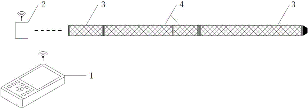
[0041] Such as figure 1 As shown, the mine inclinometer-while-drilling exploration system of this embodiment includes a measurement module, a communication device 2 and a hand-held terminal 1 . The measurement module is installed behind the drill bit 5 and is propelled by the drill rod 6, and directly uses the vibration generated by the drill bit 5 breaking rock as a seismic source.

[0042] The measuring module includes a measuring probe 4 and non-magnetic rods 3 installed at the front and rear ends of the measuring probe 4 . The measuring probe 4 is used for signal acquisition in the hole and plays the role of transmission and water passage at the same time. The non-magnetic rod 3 is used to isolate the magnetic interference generated by the drill pipe 6 on the measurement probe 4, and also has the function of transmission and water passage. The communication device 2 is installed in the drilling field outside the hole to realize the communication between the measuring prob...

Embodiment 2

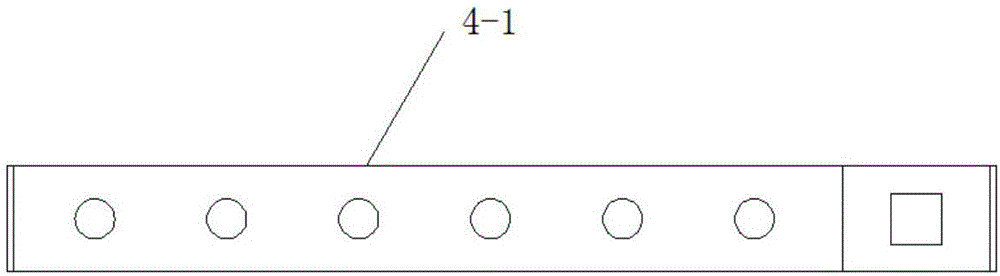
[0045] Such as figure 2 As shown, the seismic measurement module 4-1 adopts two sets of geophone groups, a three-component geophone group and a small array geophone group. Among them, the three-component geophone group is used to detect vibration signals in real time, and controls the on and off status of the inclinometer module and the small array geophone group through the threshold and time, and the small array geophone group is arranged with 6 geophones, and the track spacing is 0.05. -0.3m, as the measurement of discontinuous dynamic signals, observe the seismic direct wave, reflected wave, diffracted wave and other signals excited by the rock breaking of the drill bit 5 and propagated through the drill bit 5 / drill pipe 6 and the surrounding rock of the borehole.

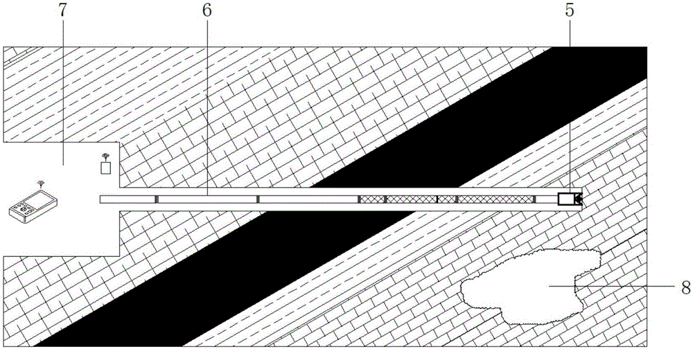
[0046] by Figure 3-Figure 7 As an example to illustrate a kind of applicable measurement-while-drilling method based on the composition, characteristics and drilling construction of the system of the present...


PUM


Abstract

The invention discloses a mine MWD (Measurement While Drilling) exploration system and a measurement method thereof. The mine MWD exploration system comprises a measurement module, a communication device and a handheld terminal, wherein the measurement module is mounted at the back of a drill bit, is propelled by a drill rod, directly utilizes vibration generated when the drill bit breaks rocks as a vibration source, and comprises a measurement probe tube as well as non-magnetic rods mounted at the front end and the back end of the measurement probe tube; the measurement probe tube is used for collecting signals in a hole, and meanwhile plays the transmission and water flowing functions; the non-magnetic rods are used for isolating the magnetic interference generated by the drill rod to the measurement probe tube, and also have the transmission and water flowing functions; the communication device is mounted in a drill site outside the hole to realize communication between the measurement probe tube and the handheld terminal. According to the mine MWD exploration system and the measurement method thereof, the occurrence of the drill hole and a rock dynamic action spectrum of the drill bit can be measured while drilling, a drilling space trajectory and the drilling meeting rock property are provided, meanwhile the purpose of exploration while drilling can be realized, and the fact that various conditions can be measured in one hole can be realized.

Description

technical field [0001] The invention belongs to the field of mine engineering drilling, in particular to in-situ measurement-while-drilling for drilling inclination measurement and lithology judgment, and in particular to a mine inclinometer-while-drilling exploration system and a measurement method thereof. Background technique [0002] Seismic While Drilling (SWD, Seismic While Drilling) is an interdisciplinary new technology developed on the basis of traditional surface seismic measurement methods and vertical seismic profiling (VSP) combined with drilling engineering. The principle is to use the rock-breaking vibration of the drill bit as the seismic source to obtain a variety of formation parameters during the drilling process, determine the position of the drill bit on the seismic profile and predict the formation pressure in front of the drill bit, so as to guide the adjustment of the drilling plan to reduce drilling risks. Oil and gas exploration and development are ...

Claims


Application Information

Patent Timeline
Patent Type & Authority Applications(China)
IPC IPC(8): E21B47/0228G01V1/44
CPCG01V1/44E21B47/0228Y02A90/30
Inventor 刘惠洲周官群倪圣军郝志超吴昭胡斌陈浩国居龙泉李继伟
Owner ANHUI HUIZHOU GEOLOGY SECURITY INST
Why Eureka
Try Eureka