Three-laser mark point image-based tunnelling machine positioning system and positioning method

A positioning system and laser marking technology, which is applied in the field of positioning system design of roadheaders and positioning control of engineering robots, can solve problems such as the impact of detection accuracy, avoid error accumulation, simple and easy positioning methods, and reduce use and maintenance costs Effect

Active Publication Date: 2016-12-14
SHANGHAI JIAO TONG UNIV
View PDF4 Cites 13 Cited by
  • Summary
  • Abstract
  • Description
  • Claims
  • Application Information

AI Technical Summary

Problems solved by technology

The difficulty lies in how to overcome the impact of harsh working conditions on the wo

Method used


Image

  • Three-laser mark point image-based tunnelling machine positioning system and positioning method
  • Three-laser mark point image-based tunnelling machine positioning system and positioning method
  • Three-laser mark point image-based tunnelling machine positioning system and positioning method

Examples


Embodiment Construction

[0036] The present invention will be described in detail below in conjunction with specific embodiments. The following examples will help those skilled in the art to further understand the present invention, but do not limit the present invention in any form. It should be noted that those skilled in the art can make several changes and improvements without departing from the concept of the present invention. These all belong to the protection scope of the present invention.

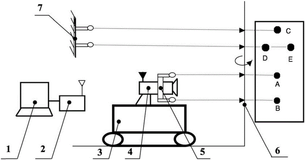
[0037] like figure 1 As shown, a roadheader positioning system based on three laser marking point images provided by the present invention includes: a wireless camera, a wireless base station, a computer terminal, a triangle laser marker, and a two-point laser marker; the computer terminal passes through the wireless base station Receive the image of the reference surface of the tunneling roadway collected by the wireless camera; the relative position of the triangular laser marker and the tunneling roa...


PUM


Abstract

The invention provides a three-laser mark point image-based tunnelling machine positioning system. The system comprises a wireless camera, a wireless base station, a computer, triangular laser markers and a two-point laser maker; the wireless camera is mounted on a tunnelling machine; the triangular laser markers are uniformly distributed and mounted on the circumference of the camera; the wireless camera is wirelessly connected with the wireless base station; the wireless base station is connected with the computer through a cable; the two-point laser maker is mounted on the ground surface of a tunnelling roadway. Meanwhile, the invention also provides a positioning method for the positioning system. Compared with the prior art, the positioning system and the positioning method have the characteristics of compact structure, simplicity, feasibility, accurate positioning and the like; supporting conditions are provided for unmanned remote visible teleoperation of the tunnelling machine.

Description

technical field [0001] The invention relates to the field of positioning system design of a roadheader and positioning control of an engineering robot, in particular to a roadheader positioning system and a positioning method based on images of three laser marking points. Background technique [0002] At present, a variety of positioning technologies are used in the positioning system of roadheaders, including positioning systems based on total stations, positioning technologies based on strapdown inertial systems, positioning systems based on laser guidance, and roadheader guidance and positioning systems based on visual measurement. [0003] The total station is called a total station electronic speedometer. The positioning and guidance technology based on the total station has been used for the guidance of the shield boring machine tunnel excavation many years ago. It is a measuring instrument that can perform angle measurement, distance measurement and data processing at...

Claims


Application Information

Patent Timeline
IPC IPC(8): G01C15/00
CPCG01C15/00G01C15/002
Inventor 王坤东陈冰孙强张佃龙
Owner SHANGHAI JIAO TONG UNIV
Why Eureka
Try Eureka