

A GPS Dynamic and Accurate Positioning Method Suitable for Plateau Alpine Areas
A technology for precise positioning in alpine regions, applied in positioning, measuring devices, instruments, etc., to achieve the effect of improving reliability and accuracy, increasing inspection conditions, and improving operational efficiency
Inactive Publication Date: 2012-05-02
中国人民解放军兰州军区测绘信息中心
View PDF0 Cites 4 Cited by
- Summary
- Abstract
- Description
- Claims
- Application Information
AI Technical Summary
Problems solved by technology
The purpose of the present invention is to provide a GPS dynamic and accurate positioning method suitable for the western plateau and high areas, effectively overcome the problem of low operating efficiency caused by blind areas of RTK signals and RTG signals, improve operating efficiency, and reduce the labor intensity of operators
Method used
View moreImage
Smart ImageViewing Examples

Examples
Embodiment Construction
Login to View More PUM
 Abstract
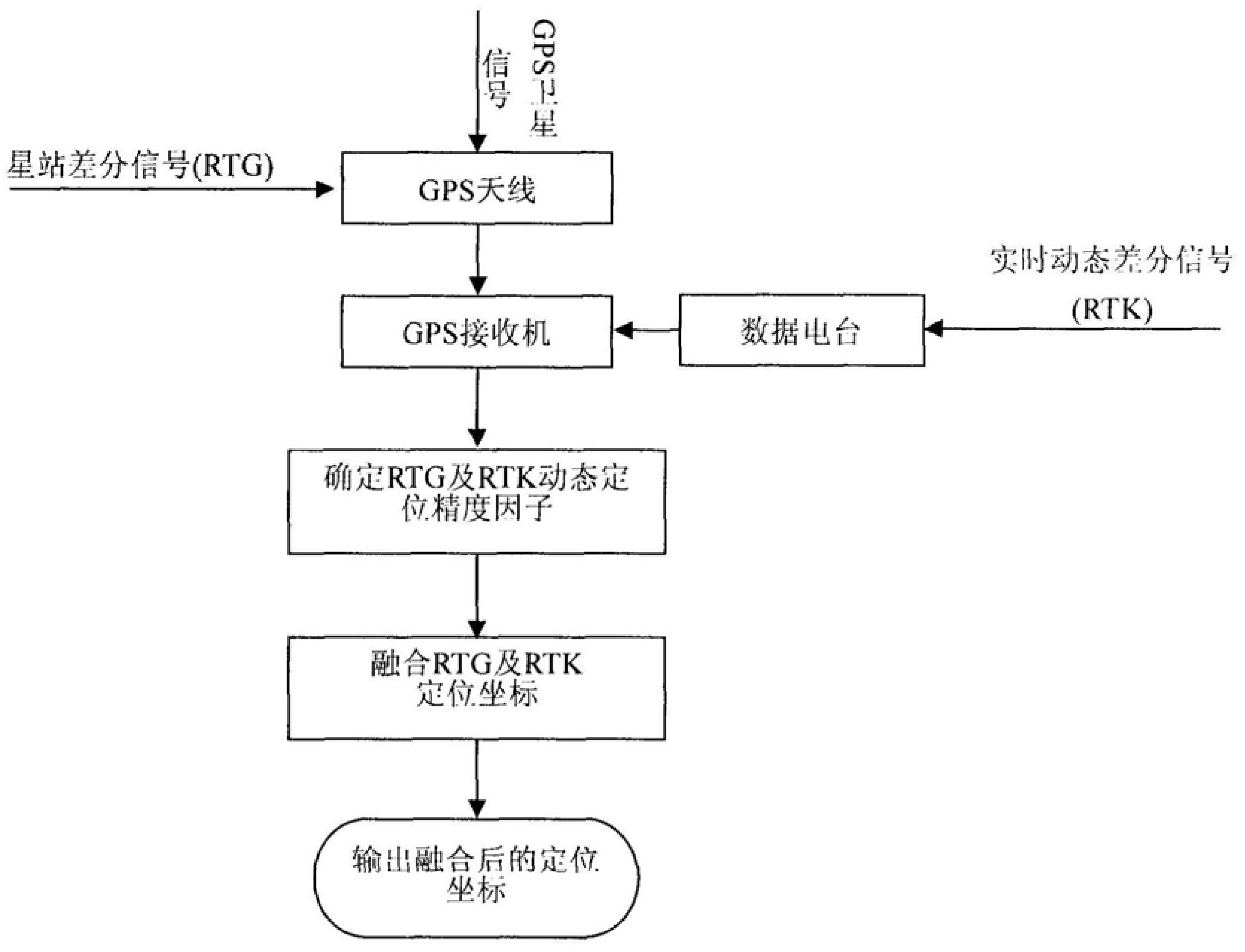
The invention provides a GPS dynamic and precise positioning method in plateau alpine regions, belonging to the technical field of radio orientation. This method adopts the RTK+RTG joint working mode, and through the software and hardware interfaces, the GPS receiver receives the star station differential signal (RTG) and the carrier phase differential signal (RTK) while receiving the GPS signal. Correct the positioning coordinates directly; determine the precision factor of RTK dynamic positioning and the precision factor of RTG dynamic positioning; integrate RTG positioning coordinates and RTK positioning coordinates, this method effectively overcomes the problem of low operating efficiency caused by RTK signals or RTG signal blind areas. The GPS dynamic and accurate positioning method provided by the invention can be applied to fast navigation and positioning, line survey, line measurement, fast topographic map repair and measurement, large-scale topographic map measurement and production, and the like.
Description
A GPS Dynamic and Accurate Positioning Method Suitable for Plateau Alpine Regions technical field The invention relates to a dynamic precise positioning method, in particular to GPS dynamic precise positioning in plateau alpine regions. Background technique GPS technology GPS (Global Positioning System) is a new generation of space satellite radio navigation and positioning system developed by the US Department of Defense in the 1970s. It can provide real-time, all-weather and global three-dimensional position, three-dimensional velocity and high-precision time information. GPS system The establishment of the surveying and mapping work provides a new means of positioning and measurement. The GPS navigation message includes two kinds of pseudo-random codes, which are civilian C / A code and military P(Y) code. The accuracy of C / A code is about 20 meters, and the accuracy of P(Y) code is about 2 meters. about. According to the usability policy and anti-spoofing (Anti-Spoof...
Claims
Login to View More Application Information
Patent Timeline
 Patent Type & AuthorityPatents(China)
IPC IPC(8): G01S5/02
Inventor王明孝马延敏刘兴科董北平梁红马怀武申亚鹏刘锐宋福胜张之孔白正兵张海波管宁翟辉琴黄超峰
Owner中国人民解放军兰州军区测绘信息中心