Supercharge Your Innovation With Domain-Expert AI Agents!

Evaluation method of lake water storage variables based on multi-temporal remote sensing images and dem

A technology of remote sensing images and satellite remote sensing images, which is applied in the field of lake water storage variable evaluation based on multi-temporal remote sensing images and DEM, can solve problems such as climate change and water cycle evolution in difficult areas, and lack of lake water changes, and achieve socially sustainable The effect of sustainable development

Inactive Publication Date: 2018-02-09
CHINA INST OF WATER RESOURCES & HYDROPOWER RES +1
View PDF2 Cites 0 Cited by
  • Summary
  • Abstract
  • Description
  • Claims
  • Application Information

AI Technical Summary

Problems solved by technology

[0003] At present, the research on the evolution of lakes mainly focuses on the change of lake water surface area, which is achieved by extracting lake images of different ages through satellite remote sensing technology, analyzing and calculating the area to determine the extent of lake expansion or shrinkage; the research on lake water volume changes is briefly There is a shortage. At present, artificial field surveying and mapping, that is, water balance and model simulation methods are generally used to calculate the lake water volume. In these two methods, there are different degrees of uncertainty in the calculation of other water elements except lake water. Difficult to provide support for research on regional climate change and water cycle evolution

Method used


Image

  • Evaluation method of lake water storage variables based on multi-temporal remote sensing images and dem
  • Evaluation method of lake water storage variables based on multi-temporal remote sensing images and dem
  • Evaluation method of lake water storage variables based on multi-temporal remote sensing images and dem

Examples


Embodiment

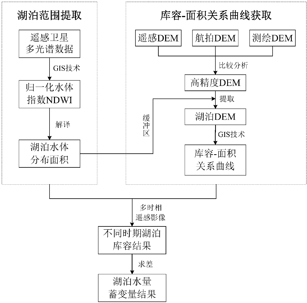
[0054] Combine below figure 2 and image 3 The Namtso Lake in my country's Qinghai-Tibet Plateau is selected as an example to illustrate the lake water storage variable evaluation method provided by the present invention:

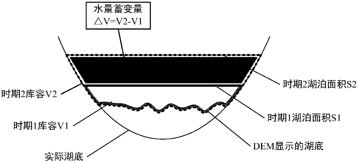
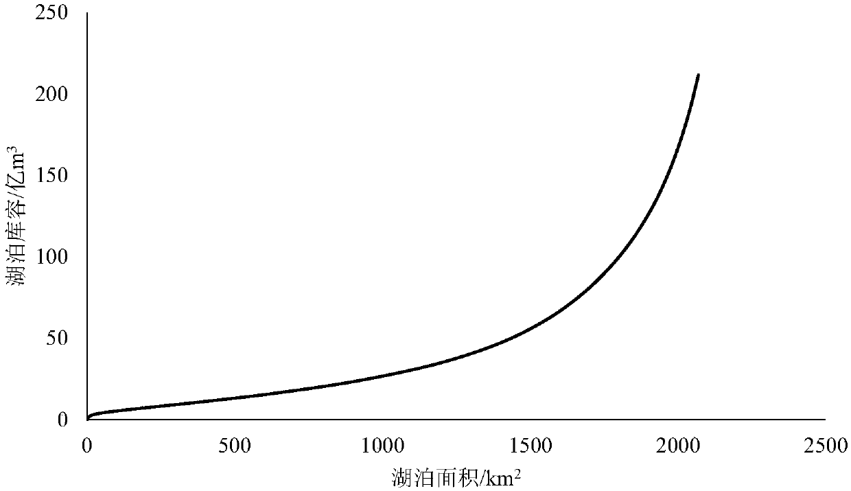
[0055] In the evaluation process, two time periods were selected as the 90s and 00s to evaluate the water storage variables from the 90s to the 00s; in this example, the Landsat-5TM image on October 13, 1996 and the November Landsat-7ETM image on March 1st; then the area of ​​Namtso Lake in the 1990s and 2000s using the lake water storage variable assessment method, the storage capacity-area relationship curve of the depression where Namtso Lake is located in the 1990s and 2000s, and through the 90s and 00s The area of ​​Namtso Lake and its storage capacity-area relationship curve obtained the storage capacity of Namtso Lake in the 1990s and 2000s; finally, the storage variables of Namtso Lake between the 90s and 00s were obtained.

[0056] Table 1 shows...


PUM


Abstract

The invention discloses a lake water volume storage variable assessment method based on a multi-temporal remote-sensing image and a DEM. The lake water volume storage variable assessment method comprises the following steps that (A) the lake areas in a current region within two time periods are calculated; (B) a reservoir capacity-area relation curve of the depression where a lake is located in the current region within two time periods is calculated; (C) the lake areas in the current region within the two time periods and the reservoir capacity-area relation curve of the lake corresponding to the lake areas are read to obtain the water storage capability of the lake in the current time period; (D) the difference of the reservoir capacities of the lake within two time periods is calculated to serve as a lake water volume storage variable. According to the scheme, quantified description of the shrinking or expanding degree of the lake can be achieved based on the calculated water volume storage variable, the lake water volume storage variable assessment method has the important significance on climatic change research and regional water resource evolution tendency, and meanwhile the lake water storage capability change has a certain supporting effect on the research of water circulation elements of a drainage basin and is conductive to social sustainable development.

Description

technical field [0001] The invention relates to a method for evaluating lake water storage variables in two time periods, in particular to an evaluation method for lake water storage variables based on multi-temporal remote sensing images and DEM. Background technique [0002] Lakes participate in the natural water cycle and are extremely sensitive to climate changes. Changes in the area and water content of lakes will change the conditions of the underlying surface, thereby affecting atmospheric circulation. Therefore, lakes can be used as indicators of regional climate change to a certain extent; Lakes also have multiple functions such as regulating runoff, providing water, and improving regional ecological environment; therefore, it is of great significance to the study of lake evolution. [0003] At present, the research on the evolution of lakes mainly focuses on the change of lake water surface area, which is achieved by extracting lake images of different ages through...

Claims


Application Information

Patent Timeline
Patent Type & Authority Patents(China)
IPC IPC(8): G06F19/00G01F22/00
CPCG01F22/00G16Z99/00
Inventor 秦天玲李蒙严登华史婉丽翁白莎苗欣慧刘少华
Owner CHINA INST OF WATER RESOURCES & HYDROPOWER RES
Features
  • R&D
  • Intellectual Property
  • Life Sciences
  • Materials
  • Tech Scout
  • Unparalleled Data Quality
  • Higher Quality Content
  • 60% Fewer Hallucinations
Learn More