Method and system for inverting ground PM 2.5 through combination of geostatistical interpolation and satellite remote sensing

A kind of PM2.5, satellite remote sensing technology, applied in the direction of measuring device, suspension and porous material analysis, particle suspension analysis, etc., can solve the problem of low estimation accuracy of regional PM2.5, to make up for the inability to estimate and improve the estimation accuracy Effect

Inactive Publication Date: 2017-02-15
INST OF REMOTE SENSING & DIGITAL EARTH CHINESE ACADEMY OF SCI
View PDF2 Cites 23 Cited by
  • Summary
  • Abstract
  • Description
  • Claims
  • Application Information

AI Technical Summary

Problems solved by technology

[0007] In view of the above problems, the object of the present invention is to provide a method and system for jointly inverting ground PM2.5 by geostatistical

Method used


Image

  • Method and system for inverting ground PM 2.5 through combination of geostatistical interpolation and satellite remote sensing
  • Method and system for inverting ground PM 2.5 through combination of geostatistical interpolation and satellite remote sensing

Examples


Example Embodiment

[0022] The specific embodiments of the present invention will be described in detail below with reference to the accompanying drawings.

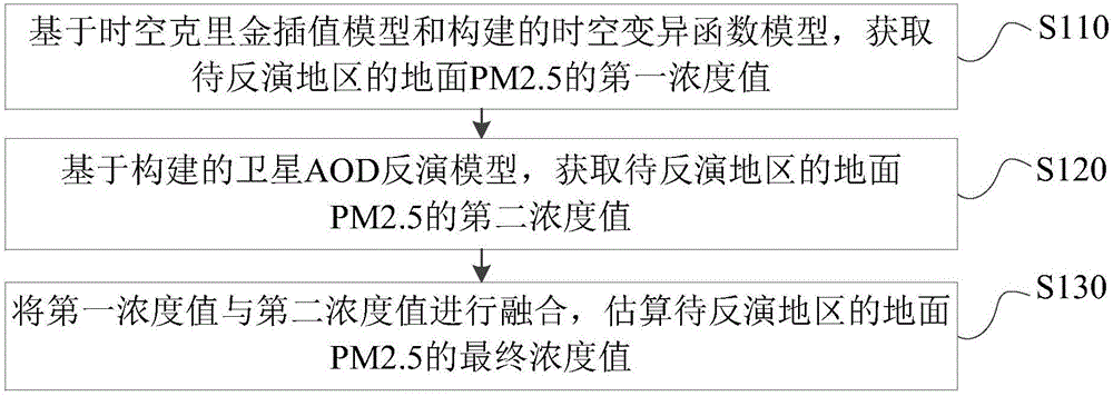
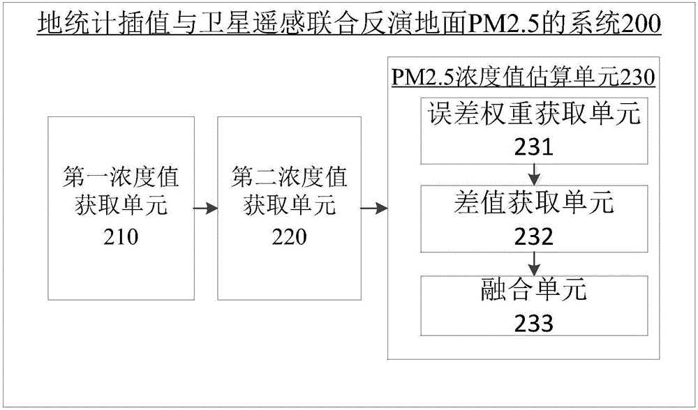
[0023] Aiming at the problem that the estimation accuracy of the regional PM2.5 by the existing estimation methods is not high, the present invention combines the space-time kriging interpolation model in the geostatistical interpolation model with satellite remote sensing, and combines the two models according to the error weight. The estimation results are fused, which can not only ensure the estimation accuracy of PM2.5, but also make up for the disadvantage that PM2.5 cannot be estimated at the missing AOD.

[0024] Before describing the present invention, the concepts and terms involved in the present invention are explained.

[0025] In the present invention, the MODerate-resolution Imaging Spectroradiometer (MODerate-resolution Imaging Spectroradiometer, MODIS for short) sixth edition (C6) satellite remote sensing AOD data on the NASA...


PUM


Abstract

The invention provides a method and system for inverting the ground PM 2.5 through combination of geostatistical interpolation and satellite remote sensing. The method comprises: based on a space-time kriging interpolation model and a constructed space-time variogram model, obtaining a first concentration value of the ground PM 2.5 of a to-be-inverted region; based on a constructed satellite AOD inversion model, obtaining a second concentration value of the ground PM 2.5 of the to-be-inverted region; and fusing the first and second concentration values to estimate a final concentration value of the ground PM 2.5 of the to-be-inverted region. A weight relationship is established according to the root-mean-square error of the first and second concentration values, and the first and second concentration values are fused according to the weight relationship to estimate the final concentration value of the ground PM 2.5 of the to-be-inverted region. According to the method and system, the estimation accuracy of PM 2.5 is improved in a situation that ground monitoring stations are less, and the defect that PM 2.5 cannot be estimated at the place where AOD data is lost is overcome.

Description

technical field [0001] The invention relates to the technical field of aerosol monitoring, and more specifically, relates to a method and system for jointly inverting ground PM2.5 by geostatistical interpolation and satellite remote sensing. Background technique [0002] With the rapid development of the economy, industrial activities and man-made emissions of harmful gases such as vehicle exhaust have increased sharply, resulting in continuous deterioration of air quality. PM2.5 refers to particulate matter in the air with an aerodynamic particle size of less than 2.5 microns. Compared with large-size particles, PM2.5 has a small particle size, is rich in a large amount of toxic and harmful substances, has a long residence time in the atmosphere, and has a long transportation distance, so it has a great impact on the quality of the human body and the atmospheric environment. A large number of epidemiological studies have proved that there is a certain relationship between ...

Claims


Application Information

Patent Timeline
IPC IPC(8): G01N15/06
Inventor 陈良富李荣陶明辉王子峰陶金花
Owner INST OF REMOTE SENSING & DIGITAL EARTH CHINESE ACADEMY OF SCI
Why Eureka
Try Eureka