Laser imaging radar-based non-cooperative aircraft relative position posture measuring method

A technology of laser imaging radar and relative pose, which is applied in the direction of integrated navigator, etc., can solve the problems of short operating distance and poor environmental adaptability, and achieve the effect of strong anti-interference ability, good robustness, and broad prospect benefits

Active Publication Date: 2017-02-22
SHANGHAI AEROSPACE SYST ENG INST
View PDF2 Cites 20 Cited by
  • Summary
  • Abstract
  • Description
  • Claims
  • Application Information

AI Technical Summary

Problems solved by technology

The invention can solve the problems of poor environmental adaptability and short working distance in the traditional measurement system based on two-dimensional imaging sensors, and can realize the position and attitude measurement of non-cooperative spacecraft in space with any configuration, and meet the requirements of short-distance non-cooperative targets in space manipulation. Navigation Task Requirements

Method used


Image

  • Laser imaging radar-based non-cooperative aircraft relative position posture measuring method
  • Laser imaging radar-based non-cooperative aircraft relative position posture measuring method
  • Laser imaging radar-based non-cooperative aircraft relative position posture measuring method

Examples


Embodiment Construction

[0023] In the following description, specific details are set forth in order to provide a thorough understanding of the present invention. However, the present invention can be implemented in many other ways different from those described here, and those skilled in the art can make similar extensions without violating the connotation of the present invention, so the present invention is not limited by the specific implementations disclosed below.

[0024] Secondly, the present invention is described in detail by means of schematic diagrams. When describing the embodiments of the present invention in detail, for convenience of explanation, the schematic diagrams are only examples, which should not limit the protection scope of the present invention.

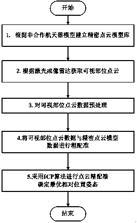
[0025] The invention provides a non-cooperative spacecraft relative pose measurement method based on laser imaging radar, which uses laser imaging radar to obtain point cloud data of visible parts of non-cooperative spacecraft, and...


PUM


Abstract

The invention provides a laser imaging radar-based non-cooperative aircraft relative position posture measuring method. A laser imaging radar is used as a measuring device to realize measurement of the relative posture of a non-cooperative aircraft having no obvious features. The method mainly comprises the following steps: 1, establishing a precise point cloud model library; 2, acquiring visible position cloud data by using the laser imaging radar; 3, preprocessing the visible cloud data; 4, carrying out coarse registration on the visible position cloud data and precise point cloud model data; and 5, carrying out point cloud precise registration by adopting an ICP algorithm to determine an optimal relative position posture. The method realizes measurement of the relative position posture of the non-cooperative aircraft with any configuration, and has the advantages of strong anti-interfere ability, good algorithm robustness, high relative position posture measurement precision and meeting of relative navigation task requirements of a short-distance non-cooperative target in space operation by establishing the point cloud database and reasonably selecting a point cloud to be registered.

Description

technical field [0001] The invention relates to a method for measuring the relative pose of a non-cooperative spacecraft based on laser imaging radar, in particular to a method for measuring the relative pose of a non-cooperative spacecraft without obvious features. Background technique [0002] With the continuous development of space technology, the structure of various spacecraft is becoming more and more complex, and the cost is becoming more and more expensive. In order to save the cost of space missions, prolong the working life of spacecraft, and improve the ability to flexibly perform missions, NASA, the European Space Agency and other departments have successively carried out manipulation tasks for space vehicles, especially those that have failed and have non-cooperative characteristics. , in order to realize the on-orbit service technology of reusable space. The traditional measurement system based on two-dimensional imaging sensors restricts the flexibility of t...

Claims


Application Information

Patent Timeline
Patent Type & Authority Applications(China)
IPC IPC(8): G01C21/24
CPCG01C21/24
Inventor 刘玉陈凤顾冬晴王盈
Owner SHANGHAI AEROSPACE SYST ENG INST
Why Eureka
Try Eureka