

Real-time space-based infrared visual simulation method
A visual simulation and infrared technology, applied in the field of aerospace image processing, can solve the problem that the application scene is difficult to meet the needs of space-based applications
- Summary
- Abstract
- Description
- Claims
- Application Information
AI Technical Summary
Problems solved by technology
Method used
Image

Examples
Embodiment Construction
[0029] Below in conjunction with accompanying drawing and specific example the present invention is described in further detail:
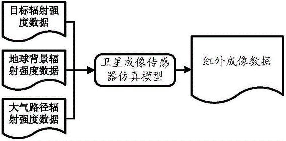
[0030] The invention provides a real-time space-based infrared visual simulation method, such as figure 1 As shown, this method obtains the target radiation intensity data, the earth background radiation intensity data and the atmospheric path radiation intensity data through simulation calculation, and then uses the satellite sensor simulation model to map the above three radiation intensity data into infrared imaging data, which can simulate the early warning satellite in real time. The infrared imaging process of the detection system for launch vehicles, missiles and other aircraft.
[0031] The implementation process of the present invention will be described below by taking the process of infrared imaging of the carrier rocket by the space-based early warning satellite detection system as an example.
[0032] (1) Calculation process of atmosp...
PUM
 Abstract
Description
Claims
Application Information