Method for reconstructing LiDAR original point cloud building contour

A technology of buildings and contour lines, applied to instruments, character and pattern recognition, computer components, etc., can solve problems such as inability to determine mutual positional relationship, no close connection, non-characteristic of target data, etc.

Active Publication Date: 2017-04-19
AIR FORCE UNIV PLA
View PDF4 Cites 22 Cited by
  • Summary
  • Abstract
  • Description
  • Claims
  • Application Information

AI Technical Summary

Problems solved by technology

The three-dimensional information of the target space acquired by LiDAR technology is discrete point data, and there is no close connection between points. The relationship between the adjacent points that should be the most relevant cannot be determined in the data.
[0007] 2. Non-characteristic problems of target data
For the original discrete point data, it is difficult to use existing methods to quickly extract features to obtain the target area
[0008] 3. Dealing with the regularity of the results

Method used


Image

  • Method for reconstructing LiDAR original point cloud building contour
  • Method for reconstructing LiDAR original point cloud building contour
  • Method for reconstructing LiDAR original point cloud building contour

Examples


Embodiment Construction

[0075] The technical solutions provided by the present invention will be described in detail below in conjunction with specific examples. It should be understood that the following specific embodiments are only used to illustrate the present invention and are not intended to limit the scope of the present invention.

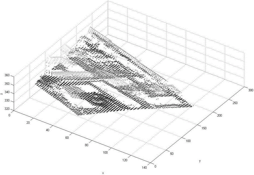
[0076] Raw LiDAR data in one embodiment of the present invention such as figure 1 shown.

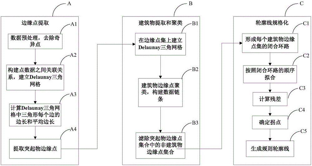
[0077] On the basis of the prior art and the key technical problems to be solved, the present invention proposes a new method for extracting LiDAR original point cloud building outlines, such as figure 2 shown, including:

[0078] Step A: Edge point extraction. On the basis of the LiDAR discrete point cloud, the triangular grid is constructed according to the principle of the Delaunay triangular network, and the relationship between the two-dimensional space of the data is established;

[0079] Step B: Building extraction and clustering. Extract two points with large e...


PUM


Abstract

The invention provides a method for reconstructing a LiDAR original point cloud building contour. The method includes constructing a triangular mesh according to the Delaunay triangular mesh principle on the basis of LiDAR discrete point cloud; extracting the two points with the greater elevation value in a triangle with a long edge in the Delaunay triangular mesh in a three dimensional space and storing the two points in a pair; taking the point pair as a data chain node and connecting the data chain nodes to form a circular data chain to completing the clustering of the edge points of each protruding object; counting the points in a point set of each protruding object and screening the non-building edge point set; and successively adding the points into the fitting data to be re-fitted according to the connection sequence, and connecting the intersection points of the adjacent fitting edges to obtain the contour of a building by taking the distance from the new point to the fitting straight line in the previous step as the criteria. The method is high in speed, speed, and accuracy, and solves the problems of discreteness and non-characteristics of the LiDAR data and the regularity of contour reconstruction.

Description

technical field [0001] The invention relates to a method for extracting the outline of the outer boundary of a building, in particular to a method for reconstructing the outline of the building's roof in the discrete point cloud data obtained by the airborne LiDAR. Background technique [0002] Building outline information has been widely used in many military and civilian related fields, especially in the establishment of urban digital models and planning management, the design of traffic lines, the survey of power lines, the detection and analysis of terrain, forest supervision, etc. As well as the field of precision target strike and damage effect assessment in modern combat plays an important role. [0003] LiDAR is a laser radar detection system that uses the Global Positioning System (GPS, Global Position System) and the Inertial Measurement Unit (IMU, Inertial Measurement Unit) to perform laser scanning to obtain three-dimensional information of the target. The data ...

Claims


Application Information

Patent Timeline
Patent Type & Authority Applications(China)
IPC IPC(8): G06K9/00G06K9/46
CPCG06V20/176G06V10/44
Inventor 程英蕾聂玉泽何曼芸邱浪波王黎光王晓薇胡丹赵忠阳
Owner AIR FORCE UNIV PLA
Why Eureka
Try Eureka