Method for creating mobile robot point cloud map based on laser data

A mobile robot, map creation technology, applied in navigation calculation tools and other directions, can solve the problem of low matching speed matching accuracy, and achieve the effect of multiple creation and rapid update, low cost and simple operation

Active Publication Date: 2017-05-31
ZHEJIANG UNIV
View PDF4 Cites 24 Cited by
  • Summary
  • Abstract
  • Description
  • Claims
  • Application Information

AI Technical Summary

Problems solved by technology

In general, the non-iterative matching algorithm has a fast matching speed but low matching accuracy. Combined with the requirements of map creation based on laser scanning data, the iterative matching algorithm is more suitable for mobile robot navigation systems

Method used


Image

  • Method for creating mobile robot point cloud map based on laser data
  • Method for creating mobile robot point cloud map based on laser data
  • Method for creating mobile robot point cloud map based on laser data

Examples


Embodiment Construction

[0044] The present invention will be further elaborated below in conjunction with the accompanying drawings and specific embodiments, so as to better understand the present invention. The technical features of the present invention can be combined with each other if there is no conflict.

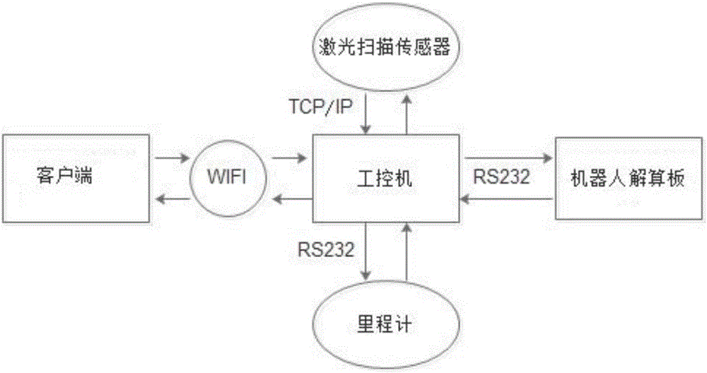
[0045] Such as figure 1 As shown, the mobile robot of the present invention has a built-in industrial computer, a calculation board, a laser sensor and an odometer, and the industrial computer and the calculation board communicate through the RS232 serial port. The industrial computer communicates remotely with the client through wifi. The client can be implemented in the form of PC, server, etc.

[0046] In this embodiment, the method for creating a point cloud map of a mobile robot based on laser data includes the following steps and sub-steps:

[0047] Step 1: Establish real-time communication and data transmission between the mobile robot and the client. Specific sub-steps:

[0048]...


PUM


Abstract

The invention discloses a method for creating a mobile robot point cloud map based on laser data. The method comprises the following steps: step 1, establishing real-time communication and data transmission between a mobile robot and a client; step 2, acquiring external environment data through a laser sensor and an odometer along with the motion of the mobile robot and transmitting to an industrial personal computer to generate a local data file; step 3, pre-processing the stored data aiming at the local data file and deleting a data frame of which the matching degree is lower than a threshold value; step 4, calculating offline calculation according to pre-acquired laser and odometer information to form the two-dimensional point cloud map in an environment where the robot is in. The method disclosed by the invention has the benefits that the data acquisition operation is simple, an environmental structure space does not need to be understood in advance, a landmark also does not need to be additionally laid, the cost is low, the map creation speed is high, the precision is high, and the multiple-creation and the rapid update of the map when the mobile robot is in an unknown environment can be realized.

Description

technical field [0001] The invention belongs to the field of intelligent robot navigation, in particular to a method for creating a point cloud map of a mobile robot based on laser data. Background technique [0002] Map creation is a basic and very important problem in mobile robot related technologies, and it has a wide range of applications in related fields such as mobile robot navigation and positioning and global path planning. In order to realize the autonomous navigation of the mobile robot, it is necessary to obtain the accurate pose of the robot in the environment through self-localization. Mobile robot localization and navigation techniques based on prior maps have been extensively researched and achieved promising results. However, the actual environment is often unknown, and a priori information such as the size, shape, and location of obstacles cannot be provided, and there are often no artificially set landmarks such as road signs and lighthouses in the actua...

Claims


Application Information

Patent Timeline
Patent Type & Authority Applications(China)
IPC IPC(8): G01C21/20
CPCG01C21/20
Inventor 于慧敏奚婉
Owner ZHEJIANG UNIV
Why Eureka
Try Eureka