SGOG tile-based large region true three-dimensional geographic scene adaptive construction method

A construction method and large-area technology, applied in the field of self-adaptive construction of large-area true 3D geographic scenes, to enhance visual effects, overcome deformation and cracks, and reduce data volume

Active Publication Date: 2017-06-27
ZHENGZHOU UNIV
View PDF8 Cites 12 Cited by
  • Summary
  • Abstract
  • Description
  • Claims
  • Application Information

AI Technical Summary

Problems solved by technology

However, all the above 3D models based on DGGs still belong to the category of surface

Method used


Image

  • SGOG tile-based large region true three-dimensional geographic scene adaptive construction method
  • SGOG tile-based large region true three-dimensional geographic scene adaptive construction method
  • SGOG tile-based large region true three-dimensional geographic scene adaptive construction method

Examples


Embodiment Construction

[0070] The following is an embodiment of the present invention.

[0071] Considering the computing and storage capabilities of a single computer, this embodiment selects the earth in mainland China as the research area, and takes the ninth layer of SGOG as the modeling basis. The spherical side length of the grid is about 19.5km, and the radial edge length is about 12.4km. Download 1144 pieces of 90m resolution DEM data covering mainland China from the sharing website. Basic parameters: projection UTM / WGS-84, GeoTIF format, 3601×3601 pixels, elevation is the geodetic height relative to the WGS-84 ellipsoid.

[0072] The invention utilizes IDL language to process DEM model source data, uses OSG as a graphics engine, uses VS2010 as a platform, and uses standard C++ as a development language to construct an experimental system.

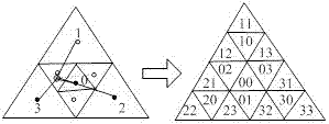
[0073] Such as Figure 7 As shown, the coordinate calculation and conversion of SGOG tile grid points are first performed, and the longitude and lati...


PUM


Abstract

The invention discloses an SGOG tile-based large region true three-dimensional geographic scene adaptive construction method. The method comprises the steps of processing DEM source data by utilizing an IDL, taking OSG as a graphic engine, taking VS2010 as a platform, and taking standard C++ as a development language, so that an experimental system is constructed; and performing DEM elevation calculation and matching by calculating and storing SGOG tile grid point coordinates, drawing tiles based on grid point elevation by the obtained SGOG grid point coordinates to construct a true three-dimensional terrain framework, performing modeling on the framework, and performing layered color setting and texture rendering. According to the method, large region crust true three-dimensional visualization modeling in view of earth curvature is realized; the defects of projection space model-based deformation, cracks and the like are overcome; integrated seamless organization and modeling of earth surface big data are realized; and natural manifold properties of a geographic space are recovered.

Description

technical field [0001] The invention belongs to the technical field of geographic information science, and in particular relates to a large-area true three-dimensional geographic scene self-adaptive construction method based on SGOG tiles. Background technique [0002] 1. Research Background [0003] In geographic information science, there are generally two methods for constructing 3D geographic scenes: one is the method of surface element model plus texture, which can often achieve better terrain and architectural visualization effects, and is widely used in the field of 3DGIS; the other is based on The modeling of voxel model is often used to express multiple vertical interfaces of geological bodies, and to facilitate the production of horizontal and vertical sections. It is widely used in 3D geoscience simulation information systems. Surface models cannot express complex geographic entities such as caves, arch bridges, and cliffs well, and it is difficult to realize ter...

Claims


Application Information

Patent Timeline
IPC IPC(8): G06T17/05
CPCG06T17/05
Inventor 王金鑫赵光成
Owner ZHENGZHOU UNIV
Why Eureka
Try Eureka