Method for automatically calculating crown projection area of single tree based on vehicle-mounted laser point cloud data

A point cloud data, vehicle-mounted laser technology, applied in the intersection of geographic information and information technology, can solve the problems of low degree of automation, difficult to accurately measure the canopy projection area, low precision, etc. The effect of precise measurement

Inactive Publication Date: 2017-07-04
SHANDONG UNIV OF SCI & TECH
View PDF2 Cites 22 Cited by
  • Summary
  • Abstract
  • Description
  • Claims
  • Application Information

AI Technical Summary

Problems solved by technology

Traditional measurement methods are complex in operation, low in accuracy, highly destructive, and low in au

Method used


Image

  • Method for automatically calculating crown projection area of single tree based on vehicle-mounted laser point cloud data
  • Method for automatically calculating crown projection area of single tree based on vehicle-mounted laser point cloud data
  • Method for automatically calculating crown projection area of single tree based on vehicle-mounted laser point cloud data

Examples


Embodiment Construction

[0039] The specific embodiment of the present invention will be further described below in conjunction with accompanying drawing and specific embodiment:

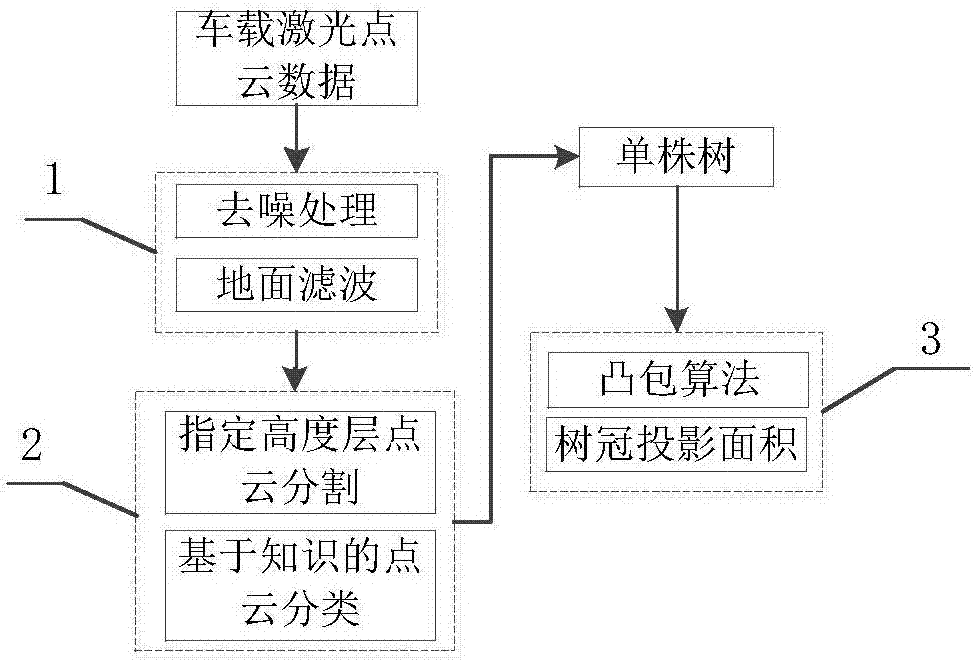
[0040] like Figure 1-5 As shown, the automatic calculation method of the crown projected area of ​​a single tree based on the vehicle-mounted laser point cloud data includes:

[0041] The vehicle-mounted laser mobile measurement system is used to obtain 3D point cloud data, and the object point cloud to be classified is obtained by processing the original point cloud data, and the classification method of layered projection is used to accurately identify individual trees according to the characteristics of different objects. Further use the convex hull algorithm to realize the automatic calculation of the projected area of ​​a single tree, including:

[0042] Point cloud data preprocessing 1, single tree point cloud extraction 2 and single tree crown projected area calculation 3;

[0043] Point cloud data preprocessing i...


PUM


Abstract

The invention discloses a method for automatically calculating the crown projection area of a single tree based on vehicle-mounted laser point cloud data, and specifically relates to a cross field of geographic information and information technologies. The method for automatically calculating the crown projection area of a single tree based on the vehicle-mounted laser point cloud data is characterized in that ground feature point cloud to be classified is acquired through preprocessing original point cloud data by using three-dimensional point cloud data acquired by a vehicle-mounted laser mobile measurement system, a single tree is accurately recognized according to characteristics of different ground features by using a classification method of hierarchical projection, and automatic calculation for the projection area of the single tree is realized by further utilizing a convex hull algorithm. According to the method, the single tree is extracted from mass point cloud data, and a problem of single tree extraction is solved. Furthermore, calculation for the crown projection area is performed, so that a problem that the crown projection area of the single tree is difficult to be measured accurately is solved, and automatic calculation and accurate measurement for the crown projection area of the single tree are realized.

Description

technical field [0001] The invention relates to the intersection field of geographic information and information technology, in particular to an automatic calculation method for the crown projection area of ​​a single tree based on vehicle-mounted laser point cloud data. Background technique [0002] Accurate measurement of a single tree is a necessary means for forestry practitioners to conduct research such as tree growth detection and biomass calculation. At the same time, in order to realize the dynamic update of the growth of a single tree, the measurement of a single tree must meet a certain accuracy. Traditional measurement methods are complex in operation, low in accuracy, highly destructive, and low in automation, especially the accurate measurement of the projected area of ​​tree crowns has always been a major difficulty. Contents of the invention [0003] The object of the present invention is to address the above-mentioned deficiencies, and proposes a method fo...

Claims


Application Information

Patent Timeline
IPC IPC(8): G01B11/28G06T7/11G06T7/62
CPCG01B11/28G01B5/0035G06T2207/10028
Inventor 闫兆进高静闫艳如王杰
Owner SHANDONG UNIV OF SCI & TECH
Why Eureka
Try Eureka