Plaque image and pollution feature coupling method for use in environmental risk assessment of regional tailing pond

A technology for environmental risk and tailings ponds, applied in character and pattern recognition, instruments, analysis materials, etc., can solve the problems of environmental risk assessment of regional tailings ponds, the probability of occurrence of risks, and the need for environmental risk supervision and other issues to achieve the effect of avoiding waste of resources

Active Publication Date: 2017-07-28
BEIJING MINING & METALLURGICAL TECH GRP CO LTD
View PDF4 Cites 14 Cited by
  • Summary
  • Abstract
  • Description
  • Claims
  • Application Information

AI Technical Summary

Problems solved by technology

Traditional technical means cannot solve the technical problems of regional tailings pool environmental risk assessment, and cannot solve the analysis problem that a single factor in the existing tailings pool environmental risk assessment work cannot objectively reflect the actual risk probability of accidents
A single risk factor and a single tailings pond environmental risk assessment for small-sc

Method used


Image

  • Plaque image and pollution feature coupling method for use in environmental risk assessment of regional tailing pond

Examples


Embodiment 1

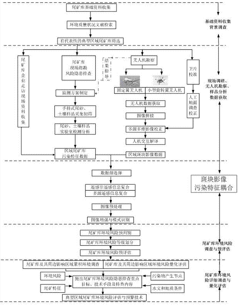
[0032] A coupling method of patch images and pollution features in the environmental risk assessment of domain tailings ponds, the method includes the following steps:

[0033] (1) Basic data collection and background investigation: specifically including the collection of basic data on tailings ponds and literature retrieval on environmental quality conditions, selecting representative and typical regional tailings ponds as research targets, and conducting on-site investigation of tailings ponds to investigate risks and hidden dangers;

[0034] (2) Multi-source and multi-dimensional data acquisition, using on-site survey, drone survey, sample analysis data acquisition, through site data collection of tailings pond enterprises, risk and hidden danger investigation of tailings site survey, drone survey, and satellite image calibration Four screening methods are used to screen, and the regional tailings pond pollution characteristic data is obtained through the collection of on-s...

Embodiment 2

[0039] According to the coupling method of patch images and pollution features in the environmental risk assessment of regional tailings ponds described in Example 1, the acquisition of environmental information of tailings ponds using multi-source multi-dimensional patch images and pollution characteristics adopts mesoscale, which is real-time and pertinent High-precision and high-resolution remote sensing survey of fixed-wing UAV; small-scale ground scanning of small-scale rotor UAV with rapidity and objectivity; hand-held ground monitoring for rapid screening and detailed inspection; easy to operate and accurate data The technical means combined with advanced ground tests; the satellite remote sensing image data of the tailings pond area reflecting the long-term succession process on a large scale as auxiliary evidence; the establishment of a tailings pond environmental information acquisition platform.

Embodiment 3

[0041] According to the patch image and pollution feature coupling method in the environmental risk assessment of regional tailings ponds described in Example 1 or 2, the multi-source multi-dimensional patch images of tailings ponds are cropped, spliced ​​and integrated to obtain tailings ponds and their surroundings Regional environmental change patch data images, through image processing, further accurately extract the boundary, area and feature information of the spatial distribution of environmental change patches; use the interpretation marks established by the feature image units as the discrimination mode, and use Data image map assists visual interpretation, human-computer interaction, information cutting, splicing and integration, and realizes information interpretation, extraction and map compilation.


PUM


Abstract

The invention discloses a plaque image and pollution feature coupling method for use in environmental risk assessment of regional tailing ponds; the method comprises: acquiring tailing pond environmental information of multi-source multi-dimensional plaque images and pollution features; cutting, assembling and integrating the multi-source multi-dimensional plaque images of the tailing ponds; establishing a plaque image and pollution feature data coupled model according to coupling association of spatial interpolation simulation, spatial data and attribute data; constructing a regional tailing pond environmental risk assessment index system that includes: quantitatively classifying regional tailing pond environmental risk values, using ArcGIS as an aid in conjunction with tailing pond environmental risk grading and accumulative environmental risk investigation results, using spatial representation technique to carry out key region accumulative environmental risk and tailing pond environmental risk quantitative assessment, and regionally dividing environmental risks of multiple tailing ponds in the region. The environmental risk assessment can be performed on the multiple tailing ponds in the region more accurately, and accurate basis is provided for the joint prevention and joint control decision-making for regional tailing ponds.

Description

technical field [0001] The invention relates to the technical field of environmental risk assessment of tailings ponds, in particular to a method for coupling plaque images and pollution features in environmental risk assessment of regional tailings ponds. Background technique [0002] In the 1970s, the United States first proposed the concept of Environmental Risk Assessment (ERA), which was gradually recognized later. With the development of environmental risk assessment, the concept of regional environmental risk has gradually been recognized. According to the temporal and spatial distribution of environmental risk, regional differences and consistency analysis are carried out. As a new idea of ​​regional environmental risk analysis, regional environmental risk assessment is a necessary part of environmental risk assessment and environmental risk management. [0003] There are 12,655 tailings ponds in my country, of which the proportion of dangerous, dangerous and diseas...

Claims


Application Information

Patent Timeline
IPC IPC(8): G01N23/223G06K9/00
CPCG01N23/223G01N2223/076G01N2223/1016G06V20/13
Inventor 林星杰刘楠楠苗雨楚敬龙谭海伟周连碧杨晓松赵志龙
Owner BEIJING MINING & METALLURGICAL TECH GRP CO LTD
Why Eureka
Try Eureka