Combined navigation method and device for unmanned aerial vehicle based on expanded auto-adaptive interval Kalman

A combined navigation and unmanned aerial vehicle technology, applied in navigation, surveying devices, surveying and navigation, etc., can solve time-varying problems and achieve the effects of improved adaptability, small quality and high precision

Inactive Publication Date: 2017-08-04
SOUTHEAST UNIV
View PDF7 Cites 25 Cited by
  • Summary
  • Abstract
  • Description
  • Claims
  • Application Information

AI Technical Summary

Problems solved by technology

However, when the system parameters or noise statistical characteristics are time-varying or not known exactly, the extended Kalman filter cannot do anything about it.

Method used


Image

  • Combined navigation method and device for unmanned aerial vehicle based on expanded auto-adaptive interval Kalman
  • Combined navigation method and device for unmanned aerial vehicle based on expanded auto-adaptive interval Kalman
  • Combined navigation method and device for unmanned aerial vehicle based on expanded auto-adaptive interval Kalman

Examples


Embodiment Construction

[0037] Below in conjunction with specific embodiment, further illustrate the present invention, should be understood that these embodiments are only used to illustrate the present invention and are not intended to limit the scope of the present invention, after having read the present invention, those skilled in the art will understand various equivalent forms of the present invention All modifications fall within the scope defined by the appended claims of the present application.

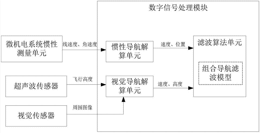
[0038] A UAV integrated navigation method based on extended adaptive interval Kalman disclosed in the embodiment of the present invention is as follows: Obtain the speed information and position information of the UAV in the navigation coordinate system through inertial navigation as the state information of the integrated navigation parameters ; Obtain the speed information and flight height information of the UAV in the horizontal direction under the navigation coordinate system through visual na...


PUM


Abstract

The invention discloses a combined navigation method and device for an unmanned aerial vehicle based on expanded auto-adaptive interval Kalman. The method comprises the following steps: measuring an inertial navigation parameter of the unmanned aerial vehicle by using a micro electro mechanical system inertial measurement unit and measuring a visual navigation parameter of the unmanned aerial vehicle by a visual navigation system; and by taking a digital signal processing module as a navigation computer, obtaining the optimum estimation of the navigation parameter of the system by taking an expanded auto-adaptive interval Kalman filter technology as a combined method fused with inertial and visual navigation parameters. The device disclosed by the invention is easy to realize, low in cost, relatively small in mass, relatively small in power consumption and suitable for being popularized in the civil field. A linear system model can be obtained by means of the expanded auto-adaptive interval Kalman filter technology. A time-varying parameter of the system is modeled as an auto-adaptive interval model, so that the capability of the navigation system operating the navigation positioning task during temperature variation, frequent gesture variation of a transporter and unsatisfactory lighting condition or in complex and severe conditions that a visual sensor is hard to fix the focus is improved.

Description

technical field [0001] The invention relates to an inertial / visual / ultrasonic integrated navigation method and device based on extended adaptive interval Kalman for unmanned aerial vehicles. Background technique [0002] With the development trend of miniaturization, intelligence, autonomy and low cost of the navigation system, and under the background that the importance of the autonomy of the navigation system is becoming more and more prominent, the inertial / visual integrated navigation technology, with its good complementary advantages and autonomous characteristics, has been It has become an important development direction in the field of navigation. In tasks such as fixed-point hovering, autonomous flight and landing of drones, target recognition and tracking of robots, and environmental detection, inertial / visual navigation technology has shown many advantages such as being able to interact with the external environment, good dynamic performance, and high real-time pe...

Claims


Application Information

Patent Timeline
Patent Type & Authority Applications(China)
IPC IPC(8): G01C21/00
CPCG01C21/005
Inventor 陈熙源章怀宇方琳柳笛汤新华
Owner SOUTHEAST UNIV
Why Eureka
Try Eureka