BIM (building information modeling) based VR (virtual reality) navigation method, server, terminal and system

A navigation method and virtual reality technology, applied in the field of navigation, can solve the problems of low navigation accuracy of the navigation system, achieve the effect of ensuring navigation accuracy, preventing entering wrong roads, and ensuring navigation accuracy

Inactive Publication Date: 2017-08-11
THE FIRST COMPARY OF CHINA EIGHTH ENG BUREAU LTD
View PDF8 Cites 7 Cited by
  • Summary
  • Abstract
  • Description
  • Claims
  • Application Information

AI Technical Summary

Problems solved by technology

[0005] In order to make up for the deficiencies of the prior art, the present invention provides a BIM-based virtual reality navig

Method used


Image

  • BIM (building information modeling) based VR (virtual reality) navigation method, server, terminal and system
  • BIM (building information modeling) based VR (virtual reality) navigation method, server, terminal and system
  • BIM (building information modeling) based VR (virtual reality) navigation method, server, terminal and system

Examples


Embodiment Construction

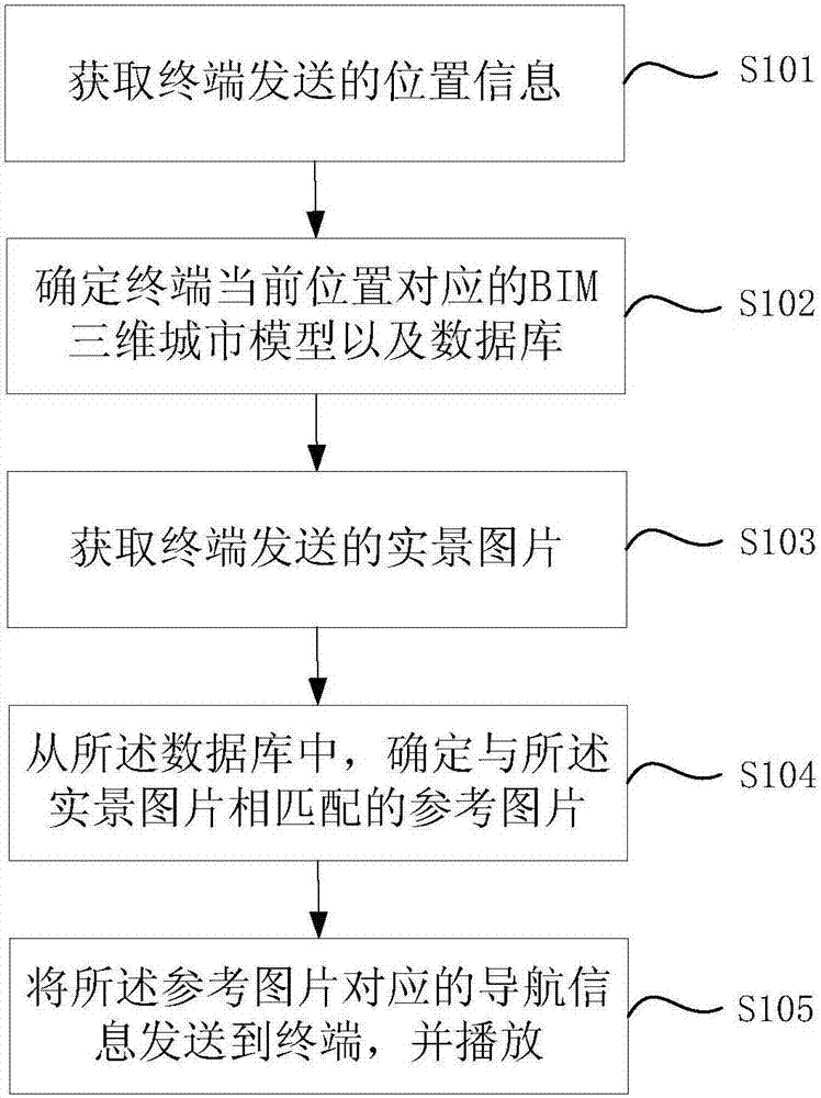
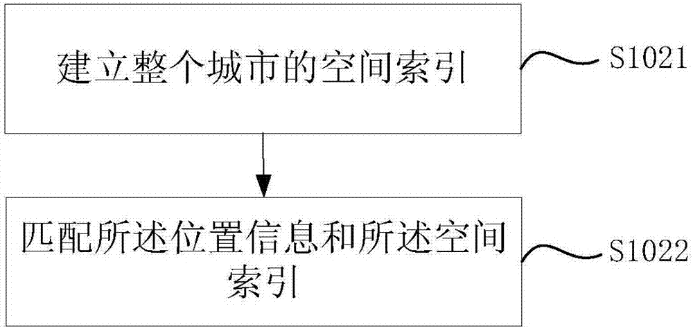
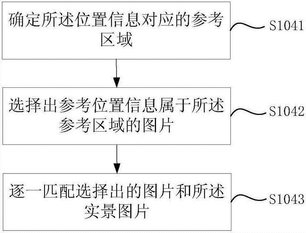
[0058] In order to clearly illustrate the technical features of this solution, the present invention will be described in detail below through specific implementation modes and in conjunction with the accompanying drawings.

[0059]During the navigation process, the user uses the terminal to set the origin and destination; wherein, the origin can be the current position positioned by the terminal, and for the destination, the user can use the terminal to input the name of the destination or enter the name on the terminal screen The method of clicking is not limited in this embodiment of the present invention.

[0060] The terminal sends the origin and destination set by the user to the server, and the server plans the travel route for the user according to the pre-stored urban geographic information and current traffic conditions, wherein the urban geographic information can be a two-dimensional electronic point map or A three-dimensional electronic map. In an embodiment of th...


PUM


Abstract

The invention relates to a BIM (building information modeling) based VR (virtual reality) navigation method, a server, a terminal and a system. The method comprises the following steps: the server acquires positional information sent by the terminal; a BIM three-dimensional city model corresponding to the current position of the terminal and a database are determined according to the positional information; a real scene picture sent by the terminal is acquired; a reference picture matched with the real scene picture is determined from the database; navigation information corresponding to the reference picture is sent to the terminal and played. In a navigation process, if the terminal cannot acquire the accurate positional information, the server still can acquire the real scene picture, shot by the terminal, of a travel route, whether a user travels on the planned travel route is determined by matching the reference picture in the database, and navigation precision is guaranteed; further, the user's terminal in the embodiment of the invention can display a BIM based three-dimensional city image in real time, more realistic virtual display navigation experience is provided for a user, the user is prevented from entering a wrong way, and the navigation precision is guaranteed.

Description

technical field [0001] The invention relates to the field of navigation technology, in particular to a virtual reality navigation method, server, terminal and system based on a three-dimensional city map constructed by BIM (English: Building Information Modeling, Chinese: Building Information Modeling). Background technique [0002] When people travel, the navigation device can plan the travel route for the user, and guide the driving direction for the user in real time, so that the user can reach the destination smoothly. [0003] In order to realize the navigation function, the current navigation equipment usually stores the two-dimensional electronic map of the city. When the user inputs the names of the origin and destination to the navigation equipment, the navigation equipment calculates the optimal travel route for the user according to the two-dimensional electronic map. . During the navigation process, the navigation device collects the user's position signal in re...

Claims


Application Information

Patent Timeline
IPC IPC(8): G01C21/34G01C21/30G06F17/30G06Q10/04H04L29/08H04W4/02
CPCH04W4/02G06F16/5866G06Q10/047G01C21/30G01C21/34G01C21/343H04L67/52
Inventor 李蕾于科葛振刚
Owner THE FIRST COMPARY OF CHINA EIGHTH ENG BUREAU LTD
Why Eureka
Try Eureka