Land coverage classification system and method
A classification method and coverage technology, applied in geographic information databases, structured data retrieval, instruments, etc., can solve the problems of time-consuming, high cost, and insufficient sample representativeness of land cover samples, and achieve enrichment of quantity and quality, Timely collection of data, improvement of classification efficiency and accuracy
- Summary
- Abstract
- Description
- Claims
- Application Information
AI Technical Summary
Problems solved by technology
Method used
Image

Examples
Embodiment 1
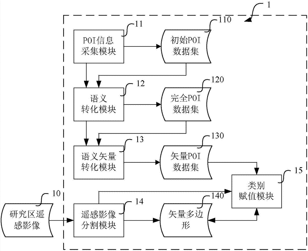
[0036] like figure 1 As shown, it is a functional block diagram of a land cover classification system provided by Embodiment 1 of the present invention. In this embodiment, the system includes a point of interest (POI for short) information collection module 11 , a semantic conversion module 12 , a semantic vector conversion module 13 , a remote sensing image segmentation module 14 and a category assignment module 15 .
[0037] Wherein, the POI information collection module 11 is connected with the system interface of the open source map system, and utilizes search keywords, such as place names or category keywords (such as schools, reservoirs and hospitals, etc.), to search for POI information in the open source map system , to obtain the map elements corresponding to the search keywords in the specified area, including the longitude, latitude and name of the POI. Store the obtained information in the data table of the database, and establish an ID number, each ID number cor...
specific Embodiment approach
[0042] After the land cover type information is added to each piece of POI information in the POI dataset, a notification is sent to the semantic vector conversion module 13 . After receiving the notification, the semantic vector conversion module 13 converts the POI information in the complete POI dataset 120 into geospatial vector data, which is named vector POI dataset 130 for the convenience of the following description. A specific implementation of the conversion process is as follows:
[0043] On a general geographic information system platform, such as the ArcMap platform, the Add Data tool is used to load the complete POI data set 120 of the text information format into the ArcMap platform; the Display XY Data tool in the platform is used to set the X attribute coordinates as longitude, Y The attribute coordinate is latitude, and the input coordinate system is GCS_WGS_1984 coordinate (coordinate unit: degree, coordinate central meridian: Greenwich 0° meridian, referenc...
Embodiment 2
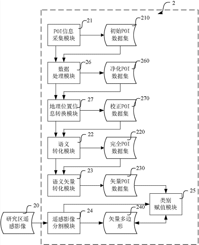
[0050] see figure 2 As shown, it is a functional block diagram of a land cover classification system provided by Embodiment 2 of the present invention. Compared with the first embodiment, the land cover classification system 2 of the second embodiment includes the POI information collection module 21, the semantic conversion module 22, the semantic vector conversion module 23, the remote sensing image segmentation module 24 and the same function as the first embodiment. In addition to the category assignment module 25, it also includes a purification processing module 26 and a geographic location information conversion module 27.
[0051] Wherein, after the cleaning processing module 26 receives the notification that the initial POI data set sent by the POI information collection module 21 is established, it detects whether the POI name in the initial POI information ends with a search keyword, and the specific detection method To: traverse each record in the initial POI dat...
PUM
 Abstract
Description
Claims
Application Information
 - R&D
- Intellectual Property
- Life Sciences
- Materials
- Tech Scout
- Unparalleled Data Quality
- Higher Quality Content
- 60% Fewer Hallucinations
Browse by: Latest US Patents, China's latest patents, Technical Efficacy Thesaurus, Application Domain, Technology Topic, Popular Technical Reports.
© 2025 PatSnap. All rights reserved.Legal|Privacy policy|Modern Slavery Act Transparency Statement|Sitemap|About US| Contact US: help@patsnap.com