New path planning method based on regular grid DEM data

A technology of path planning and new method, applied in directions such as navigation calculation tools, can solve problems such as damaged routes, slow map update, imperfect electronic maps, etc., to improve efficiency and effectiveness, improve rescue success rate, and reduce arrival time. Effect

Active Publication Date: 2017-10-03
GUILIN UNIV OF ELECTRONIC TECH
View PDF4 Cites 26 Cited by
  • Summary
  • Abstract
  • Description
  • Claims
  • Application Information

AI Technical Summary

Problems solved by technology

The use of electronic maps has its limitations: (1) Due to the large workload of electronic maps, the map update is slow; (2) The electronic maps are not perfect, and many areas have not been covered; (3) Natural disasters may also destroy the

Method used


Image

  • New path planning method based on regular grid DEM data
  • New path planning method based on regular grid DEM data
  • New path planning method based on regular grid DEM data

Examples


Embodiment

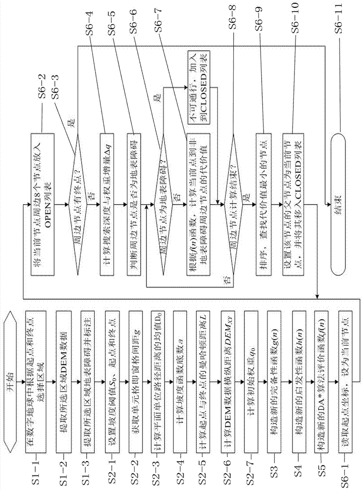
[0080] Such as figure 1 As shown, the present invention proposes a new method for path planning based on regular grid DEM data for disaster relief, specifically comprising the following steps:

[0081] S1: First extract and process data;

[0082] S1-1: Area selection, in the digital earth, set the rescue point as the starting point, and set the disaster point as the end point; select a rectangular area as small as possible but including the start point and end point according to the start point and end point;

[0083] S1-2: extract the DEM data of the selected area from the digital earth;

[0084] S1-3: Extract and mark the surface obstacles in the selected area.

[0085] S2: Perform parameter calculation;

[0086] S2-1: Set a slope threshold S that does not affect the speed of rescue vehicles and rescue equipment 0 ; and mark the starting point and the ending point to obtain the relevant information of the starting point and the ending point, including coordinate values, ...


PUM


Abstract

The present invention discloses a new path planning method based on regular grid DEM data. According to the new path planning method, the distance and the slope are used as the evaluation indexes of the path search; in order to balance the interaction between the distance and the slope, the complete function g(n) of a DA* algorithm is designed based on the distance function of the space path and the slope function constructed with the exponential function; the parameter in the function is calculated with the DEM data, and the new complete function g(n) is optimized so as to be adapted to the change of different resolutions of the DEM data; based on the same strategy and the function construction method, the new heuristic function h(n) of the DA* algorithm is constructed; and in order to improve the search efficiency of the algorithm, by setting the initial weight and dynamically adjusting the weight in the search process, the influence of the complete function and the heuristic function on the evaluation result is changed, such that the new constructed DA* path finding algorithm can efficiently search the appropriate path. According to the preset invention, the new path planning method can self-adapt to the DEM data resolution, and can be used in different application environments.

Description

technical field [0001] The invention relates to the technical field of path planning, in particular to a new path planning method based on regular grid DEM data in disaster relief. Background technique [0002] Disaster rescue is a social assistance system for the state or society to rescue and assist victims who are in trouble due to various disasters. Designing an optimal rescue path between the rescue point and the disaster-stricken point, so that rescue personnel, rescue vehicles, and rescue equipment can arrive at the disaster-stricken point in the shortest time for rescue is the key to ensuring the success rate of rescue. Rescue vehicles and equipment are usually heavy, and their driving speed will be greatly affected in areas with high slopes, and detours will extend the distance, which delays the speed of rescue. Therefore, how to balance the slope and distance, find an optimal path between the rescue point and the disaster-stricken point, and shorten the rescue arr...

Claims


Application Information

Patent Timeline
IPC IPC(8): G01C21/20
CPCG01C21/20
Inventor 张润莲张鑫张楚芸叶志博武小年
Owner GUILIN UNIV OF ELECTRONIC TECH
Why Eureka
Try Eureka